London Borough of Islington
| London Borough of Islington | |||
|---|---|---|---|
| London borough | |||
| |||
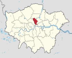 Islington shown within Greater London | |||
| Sovereign state | United Kingdom | ||
| Constituent country | England | ||
| Region | London | ||
| Ceremonial county | Greater London | ||
| Created | 1 April 1965 | ||
| Admin HQ | Upper Street, Islington | ||
| Government | |||
| • Type | London borough council | ||
| • Body | Islington London Borough Council | ||
| • Leadership | Leader & Cabinet (Labour) | ||
| • Mayor | Cllr Richard Greening | ||
| • London Assembly | Jennette Arnold (Labour) AM for North East | ||
| • MPs |
Jeremy Corbyn (Labour) Emily Thornberry (Labour) | ||
| • EU Parliament | London | ||
| Area | |||
| • Total | 14.86 km2 (5.74 sq mi) | ||
| Area rank | 324th (of 326) | ||
| Population (mid-2017 est.) | |||
| • Total | 235,000 | ||
| • Rank | 71st (of 326) | ||
| • Density | 16,000/km2 (41,000/sq mi) | ||
| • Ethnicity[1] |
47.7% White British | ||
| Time zone | UTC (GMT) | ||
| • Summer (DST) | UTC+1 (BST) | ||
| Postcodes | EC, N, NW, WC | ||
| Area code(s) | 020 | ||
| ONS code | 00AU | ||
| GSS code | E09000019 | ||
| Police | Metropolitan Police | ||
| Website | https://www.islington.gov.uk/ | ||
The London Borough of Islington (/ˈɪzlɪŋtən/ (![]()
The merged entity remains the second-smallest borough in London and the third-smallest district in England. The borough contains two Westminster parliamentary constituencies, Islington North, the constituency of Labour leader Jeremy Corbyn, and Islington South & Finsbury, the constituency of Labour Shadow Foreign Secretary and Shadow First Secretary of State Emily Thornberry. The local authority is Islington Council. The borough is home to football club Arsenal, one of the most successful clubs in England and its home Emirates Stadium that is one of the largest football stadiums in the country.
Etymology
Islington was originally named by the Saxons Giseldone (1005), then Gislandune (1062). The name means 'Gīsla's hill' from the Old English personal name Gīsla and dun 'hill', 'down'. The name then later mutated to Isledon, which remained in use well into the 17th century when the modern form arose.[2] In medieval times, Islington was just one of many small manors in the area, along with Bernersbury, Neweton Berewe or Hey-bury, and Canonesbury (Barnsbury, Highbury and Canonbury – names first recorded in the 13th and 14th centuries). "Islington" came to be applied as the name for the parish covering these villages, and was the name chosen for the Metropolitan Borough of Islington, on its formation in 1899. On the merger with Finsbury, to form the modern borough this name came to be applied to the whole borough.
Districts of Islington
The borough includes the areas:
- Angel
- Archway
- Barnsbury
- Canonbury
- Clerkenwell
- Farringdon
- Finsbury
- Finsbury Park (split between three boroughs. Other boroughs are London Borough of Haringey and London Borough of Hackney).
- Highbury
- Highgate
- Holloway
- Islington
- Kings Cross
- Lower Holloway
- Mildmay
- Nag's Head
- Newington Green
- Old Street
- Pentonville
- St Luke's
- Tufnell Park
- Upper Holloway
Wards
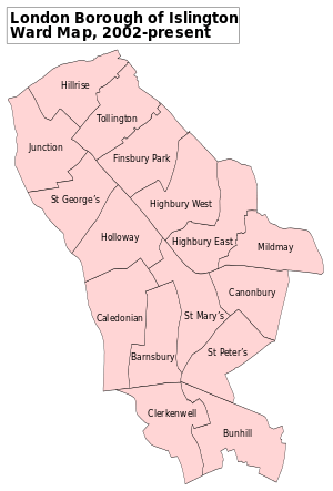
- Barnsbury
- Bunhill
- Caledonian
- Canonbury
- Newington Green
- Clerkenwell
- Finsbury Park
- Highbury East
- Highbury West
- Hillrise
- Holloway
- Junction
- Mildmay
- Saint Georges
- Saint Marys
- Saint Peters
- Tollington
Government and infrastructure
Islington Council is the borough's local authority. It is a London borough council, one of thirty-two principal subdivisions of the administrative area of Greater London. The council was created by the London Government Act 1963 and replaced two local authorities: Finsbury Metropolitan Borough Council and Islington Metropolitan Borough Council. The former Islington Metropolitan Town Hall, at the intersection of Upper Street and Richmond Grove, serves as the present Borough's council building.[3]
Islington is divided into 16 wards, each electing three councillors.[4] Following the May 2014 election, Islington Council comprises 47 Labour Party councillors and 1 Green Party councillor.[5] Of these 48 councillors, the Leader of the Council is Councillor Richard Watts, while the Mayor is Councillor Theresa Debono.[5][6]
Islington is represented by two parliamentary constituencies. Islington North is represented by Jeremy Corbyn of the Labour Party, the current Leader of the Opposition since 2015. Islington South and Finsbury is represented by Emily Thornberry of the Labour Party.
Islington forms part of the North East constituency for the London Assembly, represented by Jennette Arnold, also of the Labour Party.
Economy
Transport

Islington has a wide variety of transportation services, with direct connections to the suburbs and the City and West End. Islington also has ten tube stations within its boundaries, with connections by the tube to all around London.
London Underground
There are ten Underground stations in the borough:
- Angel
- Archway
- Arsenal
- Caledonian Road
- Farringdon
- Finsbury Park
- Highbury & Islington
- Holloway Road
- Old Street
- Tufnell Park
These stations principally serve the Northern, Piccadilly and Victoria lines. Farringdon station is also served by the Circle, Hammersmith & City and Metropolitan lines.
London Overground stations
There are also several London Overground stations in the borough. They are as follows:
Railway stations
There are several railway stations in the borough. They are as follows:
Travel to work
In March 2011, the main forms of transport that residents used to travel to work were: underground, metro, light rail, tram, 19.4% of all residents aged 16–74; bus, minibus or coach, 10.3%; on foot, 10.3%; bicycle, 6.2%; driving a car or van, 6.0%; train, 3.7%; work mainly at or from home, 3.6%.[8]
Major public and private bodies in Islington
Prisons
There is one prison in Islington, a men's prison, HM Prison Pentonville. Until it closed in 2016 there was also a women's prison HM Prison Holloway, which in the early 20th century was used to hold many suffragettes.
Cultural attractions and institutions in Islington
- Almeida Theatre
- Artillery Ground
- Pleasance Islington Theatre
- Courtyard Theatre
- Emirates Stadium (and the former Arsenal Stadium at Highbury)
- Angel Central (formerly the Islington N1 Centre)
- The Estorick Collection of Modern Italian Art in Canonbury Square
- Hen and Chickens Theatre
- Islington Arts Factory, in Parkhurst Road,
- London Canal Museum, located in New Wharf Road, King's Cross
- Islington Museum, located at Finsbury Library
- Islington Local History Centre, located at Finsbury Library
- John Salt, cocktail bar on Upper Street
- The King's Head Theatre
- Sadler's Wells Theatre
- Union Chapel
- Peter Benenson House, headquarters of Amnesty International
- Little Angel Theatre a puppet theatre and producer of the Suspense Puppetry Festival of London.
- VUE Cinema, located inside the N1 center
- Odeon Cinema, located on Holloway Road
- St John's Gate, Clerkenwell (Islington's badge for London2012)
- The Screen On The Green, a single screen cinema on Upper Street
- Holloway in Islington is home to Freightliners City Farm which is one of the many city farms throughout London. The farm contains a wide range of animals from rabbits to cows to chickens and pigs all free for the public to view.
Demographics
| Population | ||
|---|---|---|
| Year | Pop. | ±% |
| 1801 | 65,721 | — |
| 1811 | 83,679 | +27.3% |
| 1821 | 108,333 | +29.5% |
| 1831 | 137,271 | +26.7% |
| 1841 | 162,717 | +18.5% |
| 1851 | 214,090 | +31.6% |
| 1861 | 266,010 | +24.3% |
| 1871 | 317,930 | +19.5% |
| 1881 | 369,850 | +16.3% |
| 1891 | 397,799 | +7.6% |
| 1901 | 405,301 | +1.9% |
| 1911 | 412,944 | +1.9% |
| 1921 | 401,054 | −2.9% |
| 1931 | 389,513 | −2.9% |
| 1941 | 324,143 | −16.8% |
| 1951 | 269,743 | −16.8% |
| 1961 | 232,258 | −13.9% |
| 1971 | 200,022 | −13.9% |
| 1981 | 157,512 | −21.3% |
| 1991 | 173,384 | +10.1% |
| 2001 | 175,787 | +1.4% |
| 2011 | 206,125 | +17.3% |
| 2013 | 215,667 | +4.6% |
| Source: A Vision of Britain through time | ||
In 1801, the civil parishes that form the modern borough had a total population of 65,721. This rose steadily throughout the 19th century, as the district became built up; exceeding 200,000 in the middle of the century. When the railways arrived the rate of population growth increased—reaching nearly 400,000 by the turn of the century; with the Metropolitan Borough of Finsbury particularly suffering deprivation, poverty and severe overcrowding. The increase in population peaked before World War I, falling slowly in the aftermath until World War II began an exodus from London towards the new towns under the Abercrombie Plan for London (1944). The decline in population reversed in the 1980s, but it remains below its 1971 level.
According to the 2001 census Islington had a population of 175,797. It was 75% White, including 5% White Irish, 6% Black African, 5% Black Caribbean and 2% Bangladeshi. Thirty-two per cent of the borough's residents were owner–occupiers.
According to the 2011 census, Islington has the highest population density of local authorities in England and Wales—13,875 people per square kilometre.[9]
Islington has the second highest proportion of Irish people in the country, behind London Borough of Brent.[10]
A 2017 study by Trust for London and the New Policy Institute found that a third of Islington residents live in poverty. This is above the London average of 27%. It also found that just 14% of local employees are in jobs which pay below the London Living Wage - which is the 4th lowest figure of any London borough.[11]
The following table shows the ethnic group of respondents in the 2001 and 2011 census in Islington.
Ethnicity
| Ethnic Group | 2001[12] | 2011[13] | ||
|---|---|---|---|---|
| Number | % | Number | % | |
| White: British | 99,784 | 56.76% | 98,322 | 47.70% |
| White: Irish | 10,057 | 5.72% | 8,140 | 3.95% |
| White: Gypsy or Irish Traveller | 163 | 0.08% | ||
| White: Other | 22,623 | 12.87% | 33,890 | 16.44% |
| White: Total | 132,464 | 75.35% | 140,515 | 68.17% |
| Asian or Asian British: Indian | 2,851 | 1.32% | 3,534 | 2.06% |
| Asian or Asian British: Pakistani | 912 | 0.52% | 951 | 0.46% |
| Asian or Asian British: Bangladeshi | 4,229 | 2.41% | 4,662 | 2.26% |
| Asian or Asian British: Chinese | 3,074 | 1.75% | 4,457 | 2.16% |
| Asian or Asian British: Other Asian | 1,492 | 0.85% | 5,430 | 2.63% |
| Asian or Asian British: Total | 12,558 | 7.14% | 19,034 | 9.23% |
| Black or Black British: African | 10,500 | 5.97% | 12,622 | 6.12% |
| Black or Black British: Caribbean | 8,550 | 4.86% | 7,943 | 3.85% |
| Black or Black British: Other Black | 1,806 | 1.03% | 5,729 | 2.78% |
| Black or Black British: Total | 20,856 | 11.86% | 26,294 | 12.76% |
| Mixed: White and Black Caribbean | 2,329 | 1.32% | 4,236 | 2.06% |
| Mixed: White and Black African | 1,241 | 0.71% | 1,912 | 0.93% |
| Mixed: White and Asian | 1,543 | 0.88% | 2,964 | 1.44% |
| Mixed: Other Mixed | 2,121 | 1.21% | 4,227 | 2.05% |
| Mixed: Total | 7,234 | 4.11% | 13,339 | 6.47% |
| Other: Arab | 1,893 | 0.92% | ||
| Other: Any other ethnic group | 5,050 | 2.45% | ||
| Other: Total | 2,685 | 1.53% | 6,943 | 3.37% |
| Black, Asian, and minority ethnic: Total | 43,333 | 24.65% | 65,610 | 31.83% |
| Total | 175,797 | 100.00% | 206,125 | 100.00% |
Education
Universities
The London Borough of Islington is home to two higher education institutions:
- City, University of London at Northampton Square, formerly the Northampton Institute, founded in 1894; and
- London Metropolitan University, North Campus on the Holloway Road, formed from the merger of the University of North London and London Guildhall University in 2002. The University of North London was founded on this site in 1896 as the Northern Polytechnic Institute.
Moorfields Eye Hospital is a major centre for postgraduate training of ophthalmologists, orthoptists, optometrists, and nurses.
Colleges
The borough also currently contains two colleges of further education:
- City and Islington College; and
- Westminster Kingsway College (while major improvement works are carried out at King's Cross).
There are two performing arts colleges. The Urdang Academy and the Musical Theatre Academy are both based in Islington.
Schools
The borough currently maintains 47 primary schools, 10 secondary schools, three special schools and five Pupil Referral Units. In 2000, Cambridge Education Associates, a private firm, took over the management of the Islington's state schools from the local education authority.[14]
| Wikimedia Commons has media related to Churches in Islington. |
See also
References
- ↑ 2011 Census: Ethnic group, local authorities in England and Wales, Office for National Statistics (2012). See Classification of ethnicity in the United Kingdom for the full descriptions used in the 2011 Census.
- ↑ 'Islington: Growth', A History of the County of Middlesex: Volume 8: Islington and Stoke Newington parishes (1985), pp. 9-19 accessed: 13 March 2007
- ↑ "Islington Town Hall". Islington Council. Retrieved 22 July 2014.
- ↑ "Archived copy". Archived from the original on 9 October 2010. Retrieved 16 October 2010.
- 1 2 "Members of Islington Council". Islington Council. Retrieved 22 July 2014.
- ↑ "Council Leader". Islington Council. Retrieved 22 July 2014.
- ↑ "Privacy Policy." Immarsat. Retrieved on 26 March 2014. "99 City Road London EC1Y 1AX United Kingdom"
- ↑ "2011 Census: QS701EW Method of travel to work, local authorities in England and Wales". Office for National Statistics. Retrieved 23 November 2013. Percentages are of all residents aged 16-74 including those not in employment. Respondents could only pick one mode, specified as the journey’s longest part by distance.
- ↑ http://www.ons.gov.uk/ons/dcp171778_270487.pdf
- ↑ http://www.ons.gov.uk/ons/guide-method/census/2011/census-data/index.html 2011 Census: Ethnic group, local authorities in England and Wales
- ↑ "Trust for London". London's Poverty Profile. Retrieved 19 July 2018.
- ↑ "KS006 - Ethnic group". NOMIS. Retrieved 30 January 2016.
- ↑ "Ethnic Group by measures". NOMIS. Retrieved 8 January 2016.
- ↑ BBC education
External links
- Islington Links
- Islington Council
- Weather forecast for Islington
- Islington Museum and Local History Centre
| Districts |  | |
|---|---|---|
| Attractions |
| |
| Street markets | ||
| Parks and open spaces |
| |
| Constituencies | ||
| Tube and rail stations | ||
| Other topics | ||