Vélizy-Villacoublay
| Vélizy-Villacoublay | ||
|---|---|---|
| Commune | ||
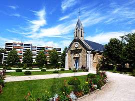 The church of Saint-Denis, in Vélizy-Villacoublay | ||
| ||
 Vélizy-Villacoublay Location within Île-de-France region  Vélizy-Villacoublay | ||
| Coordinates: 48°47′00″N 2°11′00″E / 48.7834°N 2.1834°ECoordinates: 48°47′00″N 2°11′00″E / 48.7834°N 2.1834°E | ||
| Country | France | |
| Region | Île-de-France | |
| Department | Yvelines | |
| Arrondissement | Versailles | |
| Canton | Versailles-2 | |
| Intercommunality | CA Versailles Grand Parc | |
| Government | ||
| • Mayor | Pascal Thévenot | |
| Area1 | 9.09 km2 (3.51 sq mi) | |
| Population (2006)2 | 20,030 | |
| • Density | 2,200/km2 (5,700/sq mi) | |
| Time zone | UTC+1 (CET) | |
| • Summer (DST) | UTC+2 (CEST) | |
| INSEE/Postal code | 78640 /78140 | |
| Elevation | 102–179 m (335–587 ft) | |
|
1 French Land Register data, which excludes lakes, ponds, glaciers > 1 km2 (0.386 sq mi or 247 acres) and river estuaries. 2 Population without double counting: residents of multiple communes (e.g., students and military personnel) only counted once. | ||

Vélizy-Villacoublay is a commune in the Yvelines department in the Île-de-France in north-central France. It is located in the south-western suburbs of Paris 13.9 km (8.6 mi) from the center and 3.2 km (2.0 mi) east of Versailles. Its inhabitants are called Véliziens.
Geography
Established on the Parisian plateau, the town of Vélizy-Villacoublay borders Meudon in the north-east, Clamart in the east, Bièvres in the south-east, Viroflay in the north-west, and Chaville in the north.
Vélizy-Villacoublay is a very urbanized town bordering the Meudon forest, which spans over 300 hectares (741 acres) of communal land.
There are six districts: Mozart, le Clos, le Mail, Louvois, la Pointe Ouest et Vélizy-le-Bas (with l'Ursine and le Bocage).
History
The word "Vélizy" comes from the Latin word villa. "Villacoublay" is formed from the same word, combined with the Gallo-Roman patronym "Escoblenus". Originally called simply Vélizy, the name of the commune became officially Vélizy-Villacoublay in 1938.
The territory was formed from three distinct manors: Vélizy, Villacoublay, and Ursine, established in the 11th century. The domains were progressively annexed into the royal estate beginning in the 12th century (Vélizy was annexed at the end of the 13th century).
The airbase in Villacoublay, Vélizy – Villacoublay Air Base, was built in 1911. In 1974 the Vélizy 2 shopping mall was opened.
The body of Diana, Princess of Wales was flown to RAF Northolt, west London, from here after her death in Paris on August 31, 1997.[1]
Main sights
- The Saint-Denis church
- The Saint-Jean-Baptiste church, in modern style.
- The barracks of the Compagnies Républicaines de Sécurité (CRS).
- l'Onde Cultural Center, finished in December 2000 and designed by the architect Claude Vasconi, which is composed of one hall with 670 seats, a multidisciplinary room of 200 seats, two large dance halls, an orchestra room, 12 studios, 4 classrooms, a recording room, and a percussion room.
Transport
Vélizy-Villacoublay is served by no station of the Paris Métro, RER, or suburban rail network. The closest station to Vélizy-Villacoublay is Chaville–Vélizy station on Paris RER line C. This station is located in the neighboring commune of Viroflay, 1.7 km (1.1 mi) from the town center of Vélizy-Villacoublay. Starting 2014, Vélizy-Villacoublay is served by a tramway line (line T6) with 7 stations.
The town is also serviced by the A86 autoroute, the 118 national route (RN118), and the RN286.
- Two-leveled tunnel under construction between Rueil-Malmaison and Vélizy-Villacoublay (a section of the A86)
- Covering of the A86
- The Veolia Transport bus line (Connex), of the RATP,
Economy
- Biggest Shopping Center of Île-de-France: Vélizy-2
- Car dealerships: Porsche, Audi, BMW, Mini, Citroën
- Numerous companies and offices:
- Aeronautic: EADS, MBDA, Messier-Dowty, Messier-Bugatti
- Agricultural: Kraft Foods
- Automotive: manufacturing plants of PSA Peugeot Citroën, Renault Trucks
- Building and Public Works Sector: Eiffage
- Electronics: Thales, Ateme
- Research: Laboratoire d'ingénierie des systèmes de Versailles
- Telecommunications: Alcatel-Lucent, Bouygues Télécom, Transcom, Sagem
- Information technology: Sun Microsystems, Dassault Systèmes, Quintiles/IMS Health
- Video Games: Blizzard (Vivendi-Universal Games)
- French Air Force Base 107 (HQ of French Special Forces)
- Group 61 of the CRS
Education
Twin towns
See also
References
- ↑ Walford, Charles (26 January 2012). "Historic RAF airfield used by the Queen 'to be sold to property developers in latest cuts plan'". Daily Mail. London.
External links
| Wikimedia Commons has media related to Vélizy-Villacoublay. |
- Official website (in French)