Hardricourt
| Hardricourt | ||
|---|---|---|
| Commune | ||
 Town hall | ||
| ||
 Hardricourt Location within Île-de-France region  Hardricourt | ||
| Coordinates: 49°00′32″N 1°53′40″E / 49.0089°N 1.8944°ECoordinates: 49°00′32″N 1°53′40″E / 49.0089°N 1.8944°E | ||
| Country | France | |
| Region | Île-de-France | |
| Department | Yvelines | |
| Arrondissement | Mantes-la-Jolie | |
| Canton | Les Mureaux | |
| Intercommunality | CU Grand Paris Seine et Oise | |
| Government | ||
| • Mayor (2001–2008) | André Cassagne | |
| Area1 | 3.28 km2 (1.27 sq mi) | |
| Population (2006)2 | 1,967 | |
| • Density | 600/km2 (1,600/sq mi) | |
| Time zone | UTC+1 (CET) | |
| • Summer (DST) | UTC+2 (CEST) | |
| INSEE/Postal code | 78299 /78250 | |
| Elevation |
18–118 m (59–387 ft) (avg. 58 m or 190 ft) | |
|
1 French Land Register data, which excludes lakes, ponds, glaciers > 1 km2 (0.386 sq mi or 247 acres) and river estuaries. 2 Population without double counting: residents of multiple communes (e.g., students and military personnel) only counted once. | ||

Hardricourt is a commune in the Yvelines department in the Île-de-France region in north-central France.
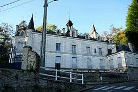
The castle of Hardricourt was between 1970 and 2011 property of Jean-Bedel Bokassa, from 1966 dictator and between 1977 and 1979, the year he was overthrown, self-appointed emperor of the Central African Republic. He lived in the castle in exile from c. 1983 to 1986.[1]
See also
References
| Wikimedia Commons has media related to Hardricourt. |
This article is issued from
Wikipedia.
The text is licensed under Creative Commons - Attribution - Sharealike.
Additional terms may apply for the media files.