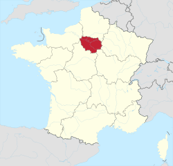
Île-de-France
| Île-de-France | |
|---|---|
| Region | |
 | |
| Country |
|
| Prefecture | Paris |
| Departments | |
| Government | |
| • President | Valérie Pécresse (LR) |
| Area | |
| • Total | 12,012 km2 (4,638 sq mi) |
| Population (Jan. 2014)[1] | |
| • Total | 12,005,077 |
| • Density | 1,000/km2 (2,600/sq mi) |
| Time zone | UTC+1 (CET) |
| • Summer (DST) | UTC+2 (CEST) |
| ISO 3166 code | FR-IDF |
| GDP (2016)[2] | Ranked 1st |
| Total | €681 billion (US$850 bn) |
| Per capita | €56,000 (US$70,000) |
| NUTS Region | FR1 |
| Website | iledefrance.fr |
Île-de-France (/ˌiːl ![]()
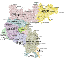
The region is made up of eight administrative departments: Paris, Essonne, Hauts-de-Seine, Seine-Saint-Denis, Seine-et-Marne, Val-de-Marne, Val-d'Oise and Yvelines. Created as the "District of the Paris Region" in 1961, it was renamed after the historic province of Île-de-France in 1976 when its administrative status was aligned with the other French administrative regions created in 1972. Residents are sometimes referred to as Franciliens, an administrative word created in the 1980s.
The GDP of the region in 2016 was €681 billion (or $850 billion USD at market exchange rates). It has the highest per-capita GDP among regions in France and the third-highest of regions in the European Union. In 2014, thirty companies from the Fortune Global 500 had their headquarters in the Paris region.
Etymology
Although the modern name Île-de-France literally means "Island of France", the etymology is in fact unclear. The "island" may refer to the land between the rivers Oise, Marne and Seine, or it may also have been a reference to the Île de la Cité, in which case "Island of France" was originally a pars pro toto or perhaps a metonym.
Yet another possibility is that the term is a corruption of a hypothesized Frankish language term Liddle Franke meaning "Little France" or "little Frankish land", so the modern reference to an "island" may be coincidental. However, this theory might be anachronistic, since the name L'Île-de-France (including the definite article) is not documented prior to 1387.
History

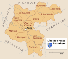
The ancient regime Isle of France (then referred as such in English) is one of the historical provinces of France, and the one at the centre of power during most of French history.
The province was centred on Paris, seat of the Crown of France. The area around Paris was the original personal domain of the King of France, as opposed to areas ruled by feudal lords of whom he was the suzerain. This is reflected by divisions such as the Vexin Français and the Vexin Normand, the former being within the King of France's domain, the latter being within the Duke of Normandy's fief.
The old provinces were abolished during the French Revolution in the late 18th century and divided between newly devised subdivisions called departments. An area not entirely corresponding to the historical Île-de-France province was created in 1959 as district de la région de Paris ("District of the Paris Region").
The district was reconstituted as the Île-de-France region on 6 May 1976 and increased administrative and political powers devolved in the process of regionalisation in the 1980s and 1990s.
Geography
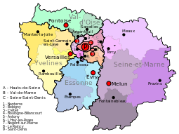
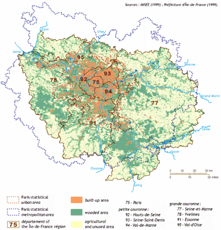
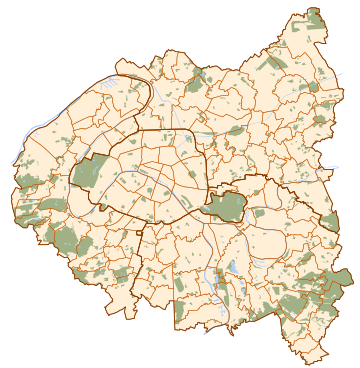
Île-de-France has a land area of 12,011 km2 (4,637 sq mi). It is composed of eight departments centered on its innermost department and capital, Paris. Around the department of Paris, urbanization fills a first concentric ring of three departments commonly known as the petite couronne ("small ring"), and extends into a second outer ring of four departments known as the grande couronne ("large ring"). The former department of Seine, abolished in 1968, included the city proper and parts of the petite couronne.
The petite couronne consists of the departments of Hauts-de-Seine, Seine-Saint-Denis, and Val-de-Marne, and the grande couronne of those of Seine-et-Marne, Yvelines, Essonne, and Val-d'Oise.
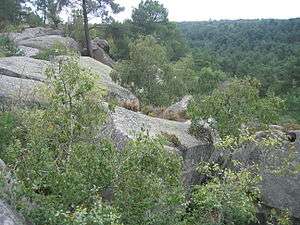
The river Seine runs through the region. The Seine has many tributaries, including the rivers Oise and Aube. It is France's second largest river after the Loire. The region is in an area of lowland called the Paris Basin. South of this region lies the Massif Central, an area of highlands that are higher than the surrounding countryside but far lower than the Alps.
Departments
Île-de-France comprises 8 departments : Paris, Essonne, Hauts-de-Seine, Seine-Saint-Denis, Seine-et-Marne, Val-de-Marne, Val-d'Oise, Yvelines.
Economy
The Paris region is France's premier center of economic activity, with a 2016 gross domestic product (GDP) of €681 billion (US$850 billion). In 2011, its GDP ranked second among the regions of Europe and its per-capita GDP was the fourth-highest in Europe.[3][4] While the Paris region's population accounted for 18.8% of metropolitan France in 2011,[5] the Paris region's GDP accounted for 30.1% of metropolitan France's GDP.[6] It hosts the world headquarters of thirty Fortune Global 500 companies.[7]
The regional economy has been gradually shifting towards high-value-added service industries (finance, IT services, etc.) and high-tech manufacturing (electronics, optics, aerospace, etc.).[8]
The Paris region's most intense economic activity takes place in the central Hauts-de-Seine department and suburban La Défense business district, in a triangle between the Opéra Garnier, La Défense and the Val de Seine.[8] While the Paris economy is dominated by services, and employment in manufacturing sector has declined sharply, the region remains an important manufacturing centre, particularly for the aeronautics, automotive, and "eco" industries.[8]
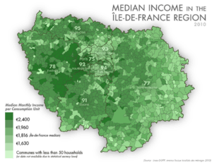
The per-capita income of the region is the largest of NUTS-1 Regions in the European Union and is third per capita after Luxembourg and Brussels with $71 126.[9]
Tourism in Paris is a major component of the regional economy, since the region includes both Paris and Disneyland Paris. The Paris region received 32,300,000 visitors in 2013, putting the region just ahead of London as the world's top tourist destination region, measured by hotel occupancy. The largest numbers of foreign tourists to the Paris region came in order from the United Kingdom, the United States, Germany, Italy and China.[10]
According to the 2011 French Census, 59.0% of the regional workforce is in commerce, transportation, and market services: 26.8% worked in non-market services (public administration, education, human health and social work activities); 8.6% worked in manufacturing, mining, and utilities; 5.3% worked in construction; and 0.3% worked in agriculture.[11]
The majority of the region's salaried employees fill 370,000 businesses services jobs, concentrated in the north-western 8th, 16th and 17th arrondissements.[12] Paris' financial service companies are concentrated in the central-western 8th and 9th arrondissement banking and insurance district.[12] Paris' department store district in the 1st, 6th, 8th and 9th arrondissements employs 10% of mostly female Paris workers, with 100 000 of these registered in the retail trade.[12] Fourteen% of Parisians work in hotels and restaurants and other services to individuals.[12] 19% of the Parisian workforce work for the state in either administration or education. The majority of Paris' health care and social workers work at the hospitals and social housing concentrated in the peripheral 13th, 14th, 18th, 19th and 20th arrondissements.[12] Outside Paris, the western Hauts-de-Seine department La Défense district specialising in finance, insurance and scientific research district is the largest dedicated business district in all of Europe and employs more than 150 000 as of 2012 and estimated to reach 200 000 by 2015 and 300 000 by 2019.[8] and the north-eastern Seine-Saint-Denis audiovisual sector has 200 media firms and ten major film studios.[8]
Paris' manufacturing is centred in its suburbs: the city itself has 75 000 workers employed in manufacturing; with most of these in the textile, clothing, leather goods and shoe trades.[8] Paris region manufacturing specialises in transportation, mainly automobiles, aircraft and trains, but this is in a sharp decline: Paris proper manufacturing jobs dropped by 64% between 1990-2010, and the Paris region lost 48% during the same period. Most of this is due to companies relocating outside the Paris region. The Paris region's 800 aerospace companies employed 100 000.[8] Four hundred automotive companies employ another 100 000 workers; many of these are in the Yvelines department around the Renault and PSA-Citroën plants (this department alone employs 33 000),[8] but the industry as a whole suffered a major loss with the closure in 2014 of a major Aulnay-sous-Bois Citroën assembly plant.[8]
The southern Essonne department specialises in science and technology,[8] and the south-eastern Val-de-Marne, with its wholesale Rungis food market, specialises in food processing and beverages.[8] The Paris region's manufacturing decline is quickly being replaced by eco-industries: these employ about 100 000 workers.[8] In 2011, while only 56 927 construction workers worked in Paris itself,[13] its metropolitan area employed 246 639,[11] in an activity centred largely around the Seine-Saint-Denis (41 378)[14] and Hauts-de-Seine (37 303)[15] departments and the new business-park centres appearing there.
Regional government and politics
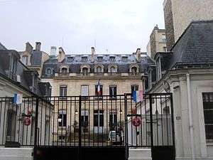
The Regional Council is the legislative body of the region. Its seat is in Paris, at 33 rue Barbet-de-Jouy in the 7th arrondissement. On December 15, 2015, a list of candidates of the Union of the Right, a coalition of centrist and right-wing parties, led by Valérie Pécresse, narrowly won the regional election, defeating the Union of the Left, a coalition of socialists and ecologists. The socialists had governed the region for the preceding seventeen years. In 2016, the new regional council will have 121 members from the Union of the Right, 66 from the Union of the Left and 22 from the far-right National Front.[16]
Holders of the executive office
- Delegates General for the District of the Paris Region
- 1961–1969: Paul Delouvrier (civil servant) – Very influential term. Responsible for the creation of the RER express subway network in the Île-de-France and beyond.
- 1969–1975: Maurice Doublet (civil servant)
- 1975–1976: Lucien Lanier (civil servant)
- Presidents of the Regional Council of Île-de-France
- 1976–1988: Michel Giraud (RPR politician) – (1st time)
- 1988–1992: Pierre-Charles Krieg (RPR politician)
- 1992–1998: Michel Giraud (RPR politician) – (2nd time)
- 1998-2015: Jean-Paul Huchon (PS)
- 2016- Valérie Pécresse (Union of the Centre-Right)
Political tendencies
| Election | Union for a Popular Movement (centre-right) | Socialist Party (centre-left) |
|---|---|---|
| 2012 Presidential election (2nd round) | 46.68% (Nicolas Sarkozy) | 53.32 % (François Hollande) |
| Regional Council (2010) | 67 (UMP-UDI-DVD) | 142 (PS-PRG-EELV-PCF-MRC-DVG) |
| Departmental Council (2015) | 5 | 3 |
| Deputies (2012) | 44 | 53 |
| Senators (2011) | 23 | 30 |
Demographics
Paris's demographic development, represented by the Paris Metropolitan Area, fills most of the Île-de-France: its central built-up area, or pôle urbain ("urban cluster"[17]) extends beyond the Île-de-France's inner three petite couronne departments, and this is surrounded by a commuter belt "rim"[18] that extends beyond the Region's four outer grande couronne departments in places.
 | |||||
| concentric area | department | population (Jan. 2011 estimate)[19] | area | population density | annual pop. growth 2006–2011[19] |
|---|---|---|---|---|---|
| the centre | Paris (75) | 2 249 975 | 105 km² | 21 428/km² | +0.62% |
| the inner ring (petite couronne) | Hauts-de-Seine (92) | 1 581 628 | 176 km² | 8 987/km² | +0.59% |
| Seine-Saint-Denis (93) | 1 529 928 | 236 km² | 6 483/km² | +0.50% | |
| Val-de-Marne (94) | 1 333 702 | 245 km² | 5 444/km² | +0.54% | |
| subtotal for the inner ring | 4 445 258 | 657 km² | 6 766/km² | +0.54% | |
| the outer ring (grande couronne) | Seine-et-Marne (77) | 1 338 427 | 5 915 km² | 226/km² | +1.00% |
| Yvelines (78) | 1 413 635 | 2 284 km² | 619/km² | +0.25% | |
| Essonne (91) | 1 225 191 | 1 804 km² | 679/km² | +0.45% | |
| Val-d'Oise (95) | 1 180 365 | 1 246 km² | 947/km² | +0.40% | |
| subtotal for the outer ring | 5 157 618 | 11 249 km² | 458/km² | +0.52% | |
| Total | 11 852 851 | 12 011 km² | 987/km² | +0.55% | |
Petite Couronne

The Petite Couronne[20] (Little Crown, i.e. Inner Ring) is the hub of the urban agglomeration of Paris. It is formed by the 3 departments of Île-de-France bordering with the French capital and forming a geographical crown around it. The departments, until 1968 part of the disbanded Seine department, are Hauts-de-Seine, Seine-Saint-Denis and Val-de-Marne. The most populated towns of the Petite Couronne are Boulogne-Billancourt, Montreuil, Saint-Denis, Nanterre and Créteil.
The Métropole du Grand Paris is an administrative structure that comprises Paris and the three departments of the Petite Couronne, plus seven additional communes in the Grande Couronne.
The table below shows some statistical information about the area including Paris:
| Department | Area (km²) | Population (2011)[19] | Municipalities |
|---|---|---|---|
| Paris (75) | 105.4 |
2 249 975 |
1 (Paris) |
| Hauts-de-Seine (92) | 176 |
1 581 628 |
|
| Seine-Saint-Denis (93) | 236 |
1 529 928 |
|
| Val-de-Marne (94) | 245 |
1 333 702 |
|
| Petite Couronne | 657 |
4 445 258 |
123 |
| Paris + Petite Couronne | 762.4 |
6 695 233 |
124 |
Grande Couronne
The Grande Couronne[21] (Greater Crown, i.e. Outer Ring) includes the towns of the metropolitan area part of the other 4 departments of Île-de-France not bordering with Paris. They are Seine-et-Marne (77), Yvelines (78), Essonne (91) and Val-d'Oise (95). The latter three departments formed the Seine-et-Oise department until this was disbanded in 1968. The city of Versailles is part of this area.
Historical population
| 1801 census | 1806 census | 1821 census | 1826 census | 1831 census | 1836 census | 1841 census | 1846 census | 1851 census | 1856 census | 1861 census | 1866 census |
|---|---|---|---|---|---|---|---|---|---|---|---|
| 1 352 280 | 1 407 272 | 1 549 811 | 1 780 900 | 1 707 181 | 1 882 354 | 1 998 862 | 2 180 100 | 2 239 695 | 2 552 980 | 2 819 045 | 3 039 043 |
| 1872 census | 1876 census | 1881 census | 1886 census | 1891 census | 1896 census | 1901 census | 1906 census | 1911 census | 1921 census | 1926 census | 1931 census |
| 3 141 730 | 3 320 162 | 3 726 118 | 3 934 314 | 4 126 932 | 4 368 656 | 4 735 580 | 4 960 310 | 5 335 220 | 5 682 598 | 6 146 178 | 6 705 579 |
| 1936 census | 1946 census | 1954 census | 1962 census | 1968 census | 1975 census | 1982 census | 1990 census | 1999 census | 2006 census | 2011 census | 2014 estimate |
| 6 785 750 | 6 597 758 | 7 317 063 | 8 470 015 | 9 248 631 | 9 878 565 | 10 073 059 | 10 660 554 | 10 952 011 | 11 532 398 | 11 852 851 | 12 005 077 |
| Census returns until 2011; official January estimates from INSEE from 2012 on. | |||||||||||
Immigration
| 2012 Census Paris Region[22][23] | |||||||||||||||||||||||||||||||||||||||||||
|---|---|---|---|---|---|---|---|---|---|---|---|---|---|---|---|---|---|---|---|---|---|---|---|---|---|---|---|---|---|---|---|---|---|---|---|---|---|---|---|---|---|---|---|
| Country/territory of birth | Population | ||||||||||||||||||||||||||||||||||||||||||
| 9,115,215 | |||||||||||||||||||||||||||||||||||||||||||
| 289,826 | |||||||||||||||||||||||||||||||||||||||||||
| 241,385 | |||||||||||||||||||||||||||||||||||||||||||
| 227,903 | |||||||||||||||||||||||||||||||||||||||||||
| 109,349 | |||||||||||||||||||||||||||||||||||||||||||
| 80,402 | |||||||||||||||||||||||||||||||||||||||||||
| 76,586 | |||||||||||||||||||||||||||||||||||||||||||
| 69,338 | |||||||||||||||||||||||||||||||||||||||||||
| 61,806 | |||||||||||||||||||||||||||||||||||||||||||
| 55,466 | |||||||||||||||||||||||||||||||||||||||||||
| 55,057 | |||||||||||||||||||||||||||||||||||||||||||
| 48,532 | |||||||||||||||||||||||||||||||||||||||||||
| 46,365 | |||||||||||||||||||||||||||||||||||||||||||
| 46,359 | |||||||||||||||||||||||||||||||||||||||||||
| 42,872 | |||||||||||||||||||||||||||||||||||||||||||
| 39,482 | |||||||||||||||||||||||||||||||||||||||||||
| |||||||||||||||||||||||||||||||||||||||||||
Paris and the Île-de-France region hosts one of the largest concentrations of immigrants in Europe. As of 2006, about 35% of people (4,000,000 people) living in the region were either immigrant (17%) or born to at least one immigrant parent (18%).[24]
At the 2010 census, 23.0% of the total population in the Île-de-France region had been born outside Metropolitan France, up from 19.7% at the 1999 census.[25]
International relations
Twin regions
Île-de-France is twinned with:


See also
Notes
- ↑ The flag is the France Moderne coat of arms (a simplified version of the France Ancien reduced the number of fleurs-de-lis to three), emblem of the French Monarchy, symbole of Île-de-France's prominence.
References
- 1 2 INSEE. "Estimation de population au 1er janvier, par région, sexe et grande classe d'âge – Année 2014" (in French). Retrieved 2015-03-29.
- ↑ Eurostat. "2016 GDP per capita in 276 EU regions". Retrieved 2016-10-07.
- ↑ INSEE statistics on GDPs of European regions
- ↑ "The Most Dynamic Cities of 2025". Foreign Policy. Retrieved 2 November 2014.
- ↑ "Estimation de population au 1er janvier, par région, sexe et grande classe d'âge". Institut National de la Statistique et des Études Économiques (in French). Retrieved 5 May 2013.
- ↑ "Produits Intérieurs Bruts Régionaux (PIBR) en valeur en millions d'euros" (XLS) (in French). INSEE. Retrieved 5 May 2013.
- ↑ Fortune. "Global Fortune 500". Retrieved 17 November 2014.
- 1 2 3 4 5 6 7 8 9 10 11 12 "L'Industrie en Île-de-France, Principaux Indicateurs Régionaux" (PDF). INSEE. Retrieved 24 November 2014.
- ↑ (in French)GDP per capita of french departments in 2005 ranks second in Europe after
- ↑ "Paris named as the world's top tourist destination". Daily Mail. Retrieved 28 November 2014.
- 1 2 "EMP2 - Emplois au lieu de travail par sexe, statut et secteur d'activité économique - Aire urbaine 2010 de Paris (001)" (in French). INSEE. Retrieved 17 November 2014.
- 1 2 3 4 5 "Île-de-France - A la Page Nº288 - INSEE 2007" (PDF) (Press release). November 2007. Retrieved 24 November 2014.
- ↑ "Emplois au lieu de travail - Département de Paris (75)". INSEE.
- ↑ "EMP2 - Emplois au lieu de travail par sexe, statut et secteur d'activité économique - Département de la Seine-Saint-Denis (93)" (in French). INSEE. Retrieved 17 November 2014.
- ↑ "EMP2 - Emplois au lieu de travail par sexe, statut et secteur d'activité économique - Département des Hauts-de-Seine (92)" (in French). INSEE. Retrieved 17 November 2014.
- ↑ Île-de-France Region official site. "Results of 2015 Regional Elections". Retrieved 16 December 2015.
- ↑ INSEE - Definitions and Methods - Pôle Urbain
- ↑ INSEE - Definitions and Methods - Couronne
- 1 2 3 INSEE. "Estimation de population au 1er janvier, par département, sexe et grande classe d'âge – Année 2011" (in French). Retrieved 2014-02-20.
- ↑ (in French) CIG "Petite Couronne" website (Centre Interdépartemental de Gestion)
- ↑ (in French) CIG "Grande Couronne" website (Centre Interdépartemental de Gestion)
- ↑ INSEE. "Données harmonisées des recensements de la population de 1968 à 2012" (in French). Retrieved 19 November 2015.
- ↑ INSEE. "Les immigrés par sexe, âge et pays de naissance - Région d'Île-de-France (11)" (in French). Retrieved 2015-11-19.
- ↑ Les descendants d'immigrés vivant en Île-de-France Archived 28 October 2011 at the Wayback Machine., IAU Idf, Note rapide Société, n° 531
- ↑ "Fichier Données harmonisées des recensements de la population de 1968 à 2010" (in French). INSEE. Retrieved 25 November 2013.
- ↑ "Yerevan - Partner Cities". Yerevan Municipality Official Website. Technology Management Center of Yerevan. Archived from the original on 5 November 2013. Retrieved 4 November 2013.
- ↑ "Hanoi strengthens ties with Ile-de-France". Voice of Vietnam. Retrieved 2018-05-04.
External links
| Wikimedia Commons has media related to Île-de-France. |
| Wikivoyage has a travel guide for Île-de-France. |
- Paris Region Map, The interactive economic map of Paris Region
- Regional Council of Île-de-France (in French)
- Île-de-France at Curlie (based on DMOZ)

Coordinates: 48°30′N 2°30′E / 48.500°N 2.500°E
| Authority control |
|---|