Athis-Mons
| Athis-Mons | ||
|---|---|---|
| Commune | ||
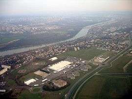 An aerial view of Athis-Mons | ||
| ||
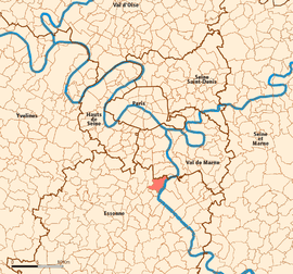 Location (in red) within Paris inner and outer suburbs | ||
| Coordinates: 48°42′27″N 2°23′20″E / 48.7074°N 2.3889°ECoordinates: 48°42′27″N 2°23′20″E / 48.7074°N 2.3889°E | ||
| Country | France | |
| Region | Île-de-France | |
| Department | Essonne | |
| Arrondissement | Palaiseau | |
| Canton | Athis-Mons | |
| Intercommunality |
Grand Paris EPT Grand-Orly Seine Bièvre | |
| Government | ||
| • Mayor (2014-2020) | Christine Rodier | |
| Area1 | 8.56 km2 (3.31 sq mi) | |
| Population (2015)2 | 32,792 | |
| • Density | 3,800/km2 (9,900/sq mi) | |
| Time zone | UTC+1 (CET) | |
| • Summer (DST) | UTC+2 (CEST) | |
| INSEE/Postal code | 91027 /91200 | |
| Elevation |
32–92 m (105–302 ft) (avg. 81 m or 266 ft) | |
|
1 French Land Register data, which excludes lakes, ponds, glaciers > 1 km2 (0.386 sq mi or 247 acres) and river estuaries. 2 Population without double counting: residents of multiple communes (e.g., students and military personnel) only counted once. | ||
.svg.png)
Athis-Mons (French pronunciation: [atisˈmɔ̃s]) is a commune in the southern suburbs of Paris, France. It is located 16.5 km (10.3 mi) from the center of Paris.
Inhabitants are called Athégiens.
A small part of Orly International Airport lies on the territory of the commune of Athis-Mons.[1]
History
Athis-Mons was formed in 1817 by joining two villages, Athis (along the Seine, and formerly known as Athis-sur-Orge[2]) and Mons (on the adjacent plateau). Nowadays the lower area of the commune is commonly called Athis-Val.
A significant portion (approximately 80%) of Athis-Mons was destroyed during the Allied bombing raid of 18 April 1944. Approximately 300 people died and 4,000 people were left homeless. Athis-Mons had to be entirely rebuilt after the war.
Geography
Athis-Mons is located at the confluence of Orge and Seine rivers, and at the southern edge of the international airport of Orly.
Administration
The canton of Athis-Mons has 2 communes (the other is Paray-Vieille-Poste) and 36,615 inhabitants. Athis-Mons is a twin town of Ballina in Ireland.
Transport
Athis-Mons is served by Athis-Mons station on Paris RER line C.
Education
The commune has nine preschools (écoles maternelles) and eight elementary schools (écoles élémentaires).[3]
- Preschools: Albert Calmette, Jules Ferry, Jean de la Fontaine, Pauline Kergomard, La Rougette, Charles Perrault, Jacques Prévert, Antoine de Saint-Exupéry,
- Elementary schools: Édouard Branly, Pierre et Marie Curie, Jules Ferry, Camille Flammarion, Jean Jaurès, Louis Pasteur, Antoine de Saint-Exupéry
- Combined preschools and elementary schools: Jean-Baptiste de la Salle
There is a private Catholic school, Groupe scolaire Saint-Charles d'Athis-Mons.
Twin towns
See also
References
- ↑ "Plans, cartes et vue aérienne." Athis-Mons. Retrieved on 6 October 2009.
- ↑ "Athis-Mons - History, Geography, & Points of Interest". britannica.com. Retrieved 8 April 2018.
- ↑ "Les écoles athégiennes." Athis-Mons. Retrieved on September 3, 2016.
External links
| Wikimedia Commons has media related to Athis-Mons. |
- Official website (in French)
- Mérimée database - Cultural heritage (in French)
- Land use (IAURIF) (in English)
| Authority control |
|---|