Courgent
| Courgent | |
|---|---|
| Commune | |
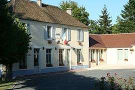 Town hall | |
 Courgent Location within Île-de-France region  Courgent | |
| Coordinates: 48°53′36″N 1°39′37″E / 48.8933°N 1.6603°ECoordinates: 48°53′36″N 1°39′37″E / 48.8933°N 1.6603°E | |
| Country | France |
| Region | Île-de-France |
| Department | Yvelines |
| Arrondissement | Mantes-la-Jolie |
| Canton | Bonnières-sur-Seine |
| Intercommunality | Pays houdanais |
| Government | |
| • Mayor (2001–2007) | Claude Fossé |
| Area1 | 2.02 km2 (0.78 sq mi) |
| Population (2006)2 | 403 |
| • Density | 200/km2 (520/sq mi) |
| Time zone | UTC+1 (CET) |
| • Summer (DST) | UTC+2 (CEST) |
| INSEE/Postal code | 78185 /78790 |
| Elevation |
57–119 m (187–390 ft) (avg. 100 m or 330 ft) |
|
1 French Land Register data, which excludes lakes, ponds, glaciers > 1 km2 (0.386 sq mi or 247 acres) and river estuaries. 2 Population without double counting: residents of multiple communes (e.g., students and military personnel) only counted once. | |

Sainte-Clotilde
Courgent is a commune in the Yvelines department in the Île-de-France region in north-central France.
See also
References
| Wikimedia Commons has media related to Courgent. |
This article is issued from
Wikipedia.
The text is licensed under Creative Commons - Attribution - Sharealike.
Additional terms may apply for the media files.