Les Mesnuls
| Les Mesnuls | |
|---|---|
| Commune | |
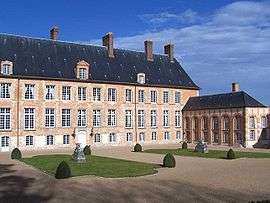 Chateau of Mesnuls | |
 Les Mesnuls Location within Île-de-France region  Les Mesnuls | |
| Coordinates: 48°45′25″N 1°50′20″E / 48.7569°N 1.8389°ECoordinates: 48°45′25″N 1°50′20″E / 48.7569°N 1.8389°E | |
| Country | France |
| Region | Île-de-France |
| Department | Yvelines |
| Arrondissement | Rambouillet |
| Canton | Aubergenville |
| Government | |
| • Mayor (2001–08) | Marc Lautour |
| Area1 | 6.49 km2 (2.51 sq mi) |
| Population (2006)2 | 897 |
| • Density | 140/km2 (360/sq mi) |
| Time zone | UTC+1 (CET) |
| • Summer (DST) | UTC+2 (CEST) |
| INSEE/Postal code | 78398 /78490 |
| Elevation |
93–184 m (305–604 ft) (avg. 112 m or 367 ft) |
|
1 French Land Register data, which excludes lakes, ponds, glaciers > 1 km2 (0.386 sq mi or 247 acres) and river estuaries. 2 Population without double counting: residents of multiple communes (e.g., students and military personnel) only counted once. | |
Les Mesnuls is a commune in the Yvelines department in the Île-de-France region in north-central France. It is located in the south-western suburbs of Paris 16 km (9.9 mi) north of Rambouillet, in the canton of Aubergenville.
History
The place was called Ménil until the 13th century, before becoming Les Mesnils, then Les Mesnuls. The name derives from Latin mansionile, meaning a small mansio, or dwelling
Interesting Sights
- Église Saint-Éloi, 15th century.
- The Château des Mesnuls : the first elements (entrance gate, moat) were built during the 16th century, and the main body dates from 1731. Protected since 1945, it is classified as monument historique since 1975.
- Chapelle Notre-Dame du Chêne on the road to Montfort-l'Amaury, built around 1825.
- Communal laundry house in rue du Moulin, 19th century.
See also
References
- Monique Bardy. La grande histoire des Yvelines, éditions Édijac, Pontoise 1989, ISBN 2-904625-25-6
| Wikimedia Commons has media related to Les Mesnuls. |
This article is issued from
Wikipedia.
The text is licensed under Creative Commons - Attribution - Sharealike.
Additional terms may apply for the media files.