Oinville-sur-Montcient
| Oinville-sur-Montcient | |
|---|---|
| Commune | |
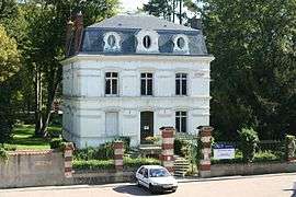 Town hall | |
 Oinville-sur-Montcient Location within Île-de-France region  Oinville-sur-Montcient | |
| Coordinates: 49°01′42″N 1°51′01″E / 49.0283°N 1.8503°ECoordinates: 49°01′42″N 1°51′01″E / 49.0283°N 1.8503°E | |
| Country | France |
| Region | Île-de-France |
| Department | Yvelines |
| Arrondissement | Mantes-la-Jolie |
| Canton | Limay |
| Intercommunality | CU Grand Paris Seine et Oise |
| Government | |
| • Mayor (2001–2008) | Stéphane Jeanne |
| Area1 | 3.87 km2 (1.49 sq mi) |
| Population (2006)2 | 1,150 |
| • Density | 300/km2 (770/sq mi) |
| Time zone | UTC+1 (CET) |
| • Summer (DST) | UTC+2 (CEST) |
| INSEE/Postal code | 78460 /78250 |
| Elevation |
36–135 m (118–443 ft) (avg. 100 m or 330 ft) |
|
1 French Land Register data, which excludes lakes, ponds, glaciers > 1 km2 (0.386 sq mi or 247 acres) and river estuaries. 2 Population without double counting: residents of multiple communes (e.g., students and military personnel) only counted once. | |
Oinville-sur-Montcient is a commune in the Yvelines department in the Île-de-France region in north-central France.
See also
References
| Wikimedia Commons has media related to Oinville-sur-Montcient. |
This article is issued from
Wikipedia.
The text is licensed under Creative Commons - Attribution - Sharealike.
Additional terms may apply for the media files.