Flexanville
| Flexanville | |
|---|---|
| Commune | |
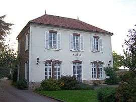 Town hall | |
 Flexanville Location within Île-de-France region  Flexanville | |
| Coordinates: 48°51′17″N 1°44′19″E / 48.8547°N 1.7386°ECoordinates: 48°51′17″N 1°44′19″E / 48.8547°N 1.7386°E | |
| Country | France |
| Region | Île-de-France |
| Department | Yvelines |
| Arrondissement | Rambouillet |
| Canton | Aubergenville |
| Government | |
| • Mayor (2001–2008) | Didier Saussay |
| Area1 | 8.89 km2 (3.43 sq mi) |
| Population (2006)2 | 588 |
| • Density | 66/km2 (170/sq mi) |
| Time zone | UTC+1 (CET) |
| • Summer (DST) | UTC+2 (CEST) |
| INSEE/Postal code | 78236 /78910 |
| Elevation |
95–140 m (312–459 ft) (avg. 121 m or 397 ft) |
|
1 French Land Register data, which excludes lakes, ponds, glaciers > 1 km2 (0.386 sq mi or 247 acres) and river estuaries. 2 Population without double counting: residents of multiple communes (e.g., students and military personnel) only counted once. | |
Flexanville is a commune in the Yvelines department in the Île-de-France region of north-central France.
River
The commune shares its name with a small river that passes through it, la Flexanville. This waterway flows through eight other communes for a total distance of 11.1 kilometres (6.9 mi). The Flexanville is a tributary of the Vaucouleurs which in turn empties into the Seine.[1]
Views
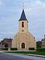 Local church
See also
References
- ↑ Sandre (2010). "La Flexanville (H3074000)". Eaufrance.fr (in French). Office national de l’eau et des milieux aquatiques. Retrieved 17 December 2011.
| Wikimedia Commons has media related to Flexanville. |
This article is issued from
Wikipedia.
The text is licensed under Creative Commons - Attribution - Sharealike.
Additional terms may apply for the media files.