RER C
| RER C | |||
|---|---|---|---|
 | |||
| Overview | |||
| Stations | 84 | ||
| Ridership | 140,000,000 journeys per year | ||
| Operation | |||
| Opened |
1979 (last extension in 2006) | ||
| Rolling stock | Z 5600, Z 8800, Z 20500, Z 20900 | ||
| Technical | |||
| Line length | 185.6 km (115.3 mi) | ||
| Track gauge | 1,435 mm (4 ft 8 1⁄2 in) | ||
| |||
The RER C is one of the five lines in the RER system serving Paris, France. It is operated by SNCF.
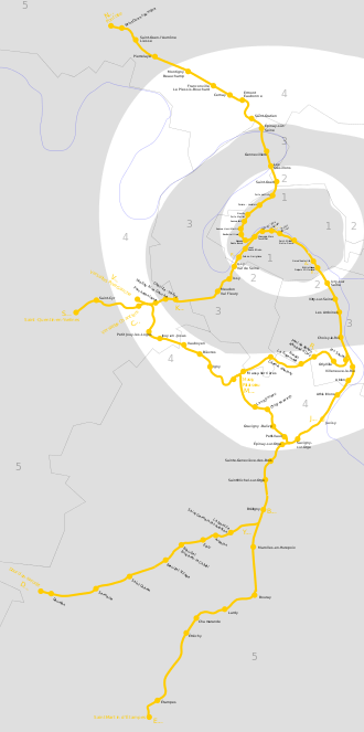
The line runs from the northwestern termini Pontoise (C1), Versailles-Château-Rive-Gauche (C5) and Saint-Quentin-en-Yvelines (C7) to the southeastern termini Massy-Palaiseau (C2), Dourdan-la-Forêt (C4), Saint-Martin d'Étampes (C6) and Versailles – Chantiers (C8).
The RER C line is the second-longest in the network, with over 187 km (116 mi) of route. RER C was created from an amalgamation and renovation of several old SNCF commuter lines unlike RER A and B which had newer sections owned and constructed by RATP. Each day, over 531 trains run on the RER C alone, and carries over 540,000 passengers daily,[1] which is 150,000 passengers more than the entirety of the TGVs network. It is also the most popular RER line for tourists which represents 15% of its passengers, as the line serves many monuments and museums, including the Palace of Versailles. The numerous stops combined with an old and fragile infrastructure the line inherited, makes the Parisian section of the RER C very slow and inefficient. The numerous old curves and steep grades on RER C means trains sometimes need to slow down to 40 km/h (25 mph) to safely pass sections with tight alignments.[2] In contrast, RER A was constructed with more modern standards enabling much higher average operating speeds. These problems are particularly evident on trips to and from the northern suburbs to the city center as taking Transilien lines and transferring to the Métro is much faster than taking the meandering RER C with closely spaced stops. In addition, the RER C's complicated operating schedule created by its complex network of numerous branches means the entire line is vulnerable to delays from even the smallest incidents. These issues have led to the line been called "réseau escargot régional" (Regional Snail Network) by the local populace.[3]
History

Line C was opened on 26 September 1979 following the construction of a new 1-kilometre (0.62 mi) tunnel connecting the Gare d'Orsay railway terminus (now Musée d'Orsay) with the Invalides terminus of the Rive Gauche line to Versailles, along the banks of the Seine. Services operated between Versailles-Château-Rive-Gauche – Invalides – Quai-d'Orsay, branching to Massy – Palaiseau, and Juvisy – Dourdan / Saint-Martin d'Étampes.
May 1980 : Service extended Saint-Quentin-en-Yvelines – Versailles – Chantiers – Gare des Invalides.
On 25 September 1988 the VMI ("Vallée de Montmorency – Invalides") branch to the north-west opened. This branch mostly used the infrastructure of the "ligne d'Auteuil" (incorporated into the "ligne de petite ceinture" from 1867, closed to passengers from 22 July 1934), and a new 3 kilometres (1.9 mi) tunnel connection between Batignolles and St-Ouen, connecting to the RER C's main trunk at Champ de Mars-Tour Eiffel via a curved bridge (the only one in Paris) over the Seine river. This extended services to Montigny – Beauchamp and Argenteuil.
Porte de Clichy opened on 29 September 1991. Located between Pereire – Levallois and St-Ouen.
In 1992 the line was extended from Juvisy to Versailles.
A further 9 kilometres (5.6 mi) extension from Montigny – Beauchamp to Pontoise was opened on 28 August 2000. On the same day a new station, Bibliothèque François Mitterrand, opened in order to create a new connexion with Métro Line 14. Located between Paris-Austerlitz and Boulevard Masséna (which was closed and replaced by the new station).
Another new station, St-Ouen-l'Aumône-Liesse, opened on 24 March 2002. Located between Pierrelaye and St-Ouen-l'Aumône.
The C3 branch (from Ermont-Eaubonne to Argenteuil) transferred to the Transilien Paris – Saint-Lazare suburban rail network on 27 August 2006.
On 16 December 2006, Boulevard Victor was renamed Boulevard Victor – Pont du Garigliano to highlight the new interchange with tramway line T3.
In February 2012, Versailles - Rive Gauche was renamed Versailles-Château-Rive-Gauche, to avoid frequent tourist confusion with other stations in Versailles.
See also
References
- ↑ « JEUDI, le mag des jeudis de la ligne C Transilien », 27, Novembre 2012, page 2 (consulté le 31 décembre 2016).
- ↑ André Jacquot, La ligne C du RER, p 108
- ↑ "Changements dans l'air dans le RER". metro-pole.net, via web.archive.org. 15 December 2007. Archived from the original on 25 December 2013. Retrieved 12 May 2015. .
External links

- RATP official website (in French)
- RATP English website
- Interactive map of the RER (from RATP's website)
- Interactive map of the Paris métro (from RATP's website)
- Mobidf website, dedicated to the RER (unofficial) (in French)
- Metro-Pole website, dedicated to Paris public transports (unofficial) (in French)
| ||
| ||
| Finance | ||
| Related articles | ||
| Termini |
|  | |||||||||
|---|---|---|---|---|---|---|---|---|---|---|---|
| SNCF | |||||||||||
| RER |
| ||||||||||