Herbeville
| Herbeville | |
|---|---|
| Commune | |
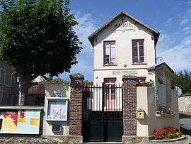 Town hall | |
 Herbeville Location within Île-de-France region  Herbeville | |
| Coordinates: 48°54′24″N 1°53′14″E / 48.9067°N 1.8872°ECoordinates: 48°54′24″N 1°53′14″E / 48.9067°N 1.8872°E | |
| Country | France |
| Region | Île-de-France |
| Department | Yvelines |
| Arrondissement | Saint-Germain-en-Laye |
| Canton | Aubergenville |
| Government | |
| • Mayor (2008–2013) | Laurent Thiriau |
| Area1 | 6.40 km2 (2.47 sq mi) |
| Population (2006)2 | 294 |
| • Density | 46/km2 (120/sq mi) |
| Time zone | UTC+1 (CET) |
| • Summer (DST) | UTC+2 (CEST) |
| INSEE/Postal code | 78305 /78580 |
| Elevation |
54–185 m (177–607 ft) (avg. 137 m or 449 ft) |
|
1 French Land Register data, which excludes lakes, ponds, glaciers > 1 km2 (0.386 sq mi or 247 acres) and river estuaries. 2 Population without double counting: residents of multiple communes (e.g., students and military personnel) only counted once. | |
Herbeville is a commune in the Yvelines department in the Île-de-France region in north-central France.
See also
References
| Wikimedia Commons has media related to Herbeville. |
This article is issued from
Wikipedia.
The text is licensed under Creative Commons - Attribution - Sharealike.
Additional terms may apply for the media files.