Moisson
| Moisson | |
|---|---|
| Commune | |
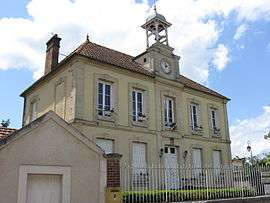 The town hall in Moisson | |
 Moisson Location within Île-de-France region  Moisson | |
| Coordinates: 49°04′29″N 1°40′04″E / 49.0747°N 1.6678°ECoordinates: 49°04′29″N 1°40′04″E / 49.0747°N 1.6678°E | |
| Country | France |
| Region | Île-de-France |
| Department | Yvelines |
| Arrondissement | Mantes-la-Jolie |
| Canton | Bonnières-sur-Seine |
| Intercommunality | Portes de l’Île-de-France |
| Government | |
| • Mayor (2001–2008) | Danielle Gouriou |
| Area1 | 9.70 km2 (3.75 sq mi) |
| Population (2006)2 | 918 |
| • Density | 95/km2 (250/sq mi) |
| Time zone | UTC+1 (CET) |
| • Summer (DST) | UTC+2 (CEST) |
| INSEE/Postal code | 78410 /78840 |
| Elevation |
11–43 m (36–141 ft) (avg. 20 m or 66 ft) |
|
1 French Land Register data, which excludes lakes, ponds, glaciers > 1 km2 (0.386 sq mi or 247 acres) and river estuaries. 2 Population without double counting: residents of multiple communes (e.g., students and military personnel) only counted once. | |
Moisson is a commune in the Yvelines department in the Île-de-France region in north-central France.
History
On 12 November, 1903, the Lebaudy brothers made a controlled dirigible flight of 54 km (34 mi) from Moisson to Paris.
Moisson was the site of the 6th World Scout Jamboree, held in 1947, which brought together 24,152 Scouts and Guides from all over the world.
See also
References
| Wikimedia Commons has media related to Moisson (Yvelines). |
This article is issued from
Wikipedia.
The text is licensed under Creative Commons - Attribution - Sharealike.
Additional terms may apply for the media files.