La Verrière
| La Verrière | ||
|---|---|---|
| Commune | ||
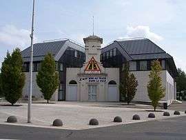 Town hall | ||
| ||
 La Verrière Location within Île-de-France region  La Verrière | ||
| Coordinates: 48°45′33″N 1°57′47″E / 48.7592°N 1.9631°ECoordinates: 48°45′33″N 1°57′47″E / 48.7592°N 1.9631°E | ||
| Country | France | |
| Region | Île-de-France | |
| Department | Yvelines | |
| Arrondissement | Rambouillet | |
| Canton | Trappes | |
| Intercommunality | Saint-Quentin-en-Yvelines | |
| Government | ||
| • Mayor (2008–2014) | Pierre Sellincourt (PCF) | |
| Area1 | 1.77 km2 (0.68 sq mi) | |
| Population (2006)2 | 6,165 | |
| • Density | 3,500/km2 (9,000/sq mi) | |
| Time zone | UTC+1 (CET) | |
| • Summer (DST) | UTC+2 (CEST) | |
| INSEE/Postal code | 78644 /78320 | |
| Elevation |
166–175 m (545–574 ft) (avg. 169 m or 554 ft) | |
|
1 French Land Register data, which excludes lakes, ponds, glaciers > 1 km2 (0.386 sq mi or 247 acres) and river estuaries. 2 Population without double counting: residents of multiple communes (e.g., students and military personnel) only counted once. | ||
.svg.png)
La Verrière is a commune in the Yvelines department in the Île-de-France in north-central France.
Transport
Gare de La Verrière serves the commune.
Education
Preschools and elementary schools in La Verrière:[1][2]
- École du Parc
- École régionale
- École du Bois de l’Étang
Preschools:[1]
- École des Noës
Collège intercommunal Philippe de Champaigne in Le Mesnil-Saint-Denis serves the junior high school students of La Verrière.[3]
Area senior high schools/sixth form colleges are located in other communes:[3]
- Lycée Dumont d’Urville Elancourt-Maurepas, Maurepas
- Lycée des Sept-Mares, Maurepas
- Lycée de la Plaine de Neauphle, Trappes
- Lycée d’Enseignement Professionnel Industriel Louis Blériot, Trappes
Versailles Saint-Quentin-en-Yvelines University provides tertiary educational services.[3]
See also
References
- 1 2 "Vie scolaire (2-6 ANS)." La Verrière. Retrieved on September 3, 2016.
- ↑ "Vie scolaire (6-11 ANS)." La Verrière. Retrieved on September 3, 2016.
- 1 2 3 "Jeunesse > Les établissements ." La Verrière. Retrieved on September 3, 2016.
External links
| Wikimedia Commons has media related to La Verrière. |
- Home page (in French)
This article is issued from
Wikipedia.
The text is licensed under Creative Commons - Attribution - Sharealike.
Additional terms may apply for the media files.