Andelu
| Andelu | ||
|---|---|---|
| Commune | ||
 Town hall | ||
| ||
 Andelu Location within Île-de-France region  Andelu | ||
| Coordinates: 48°52′52″N 1°49′30″E / 48.881°N 1.825°ECoordinates: 48°52′52″N 1°49′30″E / 48.881°N 1.825°E | ||
| Country | France | |
| Region | Île-de-France | |
| Department | Yvelines | |
| Arrondissement | Saint-Germain-en-Laye | |
| Canton | Aubergenville | |
| Intercommunality | Gally Mauldre | |
| Government | ||
| • Mayor (2014-2020) | Olivier Ravenel | |
| Area1 | 3.96 km2 (1.53 sq mi) | |
| Population (2014)2 | 470 | |
| • Density | 120/km2 (310/sq mi) | |
| Time zone | UTC+1 (CET) | |
| • Summer (DST) | UTC+2 (CEST) | |
| INSEE/Postal code | 78013 /78770 | |
| Elevation |
111–133 m (364–436 ft) (avg. 119 m or 390 ft) | |
|
1 French Land Register data, which excludes lakes, ponds, glaciers > 1 km2 (0.386 sq mi or 247 acres) and river estuaries. 2 Population without double counting: residents of multiple communes (e.g., students and military personnel) only counted once. | ||
.svg.png)
Andelu is a commune in the Yvelines department in north-central France.
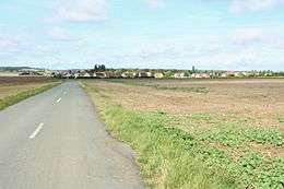
Approach
Population
| Historical population | ||
|---|---|---|
| Year | Pop. | ±% |
| 1793 | 160 | — |
| 1800 | 129 | −19.4% |
| 1806 | 136 | +5.4% |
| 1821 | 139 | +2.2% |
| 1831 | 142 | +2.2% |
| 1836 | 125 | −12.0% |
| 1841 | 128 | +2.4% |
| 1846 | 132 | +3.1% |
| 1851 | 146 | +10.6% |
| 1856 | 153 | +4.8% |
| 1861 | 149 | −2.6% |
| 1866 | 152 | +2.0% |
| 1872 | 155 | +2.0% |
| 1876 | 160 | +3.2% |
| 1881 | 151 | −5.6% |
| 1886 | 169 | +11.9% |
| 1891 | 165 | −2.4% |
| 1896 | 172 | +4.2% |
| 1901 | 154 | −10.5% |
| 1906 | 169 | +9.7% |
| 1911 | 173 | +2.4% |
| 1921 | 153 | −11.6% |
| 1926 | 173 | +13.1% |
| 1931 | 142 | −17.9% |
| 1936 | 129 | −9.2% |
| 1946 | 152 | +17.8% |
| 1954 | 181 | +19.1% |
| 1962 | 190 | +5.0% |
| 1968 | 231 | +21.6% |
| 1975 | 246 | +6.5% |
| 1982 | 272 | +10.6% |
| 1990 | 346 | +27.2% |
| 1999 | 370 | +6.9% |
| 2008 | 484 | +30.8% |
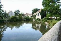
Pond and chapel
See also
References
| Wikimedia Commons has media related to Andelu. |
This article is issued from
Wikipedia.
The text is licensed under Creative Commons - Attribution - Sharealike.
Additional terms may apply for the media files.