Gaillon-sur-Montcient
| Gaillon-sur-Montcient | |
|---|---|
| Commune | |
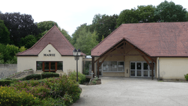 The town hall in Gaillon-sur-Montcient | |
 Gaillon-sur-Montcient Location within Île-de-France region  Gaillon-sur-Montcient | |
| Coordinates: 49°01′35″N 1°53′38″E / 49.0264°N 1.8939°ECoordinates: 49°01′35″N 1°53′38″E / 49.0264°N 1.8939°E | |
| Country | France |
| Region | Île-de-France |
| Department | Yvelines |
| Arrondissement | Mantes-la-Jolie |
| Canton | Les Mureaux |
| Intercommunality | CU Grand Paris Seine et Oise |
| Government | |
| • Mayor | Jean-Luc Gris |
| Area1 | 4.83 km2 (1.86 sq mi) |
| Population (2006)2 | 673 |
| • Density | 140/km2 (360/sq mi) |
| Time zone | UTC+1 (CET) |
| • Summer (DST) | UTC+2 (CEST) |
| INSEE/Postal code | 78261 /78250 |
| Elevation |
22–126 m (72–413 ft) (avg. 91 m or 299 ft) |
|
1 French Land Register data, which excludes lakes, ponds, glaciers > 1 km2 (0.386 sq mi or 247 acres) and river estuaries. 2 Population without double counting: residents of multiple communes (e.g., students and military personnel) only counted once. | |
Gaillon-sur-Montcient is a commune in the Yvelines department in the Île-de-France region in north-central France.
See also
References
| Wikimedia Commons has media related to Gaillon-sur-Montcient. |
This article is issued from
Wikipedia.
The text is licensed under Creative Commons - Attribution - Sharealike.
Additional terms may apply for the media files.