Saint-Sauveur, Haute-Garonne
| Saint-Sauveur | ||
|---|---|---|
| Commune | ||
_Mairie.jpg) | ||
| ||
 Saint-Sauveur Location within Occitanie region  Saint-Sauveur | ||
| Coordinates: 43°44′59″N 1°24′05″E / 43.7497°N 1.4014°ECoordinates: 43°44′59″N 1°24′05″E / 43.7497°N 1.4014°E | ||
| Country | France | |
| Region | Occitanie | |
| Department | Haute-Garonne | |
| Arrondissement | Toulouse | |
| Canton | Villemur-sur-Tarn | |
| Government | ||
| • Mayor (2008–2014) | Philippe Petit | |
| Area1 | 7.04 km2 (2.72 sq mi) | |
| Population (2008)2 | 1,705 | |
| • Density | 240/km2 (630/sq mi) | |
| Time zone | UTC+1 (CET) | |
| • Summer (DST) | UTC+2 (CEST) | |
| INSEE/Postal code | 31516 /31790 | |
| Elevation |
112–175 m (367–574 ft) (avg. 130 m or 430 ft) | |
|
1 French Land Register data, which excludes lakes, ponds, glaciers > 1 km2 (0.386 sq mi or 247 acres) and river estuaries. 2 Population without double counting: residents of multiple communes (e.g., students and military personnel) only counted once. | ||
.svg.png)
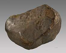
Chondrite EH5 « Saint-Sauveur » - MHNT
Saint-Sauveur is a commune in the Haute-Garonne department in southwestern France.
Population
| Historical population | ||
|---|---|---|
| Year | Pop. | ±% |
| 1962 | 309 | — |
| 1968 | 538 | +74.1% |
| 1975 | 912 | +69.5% |
| 1982 | 1,093 | +19.8% |
| 1990 | 1,159 | +6.0% |
| 1999 | 1,309 | +12.9% |
| 2008 | 1,705 | +30.3% |
Sights
The Church of St Saviour, historical monument.
_Eglise.jpg)
_Eglise_abside.jpg)
_Eglise_Clocher-Mur.jpg)
_Eglise_Cadran_Solaire.jpg)
See also
References
| Wikimedia Commons has media related to Saint-Sauveur (Haute-Garonne). |
This article is issued from
Wikipedia.
The text is licensed under Creative Commons - Attribution - Sharealike.
Additional terms may apply for the media files.