Lespugue
| Lespugue | |
|---|---|
| Commune | |
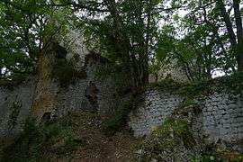 Ruins of the medieval castle | |
 Lespugue Location within Occitanie region  Lespugue | |
| Coordinates: 43°14′00″N 0°40′03″E / 43.2333°N 0.6675°ECoordinates: 43°14′00″N 0°40′03″E / 43.2333°N 0.6675°E | |
| Country | France |
| Region | Occitanie |
| Department | Haute-Garonne |
| Arrondissement | Saint-Gaudens |
| Canton | Saint-Gaudens |
| Government | |
| • Mayor (2008–2014) | Jean-Paul Porthe |
| Area1 | 4.91 km2 (1.90 sq mi) |
| Population (2008)2 | 74 |
| • Density | 15/km2 (39/sq mi) |
| Time zone | UTC+1 (CET) |
| • Summer (DST) | UTC+2 (CEST) |
| INSEE/Postal code | 31295 /31350 |
| Elevation |
281–446 m (922–1,463 ft) (avg. 384 m or 1,260 ft) |
|
1 French Land Register data, which excludes lakes, ponds, glaciers > 1 km2 (0.386 sq mi or 247 acres) and river estuaries. 2 Population without double counting: residents of multiple communes (e.g., students and military personnel) only counted once. | |
Lespugue is a commune in the Haute-Garonne department in southwestern France.
Population
| Historical population | ||
|---|---|---|
| Year | Pop. | ±% |
| 1962 | 135 | — |
| 1968 | 137 | +1.5% |
| 1975 | 108 | −21.2% |
| 1982 | 107 | −0.9% |
| 1990 | 84 | −21.5% |
| 1999 | 83 | −1.2% |
| 2008 | 74 | −10.8% |
See also
References
| Wikimedia Commons has media related to Lespugue. |
This article is issued from
Wikipedia.
The text is licensed under Creative Commons - Attribution - Sharealike.
Additional terms may apply for the media files.