Albiac, Haute-Garonne
| Albiac | ||
|---|---|---|
| Commune | ||
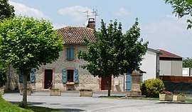 The central square in Albiac | ||
| ||
 Albiac Location within Occitanie region  Albiac | ||
| Coordinates: 43°33′11″N 1°46′53″E / 43.5531°N 1.7814°ECoordinates: 43°33′11″N 1°46′53″E / 43.5531°N 1.7814°E | ||
| Country | France | |
| Region | Occitanie | |
| Department | Haute-Garonne | |
| Arrondissement | Toulouse | |
| Canton | Revel | |
| Intercommunality | Cœur Lauragais | |
| Government | ||
| • Mayor (2014-2020) | Gérard Granouillac | |
| Area1 | 4.71 km2 (1.82 sq mi) | |
| Population (2014)2 | 203 | |
| • Density | 43/km2 (110/sq mi) | |
| Time zone | UTC+1 (CET) | |
| • Summer (DST) | UTC+2 (CEST) | |
| INSEE/Postal code | 31006 /31460 | |
| Elevation |
175–263 m (574–863 ft) (avg. 230 m or 750 ft) | |
|
1 French Land Register data, which excludes lakes, ponds, glaciers > 1 km2 (0.386 sq mi or 247 acres) and river estuaries. 2 Population without double counting: residents of multiple communes (e.g., students and military personnel) only counted once. | ||

Albiac is a commune in the Haute-Garonne department in southwestern France.
Population
| Historical population | ||
|---|---|---|
| Year | Pop. | ±% |
| 1962 | 94 | — |
| 1968 | 116 | +23.4% |
| 1975 | 117 | +0.9% |
| 1982 | 120 | +2.6% |
| 1990 | 137 | +14.2% |
| 1999 | 159 | +16.1% |
| 2008 | 195 | +22.6% |
See also
References
| Wikimedia Commons has media related to Albiac (Haute-Garonne). |
This article is issued from
Wikipedia.
The text is licensed under Creative Commons - Attribution - Sharealike.
Additional terms may apply for the media files.