Laréole
| Laréole | |
|---|---|
| Commune | |
 | |
 Laréole Location within Occitanie region  Laréole | |
| Coordinates: 43°44′20″N 1°01′23″E / 43.7389°N 1.0231°ECoordinates: 43°44′20″N 1°01′23″E / 43.7389°N 1.0231°E | |
| Country | France |
| Region | Occitanie |
| Department | Haute-Garonne |
| Arrondissement | Toulouse |
| Canton | Léguevin |
| Intercommunality | Canton de Cadours |
| Government | |
| • Mayor (2008–2014) | Jean-Luc Gauthe |
| Area1 | 8.88 km2 (3.43 sq mi) |
| Population (2008)2 | 137 |
| • Density | 15/km2 (40/sq mi) |
| Time zone | UTC+1 (CET) |
| • Summer (DST) | UTC+2 (CEST) |
| INSEE/Postal code | 31275 /31480 |
| Elevation |
135–272 m (443–892 ft) (avg. 235 m or 771 ft) |
|
1 French Land Register data, which excludes lakes, ponds, glaciers > 1 km2 (0.386 sq mi or 247 acres) and river estuaries. 2 Population without double counting: residents of multiple communes (e.g., students and military personnel) only counted once. | |
Laréole is a commune in the Haute-Garonne department in southwestern France.
Population
| Historical population | ||
|---|---|---|
| Year | Pop. | ±% |
| 1962 | 121 | — |
| 1968 | 152 | +25.6% |
| 1975 | 146 | −3.9% |
| 1982 | 138 | −5.5% |
| 1990 | 114 | −17.4% |
| 1999 | 122 | +7.0% |
| 2008 | 137 | +12.3% |
Monuments
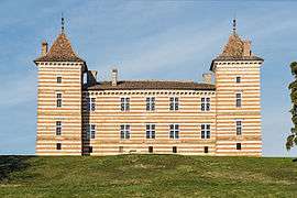
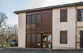 The town hall; The church; The castle
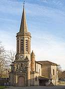 The church Notre-Dame;
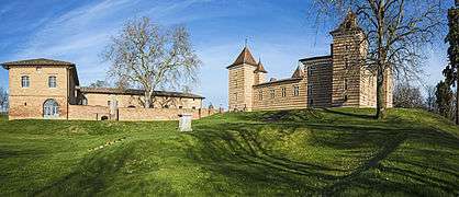 The castle
See also
References
| Wikimedia Commons has media related to Laréole. |
I
This article is issued from
Wikipedia.
The text is licensed under Creative Commons - Attribution - Sharealike.
Additional terms may apply for the media files.