Garidech
| Garidech | ||
|---|---|---|
| Commune | ||
 | ||
| ||
 Garidech Location within Occitanie region  Garidech | ||
| Coordinates: 43°42′32″N 1°33′42″E / 43.7089°N 1.5617°ECoordinates: 43°42′32″N 1°33′42″E / 43.7089°N 1.5617°E | ||
| Country | France | |
| Region | Occitanie | |
| Department | Haute-Garonne | |
| Arrondissement | Toulouse | |
| Canton | Pechbonnieu | |
| Intercommunality | Coteaux du Girou | |
| Government | ||
| • Mayor (2008–2014) | Christian Ciercoles | |
| Area1 | 7.11 km2 (2.75 sq mi) | |
| Population (2008)2 | 1,554 | |
| • Density | 220/km2 (570/sq mi) | |
| Time zone | UTC+1 (CET) | |
| • Summer (DST) | UTC+2 (CEST) | |
| INSEE/Postal code | 31212 /31380 | |
| Elevation |
132–214 m (433–702 ft) (avg. 190 m or 620 ft) | |
|
1 French Land Register data, which excludes lakes, ponds, glaciers > 1 km2 (0.386 sq mi or 247 acres) and river estuaries. 2 Population without double counting: residents of multiple communes (e.g., students and military personnel) only counted once. | ||
.svg.png)
Garidech is a commune in the Haute-Garonne department in southwestern France.
Population
| Historical population | ||
|---|---|---|
| Year | Pop. | ±% |
| 1962 | 305 | — |
| 1968 | 318 | +4.3% |
| 1975 | 380 | +19.5% |
| 1982 | 520 | +36.8% |
| 1990 | 698 | +34.2% |
| 1999 | 954 | +36.7% |
| 2008 | 1,554 | +62.9% |
Transport
Monuments
 Town hall
 War memorial
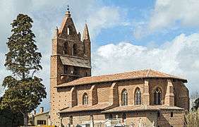 Church Saint-Jean-Baptiste
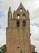 Bel gable
 Primary school
See also
References
| Wikimedia Commons has media related to Garidech. |
This article is issued from
Wikipedia.
The text is licensed under Creative Commons - Attribution - Sharealike.
Additional terms may apply for the media files.