Saint-Geniès-Bellevue
| Saint-Geniès-Bellevue | ||
|---|---|---|
| Commune | ||
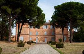 Chateau | ||
| ||
 Saint-Geniès-Bellevue Location within Occitanie region  Saint-Geniès-Bellevue | ||
| Coordinates: 43°41′03″N 1°29′11″E / 43.6842°N 1.4864°ECoordinates: 43°41′03″N 1°29′11″E / 43.6842°N 1.4864°E | ||
| Country | France | |
| Region | Occitanie | |
| Department | Haute-Garonne | |
| Arrondissement | Toulouse | |
| Canton | Pechbonnieu | |
| Intercommunality | Coteaux-Bellevue | |
| Government | ||
| • Mayor (2008–2014) | Émile-Paul Cabrol | |
| Area1 | 3.78 km2 (1.46 sq mi) | |
| Population (2008)2 | 2,166 | |
| • Density | 570/km2 (1,500/sq mi) | |
| Time zone | UTC+1 (CET) | |
| • Summer (DST) | UTC+2 (CEST) | |
| INSEE/Postal code | 31484 /31180 | |
| Elevation |
142–214 m (466–702 ft) (avg. 200 m or 660 ft) | |
|
1 French Land Register data, which excludes lakes, ponds, glaciers > 1 km2 (0.386 sq mi or 247 acres) and river estuaries. 2 Population without double counting: residents of multiple communes (e.g., students and military personnel) only counted once. | ||
.svg.png)
Saint-Geniès-Bellevue is a commune in the Haute-Garonne department in southeast France.
Population
| Historical population | ||
|---|---|---|
| Year | Pop. | ±% |
| 1962 | 372 | — |
| 1968 | 630 | +69.4% |
| 1975 | 1,192 | +89.2% |
| 1982 | 1,452 | +21.8% |
| 1990 | 1,529 | +5.3% |
| 1999 | 1,781 | +16.5% |
| 2008 | 2,166 | +21.6% |
See also
References
| Wikimedia Commons has media related to Saint-Geniès-Bellevue. |
This article is issued from
Wikipedia.
The text is licensed under Creative Commons - Attribution - Sharealike.
Additional terms may apply for the media files.