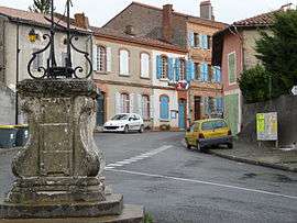
Latrape
| Latrape | |
|---|---|
| Commune | |
 Town hall | |
 Latrape Location within Occitanie region  Latrape | |
| Coordinates: 43°14′45″N 1°17′22″E / 43.2458°N 1.2894°ECoordinates: 43°14′45″N 1°17′22″E / 43.2458°N 1.2894°E | |
| Country | France |
| Region | Occitanie |
| Department | Haute-Garonne |
| Arrondissement | Muret |
| Canton | Auterive |
| Intercommunality | Volvestre |
| Government | |
| • Mayor (2008–2014) | Jean-Louis Séguela |
| Area1 | 19.08 km2 (7.37 sq mi) |
| Population (2008)2 | 346 |
| • Density | 18/km2 (47/sq mi) |
| Time zone | UTC+1 (CET) |
| • Summer (DST) | UTC+2 (CEST) |
| INSEE/Postal code | 31280 /31310 |
| Elevation |
227–369 m (745–1,211 ft) (avg. 354 m or 1,161 ft) |
|
1 French Land Register data, which excludes lakes, ponds, glaciers > 1 km2 (0.386 sq mi or 247 acres) and river estuaries. 2 Population without double counting: residents of multiple communes (e.g., students and military personnel) only counted once. | |
Latrape is a commune in the Haute-Garonne department in southwestern France.
Population
| Historical population | ||
|---|---|---|
| Year | Pop. | ±% |
| 1962 | 233 | — |
| 1968 | 296 | +27.0% |
| 1975 | 222 | −25.0% |
| 1982 | 213 | −4.1% |
| 1990 | 212 | −0.5% |
| 1999 | 297 | +40.1% |
| 2008 | 356 | +19.9% |
See also
References
| Wikimedia Commons has media related to Latrape. |
This article is issued from
Wikipedia.
The text is licensed under Creative Commons - Attribution - Sharealike.
Additional terms may apply for the media files.