Lavalette, Haute-Garonne
| Lavalette | ||
|---|---|---|
| Commune | ||
_Panorama.jpg) | ||
| ||
 Lavalette Location within Occitanie region  Lavalette | ||
| Coordinates: 43°38′19″N 1°35′48″E / 43.6386°N 1.5967°ECoordinates: 43°38′19″N 1°35′48″E / 43.6386°N 1.5967°E | ||
| Country | France | |
| Region | Occitanie | |
| Department | Haute-Garonne | |
| Arrondissement | Toulouse | |
| Canton | Pechbonnieu | |
| Government | ||
| • Mayor (2008–2014) | André Fontés | |
| Area1 | 13.75 km2 (5.31 sq mi) | |
| Population (2008)2 | 624 | |
| • Density | 45/km2 (120/sq mi) | |
| Time zone | UTC+1 (CET) | |
| • Summer (DST) | UTC+2 (CEST) | |
| INSEE/Postal code | 31285 /31590 | |
| Elevation |
155–233 m (509–764 ft) (avg. 221 m or 725 ft) | |
|
1 French Land Register data, which excludes lakes, ponds, glaciers > 1 km2 (0.386 sq mi or 247 acres) and river estuaries. 2 Population without double counting: residents of multiple communes (e.g., students and military personnel) only counted once. | ||
.svg.png)
Lavalette is a commune in the Haute-Garonne department in southwestern France.
Population
| Historical population | ||
|---|---|---|
| Year | Pop. | ±% |
| 1962 | 342 | — |
| 1968 | 355 | +3.8% |
| 1975 | 406 | +14.4% |
| 1982 | 503 | +23.9% |
| 1990 | 531 | +5.6% |
| 1999 | 602 | +13.4% |
| 2008 | 624 | +3.7% |
Monument
_Mairie.jpg) Town hall
Town hall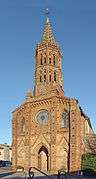 Church Saint-Laurent
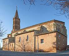 Church Saint-Laurent
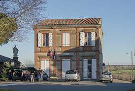 School
See also
References
| Wikimedia Commons has media related to Lavalette (Haute-Garonne). |
This article is issued from
Wikipedia.
The text is licensed under Creative Commons - Attribution - Sharealike.
Additional terms may apply for the media files.