Montoulieu-Saint-Bernard
| Montoulieu-Saint-Bernard | |
|---|---|
| Commune | |
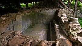 Baths of the Roman villa | |
 Montoulieu-Saint-Bernard Location within Occitanie region  Montoulieu-Saint-Bernard | |
| Coordinates: 43°14′06″N 0°54′33″E / 43.235°N 0.9092°ECoordinates: 43°14′06″N 0°54′33″E / 43.235°N 0.9092°E | |
| Country | France |
| Region | Occitanie |
| Department | Haute-Garonne |
| Arrondissement | Saint-Gaudens |
| Canton | Cazères |
| Intercommunality | Canton d'Aurignac |
| Government | |
| • Mayor (2008–2014) | Camille Sors |
| Area1 | 4.83 km2 (1.86 sq mi) |
| Population (2008)2 | 171 |
| • Density | 35/km2 (92/sq mi) |
| Time zone | UTC+1 (CET) |
| • Summer (DST) | UTC+2 (CEST) |
| INSEE/Postal code | 31386 /31420 |
| Elevation |
276–467 m (906–1,532 ft) (avg. 350 m or 1,150 ft) |
|
1 French Land Register data, which excludes lakes, ponds, glaciers > 1 km2 (0.386 sq mi or 247 acres) and river estuaries. 2 Population without double counting: residents of multiple communes (e.g., students and military personnel) only counted once. | |
Montoulieu-Saint-Bernard is a commune in the Haute-Garonne department of southwestern France.
Population
| Historical population | ||
|---|---|---|
| Year | Pop. | ±% |
| 1962 | 93 | — |
| 1968 | 106 | +14.0% |
| 1975 | 106 | +0.0% |
| 1982 | 111 | +4.7% |
| 1990 | 149 | +34.2% |
| 1999 | 153 | +2.7% |
| 2008 | 171 | +11.8% |
See also
References
| Wikimedia Commons has media related to Montoulieu-Saint-Bernard. |
This article is issued from
Wikipedia.
The text is licensed under Creative Commons - Attribution - Sharealike.
Additional terms may apply for the media files.