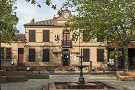
Pechbonnieu
| Pechbonnieu | ||
|---|---|---|
| Commune | ||
 | ||
| ||
 Pechbonnieu Location within Occitanie region  Pechbonnieu | ||
| Coordinates: 43°42′17″N 1°28′03″E / 43.7047°N 1.4675°ECoordinates: 43°42′17″N 1°28′03″E / 43.7047°N 1.4675°E | ||
| Country | France | |
| Region | Occitanie | |
| Department | Haute-Garonne | |
| Arrondissement | Toulouse | |
| Canton | Pechbonnieu | |
| Intercommunality | Coteaux-Bellevue | |
| Government | ||
| • Mayor (2008–2014) | Sabine Geil-Gomez | |
| Area1 | 7.52 km2 (2.90 sq mi) | |
| Population (2008)2 | 3,775 | |
| • Density | 500/km2 (1,300/sq mi) | |
| Time zone | UTC+1 (CET) | |
| • Summer (DST) | UTC+2 (CEST) | |
| INSEE/Postal code | 31410 /31140 | |
| Elevation |
140–208 m (459–682 ft) (avg. 200 m or 660 ft) | |
|
1 French Land Register data, which excludes lakes, ponds, glaciers > 1 km2 (0.386 sq mi or 247 acres) and river estuaries. 2 Population without double counting: residents of multiple communes (e.g., students and military personnel) only counted once. | ||
.svg.png)
Pechbonnieu (Languedocien: Puègbonieu) is a commune in the Haute-Garonne department in southwestern France.
Population
| Historical population | ||
|---|---|---|
| Year | Pop. | ±% |
| 1962 | 542 | — |
| 1968 | 781 | +44.1% |
| 1975 | 1,289 | +65.0% |
| 1982 | 1,535 | +19.1% |
| 1990 | 1,940 | +26.4% |
| 1999 | 2,997 | +54.5% |
| 2008 | 3,775 | +26.0% |
Monuments
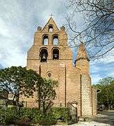 Saint Jacques Church - Bell gable
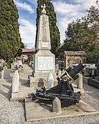 Monument to the Fallen
See also
References
| Wikimedia Commons has media related to Pechbonnieu. |
This article is issued from
Wikipedia.
The text is licensed under Creative Commons - Attribution - Sharealike.
Additional terms may apply for the media files.