Biddu, Jerusalem
| Biddu | |
|---|---|
| Other transcription(s) | |
| • Arabic | بدّو |
 Biddu | |
 Biddu Location of Biddu within Palestine | |
| Coordinates: 31°50′02″N 35°08′43″E / 31.83389°N 35.14528°ECoordinates: 31°50′02″N 35°08′43″E / 31.83389°N 35.14528°E | |
| Palestine grid | 164/137 |
| Governorate | Jerusalem |
| Government | |
| • Type | Municipality |
| Elevation[1] | 837 m (2,746 ft) |
| Population (2006) | |
| • Jurisdiction | 6,368 |
| Name meaning | "Biddu", personal name[2] |
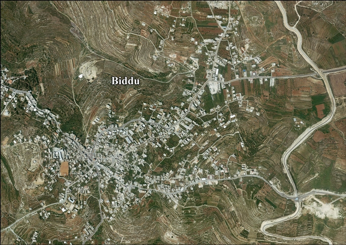
Biddu (Arabic: بدّو) is a Palestinian town in the Jerusalem Governorate, located 6 kilometers northwest of Jerusalem in the West Bank. According to the Palestinian Central Bureau of Statistics, the town had a population of 6,368 in 2006.[3] Biddu is at an altitude of 806m to 834m. Giv'on HaHadashah lies 2 km east of Biddu.
Location
Biddu is located (horizontally) 10.1 kilometers (6.3 mi) north-west of Jerusalem. It is bordered by Beit Iksa to the east, Beit Ijza to the north, Al Qubeiba to the west, and Beit Surik to the south.[1]
History
Bagatti suggested that several buildings in the town are from the 12th century. South-west of the centre is the ruined wali of Sheikh Abu Talal, which might have been a Crusader church.[4][5]
Ottoman era
In the Ottoman tax records of the 1500s, Biddu was located in the nahiya of Jerusalem.[6]
In 1738 Richard Pococke noted the village, as he passed between Biddu and Beit Surik.[7]
In 1838 Edward Robinson noted the village during his travels in the area.[8][9] It was described as a Muslim village, located in the Beni Malik area, west of Jerusalem.[10]
In May 1863 Victor Guérin visited the village, called Biddou. He described it as being situated on a very high plateau, with some 150 inhabitants. Some houses seemed very old.[11]
Socin, citing an official Ottoman village list compiled around 1870, noted that Biddu had 70 houses and a population of 247, though the population count included men, only. It was further noted that “the village was once more important, also it has a cistern carved in the rock. The Crusader road from Ramle to Nabi Samwil ran through here.“[12] Hartmann found that Biddu had 71 houses.[13]
In 1883 the Palestine Exploration Fund's Survey of Western Palestine described it as "a village on a rocky hill, with a well to the north east. It is of moderate size."[14]
In 1896 the population of Biddu was estimated to be about 546 persons.[15]
British Mandate era
In the 1922 census of Palestine conducted by the British Mandate authorities, Biddu had a population 252, all Muslims.[16] This had increased in the 1931 census to 399, still all Muslim, in 88 houses.[17]
In the 1945 statistics the population of Biddu consisted of 520 Muslims[18] and the land area was 5,392 dunams, according to an official land and population survey.[19] Of this, 334 dunams were designated for plantations and irrigable land, 2,258 for cereals,[20] while 19 dunams were built-up areas.[21]
Jordanian era
On the night of 19 April 1948 the village was attacked by the Palmach.[22][23] The attacking force was commanded by Yosef Tabenkin, based in Jerusalem. They were later to become the Harel Brigade of the Israeli army. The attack came from Beit Surik which had been captured earlier that night. Biddu was subjected to a short bombardment from a Davidka after which Palmach sappers entered the village and demolished its houses.[24][25]
In the wake of the 1948 Arab–Israeli War, and after the 1949 Armistice Agreements, Biddu came under Jordanian rule from 1948 until 1967.
In 1961, the population of Biddu was 1,444.[26]
1967-present
After the Six-Day War in 1967, Biddu has been under Israeli occupation. The population in the 1967 census conducted by the Israeli authorities was 1,259, of whom 567 originated from the Israeli territory.[27]
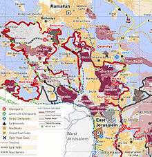
After the 1995 accords, 24.8% of Biddus land was classified as Area B, while the remaining 75.2% is Area C.[28]
Israel has confiscated about 627 dunams of Biddus land for the Israeli settlement of Har Adar (Giv’at HaRadar), and 186 dunams for Giv’on Ha’hadasha.[29]
Enclave
Biddu along with 9 other Palestinian villages, Beit Duqqu, Beit 'Anan, Beit Surik, Qatanna, al-Qubeiba, Beit Ijza, Kharayib Umm al Lahimand and at Tira form the "Biddu enclave" which, according to Tanya Reinhart, are imprisoned behind a wall, cut off from their orchards and farmlands that are being seized in order to form the real estate reserves of the Jerusalem Corridor and to create a territorial continuity with Giv'at Ze'ev.[30] The enclave will be linked to Ramallah by underpasses and a road that is fenced on both sides. From the "Biddu enclave" Palestinians will travel along a fenced road that passes under a bypass road to Bir Nabala enclave, then on a second underpass under Bypass Road 443 to Ramallah.[31]
In 2004, initially peaceful demonstrations against the separation barrier in Biddu turned violent when the IDF cleared the area.[32] has become a focal point for non-violent resistance to the process of incorporating Palestinian lands into Israeli settlements.[33] Biddu villagers promote the use of their bodies to hinder bulldozing of their terrain, and recourse to arms or violence is forbidden.[30]
Attempts to have "women only" protests, to avoid conflict, have met with defeat. In one demonstration by Israeli and local women activists in April 2004, a protest by 70 women brandishing signs and singing was broken up by tear gas, stun grenades, and mounted police.[33] Diaa' A-Din 'Abd al-Karim Ibrahim Abu 'Eid was shot dead by gunfire during an anti-barrier demonstration on 18 April 2004.[34] Muhammad Fadel Hashem Rian and Zakaria Mahmoud 'Eid Salem were shot dead during anti-barrier demonstrations on 26 February 2004 at Beit Ijaz (a satellite village of Biddu).[34]
Footnotes
- 1 2 Biddu Town Profile, ARIJ, p. 4
- ↑ Palmer, 1881, p. 287
- ↑ Projected Mid -Year Population for Jerusalem Governorate by Locality 2004- 2006 Archived February 7, 2012, at the Wayback Machine. Palestinian Central Bureau of Statistics.
- ↑ Pringle, 1993, p. 160
- ↑ Pringle, 1997, p. 33
- ↑ Toledano, 1984, p. 291, has Biddu at location 31°50′10″N. 35°08′30″E
- ↑ Pococke, 1745, vol II, p. 49, cited in Robinson and Smith, 1841, vol 3, p. 65
- ↑ Robinson and Smith, 1841, vol 2, pp. 133, 141
- ↑ Robinson and Smith, 1841, vol 3, p. 66
- ↑ Robinson and Smith, 1841, vol 3, Appendix 2, p. 124
- ↑ Guérin, 1868, p. 362
- ↑ Socin, 1879, p. 148
- ↑ Hartmann, 1883, p. 118
- ↑ Conder and Kitchener, 1883, SWP III, p. 17
- ↑ Schick, 1896, p. 126
- ↑ Barron, 1923, Table VII, Sub-district of Jerusalem, p. 15
- ↑ Mills, 1932, p. 39
- ↑ Government of Palestine, Department of Statistics, 1945, p. 24
- ↑ Government of Palestine, Department of Statistics. Village Statistics, April, 1945. Quoted in Hadawi, 1970, p. 56
- ↑ Government of Palestine, Department of Statistics. Village Statistics, April, 1945. Quoted in Hadawi, 1970, p. 102
- ↑ Government of Palestine, Department of Statistics. Village Statistics, April, 1945. Quoted in Hadawi, 1970, p. 152
- ↑ Morris, 1987, p.112.
- ↑ Morris, 2004, p. 235
- ↑ Allon, Yigal (1970) The Making of Israel's Army. Vallentine, Mitchell - London. ISBN 0-853-03027-8. pp.194,195
- ↑ Morris, 2004, p. 345
- ↑ Government of Jordan, Department of Statistics, 1964, p. 23
- ↑ Perlmann, Joel (November 2011 – February 2012). "The 1967 Census of the West Bank and Gaza Strip: A Digitized Version" (PDF). Levy Economics Institute. Retrieved 24 January 2018.
- ↑ Biddu Town Profile, ARIJ, p. 17
- ↑ Biddu Town Profile, ARIJ, p. 18
- 1 2 Reinhart, 2006, p. 202
- ↑ OCHA Archived November 12, 2005, at the Wayback Machine.
- ↑ Conal Urquhart, 'Israelis kill two villagers in barrier protests,' The Guardian 27 February 2004:'Yesterday Ziad Mansoor, 23, from Biddu, said he had witnessed the shooting dead of Zacharia Eid, a father of three from a nearby village. Mr Eid had been arrested by Israelis and put in a jeep, but managed to run away, at which point he was shot, according to Mr Mansoor. He said they had been protesting because the separation barrier would ruin the future of the villages. "We will be cut off from everything we need to have for a normal life," he said. . .Periodically, a cry would go up among Palestinians that someone had been injured and an ambulance would go to the rescue. One paramedic said that at least 11 people had been wounded by live ammunition and 14 by rubber bullets.'.
- 1 2 Ben Lynfield,'A West Bank town tries to protest the wall nonviolently,' Christian Science Monitor, 6 May 2004:'what sets apart the Biddu demonstrations is that they are driven by Palestinians directly affected by the fence who espouse nonviolence as a tactic amid the shootings, suicide bombings, and calls for revenge that have characterized three-plus years of conflict.'
- 1 2 B'Tselem West Bank Statistics
Bibliography
- Barron, J. B., ed. (1923). Palestine: Report and General Abstracts of the Census of 1922. Government of Palestine.
- Conder, C.R.; Kitchener, H. H. (1883). The Survey of Western Palestine: Memoirs of the Topography, Orography, Hydrography, and Archaeology. 3. London: Committee of the Palestine Exploration Fund.
- Government of Jordan, Department of Statistics (1964). First Census of Population and Housing. Volume I: Final Tables; General Characteristics of the Population (PDF).
- Government of Palestine, Department of Statistics (1945). Village Statistics, April, 1945.
- Guérin, V. (1868). Description Géographique Historique et Archéologique de la Palestine (in French). 1: Judee, pt. 1. Paris: L'Imprimerie Nationale.
- Hadawi, S. (1970). Village Statistics of 1945: A Classification of Land and Area ownership in Palestine. Palestine Liberation Organization Research Centre.
- Hartmann, M. (1883). "Die Ortschaftenliste des Liwa Jerusalem in dem türkischen Staatskalender für Syrien auf das Jahr 1288 der Flucht (1871)". Zeitschrift des Deutschen Palästina-Vereins. 6: 102–149.
- McCown, C. (1921). "Muslim Shrines in Palestine". AASOR (=Annual of the American Schools of Oriental Research). 2–3: 47–79. (pp. 57-59)
- Mills, E., ed. (1932). Census of Palestine 1931. Population of Villages, Towns and Administrative Areas. Jerusalem: Government of Palestine.
- Morris, B. (1987). The Birth of the Palestinian refugee problem, 1947-1949. Cambridge University Press. ISBN 0-521-33028-9.
- Morris, B. (2004). The Birth of the Palestinian Refugee Problem Revisited. Cambridge University Press. ISBN 978-0-521-00967-6.
- Palmer, E. H. (1881). The Survey of Western Palestine: Arabic and English Name Lists Collected During the Survey by Lieutenants Conder and Kitchener, R. E. Transliterated and Explained by E.H. Palmer. Committee of the Palestine Exploration Fund.
- Pococke, R. (1745). A description of the East, and some other countries. 2. London: Printed for the author, by W. Bowyer.
- Pringle, Denys (1993). The Churches of the Crusader Kingdom of Jerusalem: Volume I A-K (excluding Acre and Jerusalem). Cambridge University Press. ISBN 0 521 39036 2.
- Pringle, Denys (1997). Secular buildings in the Crusader Kingdom of Jerusalem: an archaeological Gazetteer. Cambridge University Press. ISBN 0521 46010 7.
- Reinhart, T. (2006). The Road Map to Nowhere: Israel/Palestine Since 2003. London; New York: Verso. ISBN 1-84467-076-7.
- Robinson, E.; Smith, E. (1841). Biblical Researches in Palestine, Mount Sinai and Arabia Petraea: A Journal of Travels in the year 1838. 2. Boston: Crocker & Brewster.
- Robinson, E.; Smith, E. (1841). Biblical Researches in Palestine, Mount Sinai and Arabia Petraea: A Journal of Travels in the year 1838. 3. Boston: Crocker & Brewster.
- Schick, C. (1896). "Zur Einwohnerzahl des Bezirks Jerusalem". Zeitschrift des Deutschen Palästina-Vereins. 19: 120–127.
- Socin, A. (1879). "Alphabetisches Verzeichniss von Ortschaften des Paschalik Jerusalem". Zeitschrift des Deutschen Palästina-Vereins. 2: 135–163.
- Toledano, E. (1984). "The Sanjaq of Jerusalem in the Sixteenth Century: Aspects of Topography and Population". Archivum Ottomanicum. 9: 279–319.
External links
- Welcome To Biddu
- Survey of Western Palestine, Map 17: IAA, Wikimedia commons
- West Bank's vulnerable olive growers, Al Jazeera
- Biddu Town (Fact Sheet), Applied Research Institute–Jerusalem (ARIJ)
- Biddu Town Profile, ARIJ
- Biddu aerial photo, ARIJ
- Locality Development Priorities and Needs in Biddu, ARIJ
