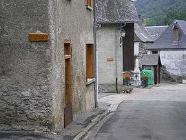
Portet-d'Aspet
| Portet-d'Aspet | |
|---|---|
| Commune | |
 | |
 Portet-d'Aspet Location within Occitanie region  Portet-d'Aspet | |
| Coordinates: 42°56′29″N 0°51′58″E / 42.9414°N 0.8661°ECoordinates: 42°56′29″N 0°51′58″E / 42.9414°N 0.8661°E | |
| Country | France |
| Region | Occitanie |
| Department | Haute-Garonne |
| Arrondissement | Saint-Gaudens |
| Canton | Bagnères-de-Luchon |
| Intercommunality | Trois Vallées |
| Government | |
| • Mayor (2008–2014) | Jean Dubuc |
| Area1 | 13.93 km2 (5.38 sq mi) |
| Population (2008)2 | 73 |
| • Density | 5.2/km2 (14/sq mi) |
| Time zone | UTC+1 (CET) |
| • Summer (DST) | UTC+2 (CEST) |
| INSEE/Postal code | 31431 /31160 |
| Elevation |
680–1,574 m (2,231–5,164 ft) (avg. 860 m or 2,820 ft) |
|
1 French Land Register data, which excludes lakes, ponds, glaciers > 1 km2 (0.386 sq mi or 247 acres) and river estuaries. 2 Population without double counting: residents of multiple communes (e.g., students and military personnel) only counted once. | |
Portet-d'Aspet is a commune in the Haute-Garonne department in southwestern France.
Population
| Historical population | ||
|---|---|---|
| Year | Pop. | ±% |
| 1962 | 112 | — |
| 1968 | 114 | +1.8% |
| 1975 | 68 | −40.4% |
| 1982 | 65 | −4.4% |
| 1990 | 75 | +15.4% |
| 1999 | 67 | −10.7% |
| 2008 | 73 | +9.0% |
See also
References
| Wikimedia Commons has media related to Portet-d'Aspet. |
This article is issued from
Wikipedia.
The text is licensed under Creative Commons - Attribution - Sharealike.
Additional terms may apply for the media files.