West Sussex
| West Sussex | |
|---|---|
| County | |
 West Sussex in England | |
| Sovereign state |
|
| Country |
|
| Region | South East England |
| Established |
1974 (Local Government Act 1972) |
| Ceremonial county | |
| Area | 1,991 km2 (769 sq mi) |
| • Ranked | 30th of 48 |
| Population (mid-2017 est.) | 852,400 |
| • Ranked | 27th of 48 |
| Density | 428/km2 (1,110/sq mi) |
| Ethnicity |
96.6% White 1.7% S.Asian |
| Non-metropolitan county | |
| County council |
 West Sussex County Council http://www.westsussex.gov.uk/ |
| Executive | Conservative |
| Admin HQ | Chichester |
| Area | 1,991 km2 (769 sq mi) |
| • Ranked | 21st of 27 |
| Population | 852,400 |
| • Ranked | 9th of 27 |
| Density | 428/km2 (1,110/sq mi) |
| ISO 3166-2 | GB-WSX |
| ONS code | 45 |
| NUTS | UKJ24 |
 Unitary County council area Districts of West Sussex | |
| Districts | |
| Members of Parliament | 8 members |
| Time zone | Greenwich Mean Time (UTC) |
| • Summer (DST) | British Summer Time (UTC+1) |
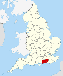
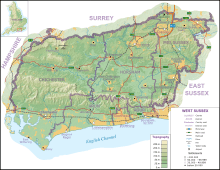
West Sussex is a county in the south of England, bordering East Sussex (with Brighton and Hove) to the east, Hampshire to the west and Surrey to the north, and to the south the English Channel.
West Sussex is based on the western part of the historic county of Sussex, which was formerly a medieval kingdom. With an area of 1,991 square kilometres (769 sq mi) and a population of over 800,000, West Sussex is a ceremonial county, with a Lord Lieutenant and a High Sherriff. Chichester in the south-west is the county town and only city in West Sussex, with the largest towns being Crawley, Worthing and Horsham.
West Sussex has a range of scenery, including wealden, downland and coastal. The highest point of the county is Blackdown, at 280 metres (919 ft). It has a number of stately homes including Goodwood, Petworth House and Uppark and also castles such as Arundel Castle and Bramber Castle. Over half the county is protected countryside, offering walking, cycling and other recreational opportunities.[1]
History
Although the name Sussex, derived from the Old English 'Sūþsēaxe' ('South Saxons'), dates from the Saxon period between AD 477 to 1066, the history of human habitation in Sussex goes back to the Old Stone Age.[2] The oldest hominin remains known in Britain were found at Eartham Pit, Boxgrove.[3][4] Sussex has been occupied since those times and has succumbed to various invasions and migrations throughout its long history.[2] Prehistoric monuments include the Devil's Jumps, a group of Bronze Age burial mounds, and the Iron Age Cissbury Ring and Chanctonbury Ring hill forts on the South Downs.
The Roman period saw the building of Fishbourne Roman Palace and rural villas such as Bignor Roman Villa together with a network of roads including Stane Street, the Chichester to Silchester Way and the Sussex Greensand Way. The Romans used the Weald for iron production on an industrial scale.[5]
The foundation of the Kingdom of Sussex is recorded by the Anglo-Saxon Chronicle for the year AD 477; it says that Ælle arrived at a place called Cymenshore in three ships with his three sons and killed or put to flight the local inhabitants. The foundation story is regarded as somewhat of a myth by most historians, although the archaeology suggests that Saxons did start to settle in the area in the late 5th century.[6][7] The Kingdom of Sussex was absorbed into Wessex as an earldom and became the county of Sussex.
With its origins in the kingdom of Sussex, the later county of Sussex was traditionally divided into six units known as rapes. By the 16th century, the three western rapes were grouped together informally, having their own separate Quarter Sessions. These were administered by a separate county council from 1888, the county of Sussex being divided for administrative purposes into the administrative counties of East and West Sussex. In 1974, West Sussex was made a single ceremonial county with the coming into force of the Local Government Act 1972. At the same time a large part of the eastern rape of Lewes (the Mid Sussex district which includes the towns of Haywards Heath, Burgess Hill and East Grinstead) was transferred into West Sussex.
Provision for paupers
Until 1834 provision for the poor and destitute in West Sussex was made at parish level. From 1835 until 1948 eleven Poor Law Unions, each catering for several parishes, took on the job.[8]
Settlements
Most settlements in West Sussex are either along the south coast or in Mid Sussex, near the M23/A23 corridor. The town of Crawley is the largest in the county with an estimated population of 106,600.[9] The coastal settlement of Worthing closely follows with a population of 104,600.[9] The seaside resort of Bognor Regis and market town Horsham are both large towns. Chichester, the county town, has a cathedral and city status, and is situated not far from the border with Hampshire. Other conurbations of a similar size are Burgess Hill, East Grinstead and Haywards Heath in the Mid Sussex district, Littlehampton in the Arun district, and Lancing, Southwick and Shoreham in the Adur district. Much of the coastal town population is part of the Brighton/Worthing/Littlehampton conurbation.
Rustington and Southwater are the next largest settlements in the county. There are several more towns in West Sussex, although they are of similar size to other villages. The smaller towns of the county are Arundel, Midhurst, Petworth, Selsey and Steyning. The larger villages are Billingshurst, Copthorne, Crawley Down, Cuckfield, Henfield, Hassocks, Hurstpierpoint, Lindfield, Pulborough and Storrington. The current total population of the county makes up 1.53% of England's population.
Geography
Physical geography
- (See also: Geology of West Sussex)
West Sussex is bordered by Hampshire to the west, Surrey to the north and East Sussex to the east. The English Channel lies to the south. The area has been formed from Upper Jurassic and Lower Cretaceous rock strata, part of the Weald–Artois Anticline. The eastern part of this ridge, the Weald of Kent, Sussex and Surrey has been greatly eroded, with the chalk surface removed to expose older Lower Cretaceous rocks of the Wealden Group.[10] In West Sussex the exposed rock becomes older towards the north of the county with Lower Greensand ridges along the border with Surrey including the highest point of the county at Blackdown. Erosion of softer sand and clay strata has hollowed out the basin of the Weald leaving a north facing scarp slope of the chalk which runs east and west across the whole county, broken only by the valleys of the River Arun and River Adur.[11] In addition to these two rivers which drain most of the county a winterbourne, the River Lavant, flows intermittently from springs on the dip slope of the chalk downs north of Chichester.[12]
The county makes up 1.52% of the total land of England, making it the 30th largest county in the country.[13]
| Bognor Regis | ||||||||||||||||||||||||||||||||||||||||||||||||||||||||||||
|---|---|---|---|---|---|---|---|---|---|---|---|---|---|---|---|---|---|---|---|---|---|---|---|---|---|---|---|---|---|---|---|---|---|---|---|---|---|---|---|---|---|---|---|---|---|---|---|---|---|---|---|---|---|---|---|---|---|---|---|---|
| Climate chart (explanation) | ||||||||||||||||||||||||||||||||||||||||||||||||||||||||||||
| ||||||||||||||||||||||||||||||||||||||||||||||||||||||||||||
| ||||||||||||||||||||||||||||||||||||||||||||||||||||||||||||
Climate
West Sussex is the sunniest county in the United Kingdom, according to Met Office records. Over the last 29 years it has averaged 1902 hours of sunshine per year.[15] Sunshine totals are highest near the coast with Bognor Regis often having the highest in mainland England, including a total of 2237 hours in 1990. Mean annual temperature for southern coastal counties is around 11 °C. The coldest month, January, has mean daily minimum temperatures of around 3 °C near the coast and lower inland. July tends to be the warmest month when mean daily maxima tend to be around 20 °C. A maximum temperature of 35.4 °C occurred at North Heath, Pulborough on 26 June 1976. Coastal high temperatures are often moderated by cooler sea breezes.[16]
Monthly rainfall tends to be highest in autumn and early winter and lowest in the summer months, with July often being the driest month. There is less rainfall from summer convective showers and thunderstorms than in inland areas. The county can suffer both from localised flooding caused by heavy rainfall and from water shortages caused by prolonged periods of below average rainfall. Winter rainfall is needed to recharge the chalk aquifers from which much of the water supply is drawn.[16]
Land economy
West Sussex developed distinctive land uses along with its neighbours in the weald. The Landrace cattle transformed into Sussex cattle and Sussex chickens emerged about the time of the Roman conquest.[17] Some of the earliest evidence of horses in Britain has been found at Boxgrove, dated to 500,000 BC. Viticulture is a part of the economy, with wineries producing mainly sparkling wine of varied quality.[18]
Communications and transport
The M23 Motorway runs from London to the south of Crawley. The A23 and A24 roads run from London to Brighton and Worthing respectively with the A29 a little further west ending in Bognor Regis. Other major roads are the A272 which runs east to west through the middle of the county and the A27 which does the same but closer to the coast. The A259 is a local alternate route to the A27 in the eastern coastal strip.
Gatwick Airport, which handled over 33 million passengers and had over 250,000 aircraft movements in 2011, is located within the borders of Crawley, and is the second largest airport in the United Kingdom. There is also a considerably smaller local airport at Shoreham and a grass airfield handling light aircraft and helicopters at Goodwood. There are three main railway routes: the Brighton Main Line, the Arun Valley Line and the West Coastway Line. The Portsmouth Direct Line serves and occasionally enters the westernmost part of West Sussex, although it has no railway stations in the county.
National politics
Since the 2015 general election, West Sussex has been represented entirely by Conservative MPs.
- Arundel & South Downs - Nick Herbert, Conservative
- Bognor Regis & Littlehampton - Nick Gibb, Conservative
- Chichester - Andrew Tyrie, Conservative
- Crawley - Henry Smith, Conservative
- Horsham - Jeremy Quin, Conservative
- Mid Sussex - Nicholas Soames, Conservative
- Worthing East & Shoreham - Tim Loughton, Conservative
- Worthing West - Peter Bottomley, Conservative
Local government
County Council
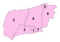
West Sussex County Council (WSCC) is the authority that governs the non-metropolitan county of West Sussex. The county contains 7 district and borough councils ( Adur, Arun, Chichester, Crawley, Horsham, Mid Sussex and Worthing), and 159 town, parish and neighbourhood councils.
West Sussex County Council has 71 councillors; the majority of them being Conservative. There are 46 Conservative councillors, 10 UK Independence Party, 8 Liberal Democrats, 6 Labour Party councillors and 1 Independent councillor.[20] The Chief Executive and his team of Executive Directors are responsible for the day-to-day running of the council.
West Sussex County Council is based at County Hall, Chichester and provides a large range of services including education, social services, fire and rescue, libraries, trading standards, town and country planning, refuse disposal and consumer services.
West Sussex Youth Cabinet
The West Sussex Youth Cabinet is a group of local representatives and four UK Youth Parliament (UKYP) representatives, who are elected by young people in West Sussex.[21] The Youth Cabinet represents the views of the young people West Sussex at county level. Elections for the Youth Cabinet and UKYP in West Sussex run every year in March.
Places of interest
Nature and zoos
- Chichester Harbour
- Pagham Harbour - A protected area of wetland that is an important feeding ground for birds.
- RSPB Pulborough Brooks
- Selsey Bill
- South Downs Way - a long distance footpath
- Stansted Park
- St Leonard's Forest
- Tilgate Park
- Wakehurst Place
- Warnham Local Nature Reserve, a 92-acre site with visitor centre[22]
- WWT Arundel (a nature reserve of the Wildfowl and Wetlands Trust)
Castles, houses and other buildings
- Arundel Castle
- Barnham Windmill
- Bramber Castle
- Christ's Hospital, an old charitable school notable for its archaic uniforms and picturesque campus.
- Goodwood House and Goodwood Motor Circuit
- High Salvington windmill
- Hurstpierpoint College, a public school, notable for its substantial Sussex flint buildings and large campus.
- Lancing College, a public school, notable for its substantial Sussex sandstone chapel and large campus.
- Seaford College, a public school known for its large campus
- Nymans house and gardens, a National Trust property near Handcross, Haywards Heath
- Petworth House and deer park.
- Queen Victoria Hospital, East Grinstead, where Sir Archibald McIndoe carried out reconstructive surgery for burns patients during the Second World War.
- Sackville College, a Jacobean almshouse in East Grinstead
- Shipley Windmill, (no longer open to the public).
- Standen, East Grinstead
- Uppark, a 17th-century mansion high on the South Downs.
Religious buildings
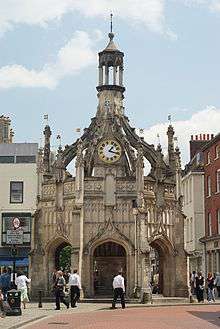
The Cathedral Church of the Holy Trinity, otherwise called Chichester Cathedral, is the seat of the Anglican Bishop of Chichester. It was founded as a cathedral in 1075, when the seat of the bishop was moved from Selsey Abbey.[23] The cathedral has architecture in both the Norman and the Gothic styles, and has been called by the architectural historian Nikolaus Pevsner "the most typical English Cathedral".[24] The Cathedral Church of Our Lady and St Philip Howard in Arundel is the Roman Catholic cathedral of the Diocese of Arundel and Brighton. Built in French Gothic style and dedicated in 1873 as the Catholic parish church of Arundel, it was not designated a cathedral until the foundation of the diocese in 1965.[25]
Bosham Church is partly of Saxon construction and is shown on the Bayeaux Tapestry as the local church of late Saxon and Danish kings of England.[26] Many other Saxon and early Norman have survived in the county with little alteration including the Church of St Mary the Blessed Virgin, Sompting, an 11th-century Anglo-Saxon church with a Rhenish helm unique in England and St. Nicholas' Church, Worth, a 10th-century church in Worth, Crawley. Some Anglican churches and many of the numerous nonconformist chapels in the county have been converted to residential use. Cittaviveka is a Buddhist monastery in Chithurst.
Museums
- Worthing Museum & Art Gallery
- Amberley Museum & Heritage Centre
- Manor Cottage[27]
- Steyning Museum[28]
- Tangmere Military Aviation Museum[29]
- Horsham Museum
- Weald and Downland Open Air Museum of historic buildings at Singleton
The arts
Pallant House Gallery in Chichester houses one of the most significant collections of 20th-century British art outside London. It includes a substantial body of early and mid-20th-century work bequeathed by Walter Hussey and many later works donated by Sir Colin St John 'Sandy' Wilson.
Worthing Museum and Art Gallery houses a large collection of Georgian and Victorian costume. The Cass Sculpture Foundation has an outdoor sculpture park at Goodwood.
Economy and demography
This is a table of trend of regional gross value added of West Sussex at current basic prices published by Office for National Statistics with figures in millions of British Pounds Sterling.[30]
| Year | Regional gross value added[31] | Agriculture[32] | Industry[33] | Services[34] |
|---|---|---|---|---|
| 1995 | 8,564 | 208 | 2,239 | 6,116 |
| 2000 | 10,576 | 162 | 2,545 | 7,869 |
| 2003 | 12,619 | 185 | 2,520 | 9,915 |
Significant companies in the county include Rolls-Royce Motor Cars, a substantial employer near Chichester. Gatwick Airport, with associated airlines including British Airways and Virgin Atlantic, is a major source of direct and indirect employment. Thales Group also has a presence in the county.
The table below shows the population change up to the 2011 census, contrasting the previous census. It also shows the proportion of residents in each district reliant upon lowest income and/or joblessness benefits, the national average proportion of which was 4.5% as at August 2012, the year for which latest datasets have been published. It can be seen that the most populous district of West Sussex is Arun containing the towns of Arundel, Bognor Regis and Littlehampton:
| Unit | JSA or Inc. Supp. claimants (August 2012) % of 2011 population | JSA and Income Support claimants (August 2001) % of 2001 population | Population (April 2011) | Population (April 2001) |
|---|---|---|---|---|
| West Sussex | 2.7% | 5.1% | 806,892 | 753,614 |
| Ranked by district | ||||
| Crawley | 3.8% | 5.3% | 106,597 | 99,744 |
| Worthing | 3.6% | 6.7% | 104,640 | 97,568 |
| Adur | 3.2% | 6.3% | 61,182 | 59,627 |
| Arun | 3.0% | 6.4% | 149,518 | 140,759 |
| Chichester | 2.3% | 4.8% | 113,794 | 106,450 |
| Horsham | 1.9% | 3.3% | 131,301 | 122,088 |
| Mid Sussex | 1.6% | 3.6% | 139,860 | 127,378 |
Education
West Sussex has a comprehensive education system, with a mix of county-maintained secondary schools and academies and over twenty independent senior schools. In addition primary education is provided through a mix of around 240 infant, junior, primary, first and middle schools.
Colleges include The College of Richard Collyer, Central Sussex College, Northbrook College and The Weald School.
Independent schools in the county include Christ's Hospital, whose students wear Tudor style uniform, Seaford College, Lancing College and Hurstpierpoint College.
Tertiary education is provided by the University of Chichester and Chichester College.
Sport
At least 40 sports are active in West Sussex. Sussex was the first First-Class cricket county formed in 1839 and was a cradle for club cricket.[36][37] Sussex is home to Fontwell Park Racecourse.[38] The county has one Football League club located in Crawley, that is Crawley Town F.C..[39]
See also
References
- ↑ West Sussex County Council: Leisure & Tourism Archived 6 December 2006 at the Wayback Machine.
- 1 2 Armstrong. History of Sussex. Chapter 2. The first Inhabitants
- ↑ "SSSI Citation — Eartham Pit" (PDF). Natural England. Retrieved 4 November 2012.
- ↑ A History of Britain, Richard Dargie (2007), p. 8–9
- ↑ H. Cleere & D. Crossley, Iron industry of the Weald (2nd edn, Merton Priory Press, Cardiff, 1995), 79-84; based on work by H. F. Cleere, including 'Some operating parameters for Roman ironworks' Inst Archaeol. Bull. 13 (1976), 233-46.
- ↑ Anglo-Saxon Chronicle Parker MS. 477AD.
- ↑ Welch, M.G. (1992). Anglo-Saxon England. English Heritage. ISBN 0-7134-6566-2. pg 9
- ↑ "West Sussex County Council: Poor Law Records". Retrieved 15 February 2015.
- 1 2 Office for National Statistics. "Census 2011 result shows increase in population of the South East". Retrieved 13 December 2012.
- ↑ Gallois R.W. & Edmunds M.A. (4th Ed 1965), The Wealden District, British Regional Geology series, British Geological Survey, ISBN 0-11-884078-9
- ↑ Mantell, Gideon Algernon; Jones (1857). The Wonders of Geology. I. Thomas Rupert (7th ed.). London: Henry G. Bohn. p. 371. Retrieved 27 October 2013.
- ↑ Marsh, Terry; Hannaford, Jamie (2008). "UK Hydrometric Register" (PDF). Natural Environment Research Council. p. 122. ISBN 978-0-9557672-2-7. Archived from the original (PDF) on 5 October 2013. Retrieved 27 October 2013.
- ↑ Barrow, Mandy. "Project Britain British Life and Culture". Project Britain. Mandy Barrow. Retrieved 24 September 2017.
- ↑ "Bognor Regis Climate". Met Office. Retrieved 8 December 2013.
- ↑ "Bognor Regis the sunniest spot in Britain". The Daily Telegraph. London. 28 December 2011. Retrieved 28 December 2011.
- 1 2 "Southern England: climate". Met Office. Archived from the original on 5 June 2011. Retrieved 29 October 2013.
- ↑ Hobson, Jeremy and Lewis, Celia. Choosing & Raising Chickens: The complete guide to breeds and welfare. Daniel and Charles Publishing. London. 2009. p 94-95
- ↑ "VisitSussex: Sussex Wine & Beer". Retrieved 22 February 2015.
- ↑ "BBC NEWS – Election 2010 – South East". BBC News.
- ↑ West Sussex County Council: Councillors Archived 6 January 2007 at the Wayback Machine.
- ↑ "Could you be a West Sussex youth MP? - News". Worthing Herald. Retrieved 29 May 2013.
- ↑ "Warnham Local Nature Reserve". Retrieved 14 March 2015.
- ↑ Tim Tatton-Brown and John Crook, The English Cathedral, New Holland (2002), ISBN 1-84330-120-2
- ↑ Nikolaus Pevsner and Ian Nairn, Buildings of England: Sussex, Penguin Books (1965) (now published by Yale University Press) ISBN 0-300-09677-1
- ↑ Hudson, T. P. (ed) (1997). "A History of the County of Sussex: Volume 5 Part 1 – Arundel Rape (South-Western Part) including Arundel. Arundel Rape: South-Western part". Victoria County History of Sussex. British History Online. pp. 7–9. Retrieved 28 April 2011.
- ↑ Salzman, L. F. (ed) (1953). "A History of the County of Sussex: Volume 4 – The Rape of Chichester. Bosham". Victoria County History of Sussex. British History Online. pp. 182–188. Retrieved 30 August 2012.
- ↑ "Southwick (Sussex) Society - The Manor Cottage".
- ↑ "Steyning Museum Home Page".
- ↑ "Welcome to Tangmere".
- ↑ Archived 28 July 2011 at the Wayback Machine.
- ↑ Components may not sum to totals due to rounding
- ↑ includes hunting and forestry
- ↑ includes energy and construction
- ↑ includes financial intermediation services indirectly measured
- ↑ Key Statistics: Population; Quick Statistics: Economic indicators. (2011 census and 2001 census) Retrieved 27 February 2015.
- ↑ "West Sussex Info: Cricket clubs, cricket leagues and village cricket in West Sussex". Retrieved 22 February 2015.
- ↑ "Sussex CCC was the first First-Class County formed in 1839". Retrieved 22 February 2015.
- ↑ "Cheltenham named Racegoers Club Racecourse of the Year".
- ↑ "Official Website of the Red Devils - Crawley Town FC".
External links
- Images of West Sussex at the English Heritage Archive
- West Sussex at Curlie (based on DMOZ)
Neighbouring counties | |
|---|---|