Milton, Portsmouth
| Milton | |
|---|---|
 Milton Milton shown within Hampshire | |
| Population | 14,111 |
| OS grid reference | SZ 66433 99895 |
| Unitary authority | |
| Ceremonial county | |
| Region | |
| Country | England |
| Sovereign state | United Kingdom |
| Post town | PORTSMOUTH |
| Postcode district | PO4 |
| Dialling code | 023 |
| Police | Hampshire |
| Fire | Hampshire |
| Ambulance | South Central |
| EU Parliament | South East England |
| UK Parliament | |
Milton is primarily a residential area of the English city of Portsmouth, Hampshire, England, on the south eastern side of Portsea Island. Milton is bordered on the eastern coast of Portsea Island by Langstone Harbour, with Eastney to the south-east, Southsea to the south-west, Baffins to the north and Fratton to the north-west.
The name 'Milton' has Saxon origins, meaning "middle village", as it was located midway between the larger Saxon village of Froddington (now Fratton) and the sea.[1]
Milton was originally a small village on Portsea Island, surrounded by arable and garden farmland until it was swallowed up by the eastward expansion of Portsmouth in the early 20th century.
Politically, Milton is represented as Milton Ward in Portsmouth City Council. Milton Ward is part of the Portsmouth South UK Parliament Constituency.[2] The population of the Milton Ward of Portsmouth at the 2011 Census was 14,111.[3]
History

On the south eastern side of Portsea Island, Milton still retains somewhat of a village ambience and can boast two large public parks; Milton Park and Bransbury Park, both of which were former farms. Milton was originally a small village, surrounded by arable and market garden farmland until it was swallowed up by the expansion of Portsmouth across Portsea Island in the late 19th and early 20th centuries. A canal was built through Milton in the early 19th century, forming part of the Portsmouth and Arundel Canal.
Today's Milton Park now occupies farmland previously known as Purnell Farm, which became part of the Milton Farm estate owned by the Goldsmith family in 1808. Purnell Farm was then later renamed Middle Farm by the Goldsmith's.[5] In 1911, James Goldsmith died and his Milton Farm estate was split up. Portsmouth Council bought Middle Farm and created Milton Park in 1912.[1] Some members of the Goldsmith family are buried just across the road from Milton Park in St James churchyard on Milton Road. One of the original Middle Farm buildings remains; the thatched barn, which has been extended and is now the home of the Portsmouth Players amateur dramatic society.
Milton Locks, in the far east of Milton at the end of the eponymous Locksway Road, is located at the Langstone Harbour entrance of the abandoned Portsmouth and Arundel Canal which began operations in 1822. Little now remains of the old lock gates, wooden as they were, although the infrastructure is still evident. There are several pubs located along the former canal path, partly delineating its route towards Landport where it ended at the eponymously named Arundel Street. Traces of the canal survive further into central Portsmouth, as the railway line from Fratton to Portsmouth and Southsea railway station, runs along the earlier canal bed. This can be most easily seen from a street called Canal Walk, just off Fratton Bridge.
Part of the former Portsmouth and Arundel Canal was located directly south of Middle Farm (later Milton Park) which was built across Portsea Island to Landport. When the canal closed in the middle of the nineteenth century, the section in Milton was filled in to form a new main road along the route of the canal, and was named Goldsmith Avenue after the local land owning Goldsmith family.
Bransbury Park was previously Eastney Farm up to 1911, part of the Goldsmith's estate until it was purchased by Portsmouth council. Eastney Farm and surrounding marshland at Eastney were drained and combined to form Bransbury Park.[1] Presently, Bransbury Park offers squash and netball courts as well as several football pitches for local Sunday League clubs and schools football. There is also a permanent miniature railway track located in the centre of Bransbury Park for use by Portsmouth Model Engineering Society members. In more recent years, a small skatepark has been erected at the eastern end of Bransbury Park.
The parade of shops in Eastney Road opposite Bransbury Park is popularly known as "Milton Market"; the local sub-post office's name is officially "Milton Market". A traditional family-owned confectionery shop named "Gilbert's" has been trading in Milton Market since it first opened over a century ago.[6]
St James' Hospital, an institution for the treatment of mental health, first opened in 1874 on what was then called Asylum Road, now named Locksway Road. Until the 1960s, St James' Hospital possessed a small Home Farm, with orchards, cornfields and a piggery. Nowadays largely built on and with the former cornfields now occupied by the Langstone Campus of the University of Portsmouth, the remaining hospital grounds are still quite extensive and include a cricket field complete with clubhouse. Another part of the grounds has been secured as a third public park for the area, St James' Green, on which community events are held and further features such as a children's Nature Trail are to be incorporated.
In 1884, an infectious diseases hospital named Priorsdean opened near the village. Priorsdean later became part of St Mary's Hospital, one of the city's main hospitals which opened at Milton in 1898. In the late 1990s, the eastern section of St Mary's Hospital (which incorporated Priorsdean) was redeveloped and became Miltoncross Academy school and a small housing development. In the early 2000s, the majority of the remaining St Mary's Hospital site was also redeveloped into housing, with many of St Mary's hospital services transferring to Queen Alexandra Hospital in Cosham, Portsmouth. St Mary's Hospital continues today as the St Mary's NHS Treatment Centre, which has a minor injuries and illnesses unit.
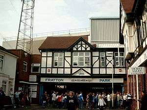
In 1898, Sir John Brickwood, owner of the Portsmouth-based Brickwood Brewery, and five fellow directors of the "Portsmouth Football & Athletic Company" (now Portsmouth F.C.) purchased a potato field located near Goldsmith Avenue, Milton. During 1898-1899, the early Portsmouth Football Club built their modest football ground and named it "Fratton Park". Although not actually built in the district of Fratton, which is one mile to the north-west, the football ground name was deliberately chosen to persuade users of the more familiar nearby Fratton railway and tram station that the new football ground was within an easy walking distance. The Fratton Park football ground was completed and opened on 15 August 1899. The eastern 'end' of Fratton Park was named 'The Milton End' after the Milton district in which the stadium is actually built.
On the eastern edge of Portsea Island which borders Langstone Harbour, there is an area now known as Milton Common, once formerly a tidal inlet known as Milton Lake (and even earlier, "Felder Lake" from which the current Velder Avenue's name is derived). Milton Common is reclaimed land, formed by landfill tipping in the 1950s through to 1970 into the large area of tidal mudflats that was previously Milton Lake. The perimeter of the former Milton Lake can still be traced on a modern map, as the A2030 Eastern Road borders it to the north and Moorings Way road to the south. The site has an informal network of footpaths with the eastern footpath running alongside Langstone Harbour forming part of the Solent Way. There are three freshwater lakes; Frog Lake, Duck Lake and Swan Lake, home to many aquatic and avian species. The land is still settling and the cavities of Milton Common make ideal homes for foxes and other wildlife.
Moorings Way - the road bounding the southern edge of Milton Common - was so called because of the large number of houseboats that were moored alongside the edge of the former Milton Lake. Many people displaced in the 1940s Blitz found refuge along the north shore of Eastney Lake and round into Milton Lake, almost a shanty town. Mostly consisting of makeshift houseboats, converted railway carriages and fisherman huts, many of these homes, lacking the basic amenities of electricity and plumbed water supplies, survived into the 1960s until they were cleared.
The number of local pubs in Milton continues to decline. In 2011, a pub named The Traveller's Joy, which had been on the same site since the early 1800s and featured on early maps of Milton village, was closed and was demolished. The Traveller's Joy was located near the junction of Milton Road and Priory Crescent, near to Milton Park and Fratton Park. A veterinary surgery and flats were built and opened on the site. Also in 2011, a well known public house located on the Y junction of Milton Road, Eastney Road and Goldsmith Avenue called The White House was closed. In 2013, The White House was demolished and replaced with a terrace of new family homes which was later opened and named as White House Terrace, with an appropriate white painted frontage. In 2017, only three pubs remained on Milton Road; Mr Pickwick, The Milton Arms and The Brewer’s Arms. The Brewer's Arms closed in the summer of 2017 and remains derelict, with plans to demolish the building to make way for flats. Mr Pickwick closed in early 2018 and is currently under development.
Governance
Milton is a Portsmouth City Council ward within the Portsmouth South parliamentary constituency. It was formed for the 2002 Portsmouth City Council election as the successor of the pre-2002 Milton ward.
| Election | Councillor | Councillor | Councillor | |||
|---|---|---|---|---|---|---|
| 2002 | Caroline Scott (Lib Dem) | Alexander Bentley (Lib Dem) | Nigel Sizer (Lib Dem) | |||
| 2003 | Caroline Scott (Lib Dem) | Alexander Bentley (Lib Dem) | Gerald Vernon-Jackson (Lib Dem) | |||
| 2004 | Caroline Scott (Lib Dem) | Alexander Bentley (Lib Dem) | Gerald Vernon-Jackson (Lib Dem) | |||
| 2006 | Caroline Scott (Lib Dem) | Alexander Bentley (Lib Dem) | Gerald Vernon-Jackson (Lib Dem) | |||
| 2007 | Caroline Scott (Lib Dem) | Alexander Bentley (Lib Dem) | Gerald Vernon-Jackson (Lib Dem) | |||
| 2008 | Caroline Scott (Lib Dem) | Sarah Dinenage (Con) | Gerald Vernon-Jackson (Lib Dem) | |||
| 2010 | Caroline Scott (Lib Dem) | Sarah Dinenage (Con) | Gerald Vernon-Jackson (Lib Dem) | |||
| 2011 | Caroline Scott (Lib Dem) | Sarah Dinenage (Con)[7] | Gerald Vernon-Jackson (Lib Dem) | |||
| Sarah Dinenage (Lib Dem)[8] | ||||||
| 2012 | Caroline Scott (Lib Dem) | Will Purvis (Lib Dem) | Gerald Vernon-Jackson (Lib Dem) | |||
| 2014 | Ben Dowling (Lib Dem) | Will Purvis (Lib Dem) | Gerald Vernon-Jackson (Lib Dem) | |||
| 2015 | Ben Dowling (Lib Dem) | Will Purvis (Lib Dem) | Gerald Vernon-Jackson (Lib Dem) | |||
| 2016 | Ben Dowling (Lib Dem) | Will Purvis (Lib Dem) | Gerald Vernon-Jackson (Lib Dem) | |||
| 2018 | Ben Dowling (Lib Dem) | Will Purvis (Lib Dem) | Gerald Vernon-Jackson (Lib Dem) | |||
indicates seat up for election.
References
- 1 2 3 Lambert, Tim. "A History of Milton, Portsmouth". localhistories.org. Retrieved 8 October 2017.
- ↑ https://www.portsmouth.gov.uk/ext/the-council/voting-and-elections/electoral-areas-in-portsmouth
- ↑ "Portsmouth Ward population 2011". Retrieved 18 October 2015.
- ↑ http://www.localhistories.org/milton.html
- ↑ http://historyinportsmouth.co.uk/places/milton-village.htm
- ↑ http://mentmore.webplus.net/page79.html?ifrm_28=page80.html
- ↑ https://www.bbc.co.uk/news/uk-england-dorset-17845169
- ↑ https://www.bbc.co.uk/news/uk-england-dorset-17845169