Benton Township, Monroe County, Indiana
| Benton Township | |
|---|---|
| Township | |
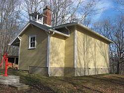 Honey Creek School, a historic site in the township | |
 Location in Monroe County | |
| Coordinates: 39°14′46″N 86°25′30″W / 39.24611°N 86.42500°WCoordinates: 39°14′46″N 86°25′30″W / 39.24611°N 86.42500°W | |
| Country |
|
| State |
|
| County | Monroe |
| Government | |
| • Type | Indiana township |
| Area | |
| • Total | 56.61 sq mi (146.6 km2) |
| • Land | 54.92 sq mi (142.2 km2) |
| • Water | 1.69 sq mi (4.4 km2) 2.99% |
| Elevation[1] | 830 ft (253 m) |
| Population (2010) | |
| • Total | 3,358 |
| • Density | 61.1/sq mi (23.6/km2) |
| Time zone | UTC-5 (Eastern (EST)) |
| • Summer (DST) | UTC-4 (EDT) |
| ZIP codes | 46151, 47401, 47408, 47468 |
| Area code(s) | 812, 930 |
| GNIS feature ID | 453106 |
| Website | bentontownshiptrustee.org/ |
Benton Township is one of eleven townships in Monroe County, Indiana, United States. As of the 2010 census, its population was 3,358 and it contained 1,716 housing units.[2]
History
Benton Township was established in 1833.[3] It was named for Thomas Hart Benton, a U.S. Senator from Missouri.[4] Benton township was divided into Marion township to the north and Benton township to the south in August 1845.[5] The current township was formed in January 1916 when Marion township and Benton township merged back together to form a single township.[6]
Honey Creek School was listed on the National Register of Historic Places in 1978.[7]
Geography
According to the 2010 census, the township has a total area of 56.61 square miles (146.6 km2), of which 54.92 square miles (142.2 km2) (or 97.01%) is land and 1.69 square miles (4.4 km2) (or 2.99%) is water.[2]
Unincorporated towns
Cemeteries
The township trustee is responsible for four cemeteries: Fleener/Richardson, Stepp, Brock, and Taylor/McGowan/Frye.
Major highways
Lakes
- Beanblossom Lake
- Cherry Lake
- Lazy Lake
School districts
- Monroe County Community School Corporation
Political districts
- Indiana's 9th congressional district
- State House District 60
- State Senate District 40
References
- "Benton Township, Monroe County, Indiana". Geographic Names Information System. United States Geological Survey. Retrieved 2009-09-27.
- United States Census Bureau 2008 TIGER/Line Shapefiles
- IndianaMap
- ↑ "US Board on Geographic Names". United States Geological Survey. October 25, 2007. Retrieved 2017-05-09.
- 1 2 "Population, Housing Units, Area, and Density: 2010 - County -- County Subdivision and Place -- 2010 Census Summary File 1". United States Census. Retrieved 2013-05-10.
- ↑ History of Lawrence and Monroe Counties, Indiana: Their People, Industries, and Institutions. B.F. Bowen. 1914. p. 404.
- ↑ Blanchard, Charles (1884). Counties of Morgan, Monroe and Brown, Indiana: Historical and Biographical. F.A. Battey & Company. p. 531.
- ↑ Monroe County Timeline
- ↑ Community: Benton Township Volunteer Fire Department
- ↑ National Park Service (2010-07-09). "National Register Information System". National Register of Historic Places. National Park Service.
External links
- Indiana Township Association
- United Township Association of Indiana
- City-Data.com page for Benton Township
Places adjacent to Benton Township, Monroe County, Indiana | |
|---|---|