Mean center of the United States population

Map showing changes to the mean center of population for the United States, 1790–2010 (US Census Bureau)[1]
The center of the US population, 13th census, near Bloomington, Indiana
The center of the US population, 13th census (1910), near Bloomington, Indiana

The mean center of the United States population is determined by the United States Census Bureau from the results of each national census. The Bureau defines it as follows:

The concept of the center of population as used by the U.S. Census Bureau is that of a balance point. The center of population is the point at which an imaginary, weightless, rigid, and flat (no elevation effects) surface representation of the 50 states (or 48 conterminous states for calculations made prior to 1960) and the District of Columbia would balance if weights of identical size were placed on it so that each weight represented the location on one person. More specifically, this calculation is called the mean center of population.[2]

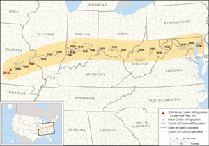
After moving roughly 600 mi (966 km) west by south during the 19th century, the shift in the mean center of population during the 20th century was less pronounced, moving 324 mi (521 km) west and 101 mi (163 km) south. Nearly 79% of the overall southerly movement happened between 1950 and 2000.

Location information since 1790
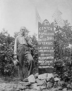
US Census County Location description[2] Decimal coordinates[2]
1790 Kent County, Maryland[lower-alpha 1] 23 miles east of Baltimore 39°16′30″N 76°11′12″W / 39.27500°N 76.18667°W / 39.27500; -76.18667
1800 Howard County, Maryland 18 miles west of Baltimore 39°16′06″N 76°56′30″W / 39.26833°N 76.94167°W / 39.26833; -76.94167
1810 Loudoun County, Virginia 40 miles northwest by west of Washington, D.C. 39°11′30″N 77°37′12″W / 39.19167°N 77.62000°W / 39.19167; -77.62000
1820 Hardy County, West Virginia[lower-alpha 2] 16 miles east of Moorefield 39°05′42″N 78°33′00″W / 39.09500°N 78.55000°W / 39.09500; -78.55000
1830 Grant County, West Virginia[lower-alpha 2] 19 miles west-southwest of Moorefield 38°57′54″N 79°16′54″W / 38.96500°N 79.28167°W / 38.96500; -79.28167
1840 Upshur County, West Virginia[lower-alpha 2] 16 miles south of Clarksburg 39°02′00″N 80°18′00″W / 39.03333°N 80.30000°W / 39.03333; -80.30000
1850 Wirt County, West Virginia[lower-alpha 2] 23 miles southeast of Parkersburg 38°59′00″N 81°19′00″W / 38.98333°N 81.31667°W / 38.98333; -81.31667
1860 Pike County, Ohio 20 miles south by east of Chillicothe 39°00′24″N 82°48′48″W / 39.00667°N 82.81333°W / 39.00667; -82.81333
1870 Highland County, Ohio 48 miles east by north of Cincinnati 39°12′00″N 83°35′42″W / 39.20000°N 83.59500°W / 39.20000; -83.59500
1880 Boone County, Kentucky 8 miles west by south of Cincinnati 39°04′08″N 84°39′40″W / 39.06889°N 84.66111°W / 39.06889; -84.66111
1890 Decatur County, Indiana 20 miles east of Columbus 39°11′56″N 85°32′53″W / 39.19889°N 85.54806°W / 39.19889; -85.54806
1900 Bartholomew County, Indiana 6 miles southeast of Columbus 39°09′36″N 85°48′54″W / 39.16000°N 85.81500°W / 39.16000; -85.81500
1910 Monroe County, Indiana in the city of Bloomington 39°10′12″N 86°32′20″W / 39.17000°N 86.53889°W / 39.17000; -86.53889
1920 Owen County, Indiana 8 miles south-southeast of Spencer 39°10′21″N 86°43′15″W / 39.17250°N 86.72083°W / 39.17250; -86.72083
1930 Greene County, Indiana 3 miles northeast of Linton 39°03′45″N 87°08′06″W / 39.06250°N 87.13500°W / 39.06250; -87.13500
1940 Sullivan County, Indiana 2 miles southeast by east of Carlisle 38°56′54″N 87°22′35″W / 38.94833°N 87.37639°W / 38.94833; -87.37639
1950 Richland County, Illinois[lower-alpha 3]
Clay County, Illinois[lower-alpha 4]
8 miles north-northwest of Olney
3 miles northeast of Louisville
38°50′21″N 88°09′33″W / 38.83917°N 88.15917°W / 38.83917; -88.15917
38°48′15″N 88°22′08″W / 38.80417°N 88.36889°W / 38.80417; -88.36889
1960 Clinton County, Illinois[lower-alpha 5] 6.5 miles northwest of Centralia 38°35′58″N 89°12′35″W / 38.59944°N 89.20972°W / 38.59944; -89.20972
1970 St. Clair County, Illinois 5 miles east-southeast of Mascoutah 38°27′47″N 89°42′22″W / 38.46306°N 89.70611°W / 38.46306; -89.70611
1980 Jefferson County, Missouri 0.3 mile west of DeSoto 38°08′13″N 90°34′26″W / 38.13694°N 90.57389°W / 38.13694; -90.57389
1990 Crawford County, Missouri 9.7 miles southeast of Steelville 37°52′20″N 91°12′55″W / 37.87222°N 91.21528°W / 37.87222; -91.21528
2000 Phelps County, Missouri 2.8 miles east of Edgar Springs 37°41′49″N 91°48′34″W / 37.696987°N 91.809567°W / 37.696987; -91.809567[3]
2010 Texas County, Missouri 2.7 miles northeast of Plato 37°31′03″N 92°10′23″W / 37.517534°N 92.173096°W / 37.517534; -92.173096[4]
2017 (estimated) Wright County, Missouri 11.3 miles southwest of Plato 37°24′42″N 92°23′40″W / 37.411764°N 92.394544°W / 37.411764; -92.394544[5]
2020 (projected) Wright County, Missouri 8.5 miles north-northeast of Hartville 37°22′18″N 92°28′43″W / 37.371644°N 92.478542°W / 37.371644; -92.478542[5]
  1. In the first census (1790), the mean population center was about 7.4 miles northwest by west of Chestertown, Maryland.[3]
  2. 1 2 3 4 The mean population centers of 1820, 1830, 1840 and 1850 were in Virginia at the time of their censuses, before West Virginia's split from Virginia in 1863.[3]
  3. Computation method used until 1950.
  4. Current computation method.
  5. The addition of Alaska and Hawaii to the union in 1959 contributed to moving the mean center of population about 2 miles (3.2 km) farther south and about 10 miles (16 km) farther west in the 1960 census.[2]

The 19.6-mile (31.5 km) shift projected for the 2010–2020 period would be the shortest centroid movement since the Great Depression intercensal period of 1930–1940.[5]

See also

References

  1. Mean Center of Population for the United States: 1790 to 2010 from the U.S. Census Bureau website.
  2. 1 2 3 4 Centers of population computation, a U.S. Census Bureau publication, issued March 2011.
  3. 1 2 3 2000 U.S. Population Centered in Phelps County, Mo., a U.S. Census Bureau press release.
  4. Centers of Population for the 2010 Census, U.S. Census Bureau.
  5. 1 2 3 Alex Zakrewsky, Principal Planner/Data Manager, Middlesex County New Jersey Office of Planning.
This article is issued from Wikipedia. The text is licensed under Creative Commons - Attribution - Sharealike. Additional terms may apply for the media files.