Smithville-Sanders, Indiana
| Smithville-Sanders, Indiana | |
|---|---|
| Census-designated place | |
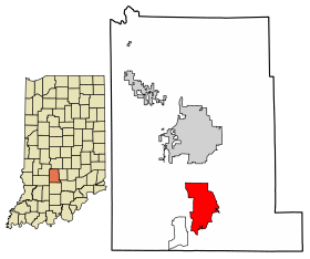 Location of Smithville-Sanders in Monroe County, Indiana. | |
| Coordinates: 39°03′35″N 86°30′39″W / 39.05972°N 86.51083°WCoordinates: 39°03′35″N 86°30′39″W / 39.05972°N 86.51083°W | |
| Country | United States |
| State | Indiana |
| County | Monroe |
| Township | Clear Creek, Perry |
| Area[1] | |
| • Total | 10.720 sq mi (27.76 km2) |
| • Land | 10.720 sq mi (27.76 km2) |
| • Water | 0 sq mi (0 km2) |
| Elevation[2] | 715 ft (218 m) |
| Population (2010)[1] | |
| • Total | 3,184 |
| • Density | 300/sq mi (110/km2) |
| Time zone | UTC-5 (Eastern (EST)) |
| • Summer (DST) | UTC-4 (EDT) |
| ZIP code | 47401 |
| Area code(s) | 812 & 930 |
| GNIS feature ID | 2583471 |
Smithville-Sanders is a census-designated place (CDP) encompassing the communities of Smithville and Sanders in Monroe County, Indiana, United States.[3] Its population was 3,184 as of the 2010 census.[1]
Geography
Smithville-Sanders is located at 39°03′35″N 86°30′39″W / 39.0596963°N 86.5107719°W. According to the U.S. Census Bureau, the CDP has an area of 10.720 square miles (27.76 km2), all of it land.[1]
Demographics
| Historical population | |||
|---|---|---|---|
| Census | Pop. | %± | |
| U.S. Decennial Census[4] | |||
References
- 1 2 3 4 "2010 Census Gazetteer Files - Places: Indiana". U.S. Census Bureau. Retrieved March 25, 2016.
- ↑ "US Board on Geographic Names". United States Geological Survey. October 25, 2007. Retrieved 2017-05-09.
- ↑ "Smithville-Sanders Census Designated Places". Geographic Names Information System. United States Geological Survey.
- ↑ "Census of Population and Housing". Census.gov. Retrieved June 4, 2016.
This article is issued from
Wikipedia.
The text is licensed under Creative Commons - Attribution - Sharealike.
Additional terms may apply for the media files.