Aligarh
| Aligarh | |
|---|---|
| City | |
 | |
 Aligarh Location in Uttar Pradesh, India  Aligarh Aligarh (India) | |
| Coordinates: 27°53′N 78°05′E / 27.88°N 78.08°ECoordinates: 27°53′N 78°05′E / 27.88°N 78.08°E | |
| Country | India |
| State | Uttar Pradesh |
| Division | Aligarh |
| District | Aligarh |
| Founded by | koil-Dor Rajputs |
| Government | |
| • Type | Municipal corporation |
| • Body | Aligarh Nagar Nigam |
| • Mayor | Mohammad Furqan, (Bahujan Samaj Party) |
| Elevation | 178 m (584 ft) |
| Population (2017)[1] | |
| • Total | 1,240,896 |
| • Rank | 55 |
| Time zone | UTC+5:30 (IST) |
| PIN | 202001,202002 |
| Telephone code | 0571 |
| Vehicle registration | UP-81 |
| Website |
aligarh |
Aligarh ( (![]()
History
Before the 18th century, Aligarh was known as Kol. The history of the district up until the 12th century is obscure.[3]
Some time before the Muslim conquest, Kol was held by the Dor Rajputs. At the time of Mahmud of Ghazni, the chief of the Dors was Hardatta of Baran. Statues of Buddha and other Buddhist remains have been found in excavations where the citadel of Koil stood, indicating a Buddhist influence. Hindu remains indicate that the citadel probably had a Hindu temple after the Buddhist temple. In 1194, Qutb-ud-din Aibak marched from Delhi to Kol, "one of the most celebrated fortresses of Hind". Qutb-ud-din Aibak appointed Hisam-ud-din Ulbak as the first Muslim governor of Kol.
Kol is mentioned in Ibn Battuta's Rihla, when Ibn Battuta along with 15 ambassadors representing Ukhaantu Khan, emperor of the Mongol Chinese Yuan dynasty, travelled to Kol city en route to the coast at Cambay (in Gujarat) in 1341.[4] According to Battuta, it would appear that the district was then in a very disturbed state since the escort of the Emperor's embassy had to assist in relieving Jalali from an attacking body of Hindus and lost an officer in the fight. Ibn Batuta calls Kol "a fine town surrounded by mango groves". From these same groves the environs of Kol would appear to have acquired the name Sabzabad or "the green country".
In the reign of Akbar, Kol was made a Sirkar and included the dasturs of Marahra, Kol ba Haveli, Thana Farida and Akbarabad. Akbar and Jahangir visited Kol on hunting expeditions. Jahangir clearly mentions the forest of Kol, where he killed wolves.[3]
During the time of Ibrahim Lodhi, Muhammad, son of 'Umar, was the governor of Kol. He built a fort at Kol and named the city Muhammadgarh, after himself, in 1524–25. Sabit Khan, who was then the governor of this region, of Farrukh Siyar and Muhammad Shah, rebuilt the old Lodhi fort and named the town after himself: Sabitgarh.
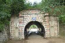
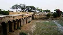
The Jat ruler, Surajmal, with help from Jai Singh of Jaipur and the Muslim army, occupied the fort of Koil. Koil was renamed Ramgarh and finally, when a Shia commander, Najaf Khan, captured it, he gave it its present name of Aligarh. Aligarh Fort (also called Aligarh Qila), as it stands today, was built by French engineers under the command of French officers Benoît de Boigne and Perron.[3]
Battle of Aligarh (1803)
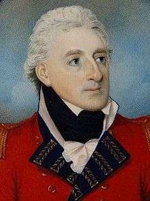
The Battle of Aligarh was fought on 1 September 1803 during the Second Anglo-Maratha War (1803–1805) at Aligarh Fort. The British 76th Regiment, now known as the Duke of Wellington's Regiment besieged the fort, which was under the control of the French officer Perron, and established British rule. In 1804, the Aligarh district was formed by the union of the second, third and fourth British divisions with the addition of Anupshahr from Muradabad and Sikandra Rao from Etawa. On 1 August 1804, Claude Russell was appointed the first Collector of the new district.[5]
Administration
Aligarh district is divided into five tehsils, namely Kol Tehsil, Khair Tehsil, Atrauli, Gabhana and Iglas. These tehsils are further divided into 12 blocks.
The city is administered by Nagar Nigam Aligarh (Municipal Corporation), which is responsible for performing civic administrative functions administered by Mayor and Municipal Commissioner (PCS Officer). Infrastructure development of the city is looked after by the Aligarh Development Authority (ADA) administered by Divisional Commissioner (Chairman) and Vice-Chairman (PCS Officer).
Aligarh is the headquarters of Aligarh Police Range and Aligarh Division. A DIG looks after Aligarh for legal condition and law; a Commissioner looks for four district of Aligarh Division(Aligarh, Etah, Hathras, Kasganj).
Geography
Location
Aligarh is located at the coordinates 27°53′N 78°05′E / 27.88°N 78.08°E.[6] It has an elevation of approximately 178 metres (587 feet). The city is in the middle portion of the doab, the land between the Ganges and the Yamuna rivers. The G.T. Road passes through. It is 134 km from capital of India via NH-91.
Climate
Aligarh has a monsoon-influenced humid subtropical climate, typical of north-central India. Summers start in April and are hot with temperatures peaking in May. The average temperature range is 28–38 °C (82–100 °F). The monsoon season starts in late June, continuing till early October, bringing high humidity. Aligarh gets most of its annual rainfall of 800 millimetres (31 in) during these months. Temperatures then decrease, and winter sets in December, and continues till February. Temperatures range between 5–11 °C (41–52 °F). Winters in Aligarh are generally mild, but 2011–12 experienced the lowest temperature of 1 °C. The fog and cold snaps are extreme.
| Climate data for Aligarh | |||||||||||||
|---|---|---|---|---|---|---|---|---|---|---|---|---|---|
| Month | Jan | Feb | Mar | Apr | May | Jun | Jul | Aug | Sep | Oct | Nov | Dec | Year |
| Record high °C (°F) | 30.7 (87.3) |
33.3 (91.9) |
41.7 (107.1) |
44.8 (112.6) |
47.5 (117.5) |
46.7 (116.1) |
44.5 (112.1) |
42.1 (107.8) |
40.2 (104.4) |
41.7 (107.1) |
36.1 (97) |
32.8 (91) |
47.5 (117.5) |
| Average high °C (°F) | 20.6 (69.1) |
23.6 (74.5) |
30.0 (86) |
36.8 (98.2) |
40.1 (104.2) |
39.3 (102.7) |
34.6 (94.3) |
33.2 (91.8) |
33.8 (92.8) |
33.0 (91.4) |
28.3 (82.9) |
22.5 (72.5) |
31.3 (88.3) |
| Average low °C (°F) | 7.4 (45.3) |
9.5 (49.1) |
14.1 (57.4) |
20.1 (68.2) |
24.5 (76.1) |
26.6 (79.9) |
26.0 (78.8) |
25.4 (77.7) |
23.8 (74.8) |
18.8 (65.8) |
12.9 (55.2) |
8.5 (47.3) |
18.1 (64.6) |
| Record low °C (°F) | 0.0 (32) |
1.7 (35.1) |
3.9 (39) |
10.9 (51.6) |
15.5 (59.9) |
18.6 (65.5) |
19.9 (67.8) |
19.9 (67.8) |
14.8 (58.6) |
11.0 (51.8) |
2.9 (37.2) |
1.2 (34.2) |
0.0 (32) |
| Average precipitation mm (inches) | 15.2 (0.598) |
13.9 (0.547) |
8.5 (0.335) |
8.8 (0.346) |
21.0 (0.827) |
68.5 (2.697) |
217.7 (8.571) |
247.4 (9.74) |
104.1 (4.098) |
31.4 (1.236) |
4.2 (0.165) |
11.0 (0.433) |
751.8 (29.598) |
| Average rainy days | 1.5 | 1.4 | 1.0 | 0.9 | 2.2 | 4.1 | 10.2 | 11.6 | 5.2 | 1.4 | 0.5 | 0.8 | 40.7 |
| Source: India Meteorological Department (record high and low up to 2010)[7][8] | |||||||||||||
Demographics
The 2011 census[9] showed the Aligarh city had a population of 874,408. Males outnumbered females 461,772 to 412,636. The literacy rate was 68.52%.
Economy
The city is an agricultural trade centre.[10] Agricultural product processing and manufacturing are important.[11]
Aligarh is an important business centre of Uttar Pradesh and is most famous for its lock industry. Aligarh locks are exported across the world. In 1870, Johnson & Co. was the first English lock firm in Aligarh. In 1890, the company initiated production of locks on a small scale here.[12]
Aligarh is famous for brass hardware and sculpture. Today, the city holds thousands of manufacturers, exporters and suppliers involved in the brass, bronze, iron and aluminium industries.
Aligarh is a big centre of zinc dye- casting. There are thousands of pneumatic hot chamber die casting machines. But many exporters have adopted latest technology and have installed fully automatic, computerised hot chamber machines. Indian Dye-casting Industries at Sasni Gate Area is the most renowned manufacturer in this line and they are capable of meeting international quality norms.
Harduaganj Thermal Power Station (also referred as Kasimpur Power House) is 15 km from the city. Narora Atomic Power Station is located 50 km from Aligarh. Despite its proximity to two large power stations, frequent power cuts are normal in Aligarh.
Aligarh hosts Heinz-sauce manufacturing unit in Manzurgarhi, Satha sugar factory on the Aligarh-Kasimpur Power House route and a cement factory of UltraTech Cement company. Indian Oil Bottling Plant exits at Andla in Khair. Wave Distillery (Kingfisher beer) located at Atrauli in Aligarh.
Hicks thermometer has manufacturing in Industrial Estate, Aligarh
Development
Aligarh is the 55th fastest-growing city in India. Following major development projects are under construction in the city.
- Govt. Homeopathic Medical College and Hospital, Chherat
- Super Speciality Trauma Center at AMU
- Sports University
- ISKCON Temple at Harduaganj
- Shooting Range at Chherat
- Astro Turf Hockey Stadium in AMU
- NH-93 Kathpula-Jamalpur Crossing 4 Lane work (Completed Except flyover at Jamalpur Crossing)
- Aligarh-Khair-Palwal 4 Lane highway work is proposed (10 km. bypass at Khair City and 5 km bypass at Jattari)
- Aligarh-Moradabad 4 Lane highway work is proposed
- Golf Corse at AMU Aligarh
- 5 Star Country Inn Hotel near Aligarh Junction(Will be ready in 2017)
- A bypass railway line for Goods train
Education
Besides the Aligarh Muslim University, the city has several colleges and schools.
Locations
Cultural landmarks
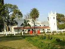
Aligarh has several popular landmarks. Most notable few of them are Aligarh fort, Another one is Khereshwar Temple which is the Birth Place of Swami Shri Haridas Ji, Teerthdham Mangalayatan Mandir and Dor fortress (1524), which is now in ruins, lies at the city's centre; its site is in the area now called Upper Fort (Balai Qila) and is occupied by an 18th-century mosque. The area Shah Jamal is very famous for a Sufi saint Syed Shah Jamal also known as Shamsul Arifeen, of whom the tomb is located at Shahjamal area and surrounded by a Graveyard and because of this famous personality the area got its name. The Sufi Saint is mentioned by Ibne Batuta in his book Travels of Ibne Batuta ; Volume 4. The saint is said to be of Sufi Chishtiya order.
The Annual Cultural Exhibition, popularly known as Numaish, is held at the exhibition ground in January and February.The Land Numaish Ground donated By Nawab Rehmat Ullah Khan Sherwani, The cultural shows takes place at 3 grand stages (Kohinoor, Krishnanjali, Muktakash). In all more than 150 stage events featuring artist from across the India takes place during a period of 28 days. In 2015, for the first time the major cultural programs of Numaish was managed by an Aligarh-based firm SAC Entertainment at Kohinoor stage.[13]
Historical places
- Shekha Jheel, Bird Sanctuary
- Maulana Azad Library(AMU campus) (Estd 1875)
- Aligarh Fort, known as Aligarh Quila
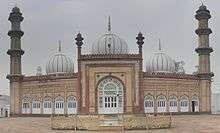
- Jama Masjid (Mosque) (Const 1727)
- Mangalayatan Temple,
Places of worship
Muslim places of worship:
- Nai abadi masjid
- Umar Farooq masjid Hamdard Nagar D
- Madina Masjid Hamdard Nagar B
- Nabi Karim Masjid Hamdard Nagar B
- Ek Minar Masjid Hamdard Nagar D
- Jama masjid
- Aïsha masjid
- Badi masjid
- Ahmad nagar masjid
- Noor masjid
- Barola masjid[14]
Khereshwar Temple which is the Birth Place of Swami Shri HARIDAS JI, "Sai Mandir" at Sarsol on G.T. Road. Many old Hindu temples in the city are near Achal Taal (opposite Dharma Samaj College). There are four key temples at four corners of the Achal Taal; all the four temples are Hindu Siddh Peeth. The Tika Ram mandir at centre point is also a renowned temple of the city. Khereshwar Dham is known for an ancient Lord Shiv temple and situated at Haridaspur, Aligarh (3 km from Aligarh). It is one of the famous temple of the city.
Another landmark is Sir Syed Masjid in Aligarh Muslim University's campus.
The city contains tombs of Muslim saints Shah Jamal at Shah Jamal Area Barchi Bahadur was the one of the Descendants of Shah Jamal.[15] Aligarh has a very renowned tomb, Baba Barchi Bahadur, at Kath Pula. Another old Jain temple with fresco painted ceilings is located behind Khirni Gate Police Chowky at Agra Road in the main City.
A famous Jainism Teerth Dhaam "Mangalayatan Teerth Dhaam" was built at Agra Road.
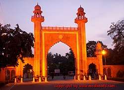
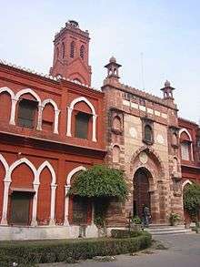
Aligarh Muslim University
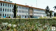
Aligarh Muslim University (AMU) is one of the oldest central universities. It was established by Sir Syed Ahmed Khan as Madrasatul Uloom Musalmanan-e-Hind, In 1875–78 which later became Mohammedan Anglo-Oriental College (MAO College). It was designed to train Muslims for government services in India and prepare them for advanced training in British universities. The Mohammedan Anglo-Oriental College became Aligarh Muslim University in 1920. It is famous for its Law, Medical and Engineering College. Madrak ka qila
Museums
Ibn Sina Academy of Medieval Medicine and Sciences maintains 'Museum on History of Medicine and Sciences' and 'Museum on Arts, Culture and Orientalism'. It was established by a family Hakim Syed Zillur Rahman and Syed Ziaur Rahman at the heart of the city and near a busy market of Dodhpur.[16][17]
Media
Aligarh currently has 5 + 1 FM Radio stations:
- 92.7 MHz Big FM
- 94.9 MHz Fever FM
- 104.6 MHz Tadka FM
- 94.1 MHz Current FM
- 101.3 MHz FM Rainbow
One Community FM Radio Station
- 90.8 MHz FM Alive
www.todayfastnews.com
apne adhikar janiye news paper
Film festival
International short film festival Filmsaaz is being held since 2008 by Aligarh Muslim University.
Culture, folk music and cinema
Various styles of music and art in folk songs of North India's Braj region include:
Transport
By rail
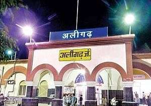
Aligarh Junction railway station is the primary station for Aligarh city and is a major stop on the Delhi-Kolkata route. It is a A-Class railway station. It is one of the oldest railway station of this route. It connects Aligarh to the states of West Bengal, Odisha, Bihar, Jharkhand, north-east and most of Uttar Pradesh, and important stations of cities such as New Delhi railway station, Mumbai Central, Kolkata, Bhopal Junction railway station, Indore, Jammu, Gwalior, Lucknow, Jhansi, Puri, Kanpur Central railway station, Etawah Junction railway station, Tundla Junction railway station, Phaphund railway station, Agra Cantonment railway station and Varanasi. Aligarh railway station handles over 136 trains daily (in both directions) and serves around 204,000 passengers everyday. Aligarh has one Branch Railway Line to Bareily.
Aligarh City has following railway stations:
- Aligarh Junction: a A-Class Railway Station
- Somna (Gabhana) railway station
- Mahrawal railway station
- Kalua railway station
- Daudkhan railway station
- Mandrak railway station
- Harduaganj railway station(Satha, near Kasimpur Power House)
- Manjoorgarhi railway station (Chherat)
By road
Aligarh is 140 km from New Delhi. It is one of the Division of UPSRTC. Uttar Pradesh State Road Transport Corporation (UPSRTC) buses serve cities all over the state and cities in Uttarakhand, Rajasthan, Madhya Pradesh and Haryana.
Aligarh City has two UPSRTC bus stations:
- Aligarh Depot bus station.
- Masoodabad (Budh Vihar) Depot bus station
- ISBT Rasualabad Sarsaul under construction.
There are buses plying from Aligarh to Delhi at frequent intervals via
1) Khair, Tappal, Palval, faridabad, delhi. the route is under construction between Khair and Palval and should be strictly avoided for cars. No toll charges.
2) Khair, Tappal, Yamuna expressway, G Noida, Noida, Delhi, Gurgaon. - Best and recommended Route for Delhi, Noida, Gurgaon. Toll Charges are 120 rs between aligarh and delhi.
3) Old GT Road, Bulandshahr, Ghaziabad, Delhi. NH 91, it is a four lane highway (Toll road). Toll charges 190 Rs.
Following Highways are connected to Aligarh.
- National Highway 91- It connects Kolkata to National capital New Delhi. Ghaziabad-Bulandshahr-Aligarh section is 4 Lane Highway.
- National Highway 93- It connects Moradabad to Taj Nagri Agra via Aligarh. Aligarh-Agra section is constructed as Brijbhoomi Expressway.
- Yamuna Expressway- It is 6 Lane Expressway Noida-Agra crossing at Tappal in Khair Tehsil from where Khair City is 30 km.
Aligarh City has Mahanagar Bus Service (City Bus Service) which provides local transport to Aligarh.
- Route-1 J N Medical-Uperkot
- Route-2 Gandhi Park-Sarsaul
- Route-3 Ghantarbagh-Quarsi
- Route-4 Gandhi Park-Boner
- Route-5 Etah Chungi-Collectrate
By air
The nearest international airport from Aligarh is Indira Gandhi International Airport, New Delhi. It is 140 km from Aligarh.
Aligarh Airport is in under construction, it is in Dhanipur on NH 91. Dhanipur Air Strip is used as Flying Club. The Government of Uttar Pradesh signed a MoU with the Airports Authority of India (AAI) in February 2014 for the development of the airport.The land acquisition for airport will be initiated soon and after its development flight will start under regional connectivity scheme.
Inter city transport
The government has proposed to operate city buses in Aligarh with following routes:-
- Aligarh Fort-Law Faculty-Firdaus Nagar-Shamshad-Collectorate-University Circle-Lal Diggi Lake-Amir Nishan-Marris Road Crossing-Kela Nagar Crossing-Chungi/Ramghat Road-Quarsi Crossing-Indrapuri/Great Mall-Mahaveer Nagar-DPS Civil Lines-St. Fidelis-Heritage-UPSIDC Harduaganj
- Bannadevi Crossing-Methodist Church-Exhibition Ground-RMPS Park-Ghantaghar-Centre Point-Melrose-Marris Road Crossing-Kela Nagar Crossing-
- Railway Station-Ghantaghar Circle-Tibiyya College-Lal Diggi Lake-Amir Nishan-Marris Road Crossing-Kela Nagar Crossing-Chungi/Ramghat-Quarsi Crossing-Jeevangarh-Dhorra-Jamalpur-Ayesha Tarin School-
Notable People
Educationalists
- Sir Syed Ahmad Khan founder of Aligarh Muslim University
- Sir Ziauddin Ahmed, Mathematician, M.L.A. (Central), Longest term Vice-Chancellor and pillar of Aligarh Muslim University Movement. He established several institution including J.N. Medical College.
Writers, poets and publishers
- Gopaldas Neeraj, poet, recipient of Padma Bhushan
- Jainendra Kumar, famous Hindi writer
- Akhlaq Mohammed Khan, pen name Shaharyar, Urdu poet, Bollywood lyricist and served as Professor at Aligarh Muslim University
- Maitreyi Pushpa, Notable Hindi fiction writer
- Saghar Nizami, Urdu Poet
- Qurratulain Hyder, a Padma Bhushan, Urdu novelist, writer and journalist
- Prem Kishore Patakha, Hindi Humorous Poet
- Munshi Newal Kishore famous book publisher
- A.R. Akela, Dalit author and publisher, owner of "Anand Sahitya Sadan"
- Syed Amin Ashraf, eminent Urdu poet and professor of English at AMU
- Rameshraj Tewarikar,Hindi Tewari poet, Editor:′ Tewari-Paksha(Tri-monthly)
Historians
- Mohammad Habib (1895–1971), noted Indian historian and served as Professor Emeritus at Aligarh Muslim University
- Irfan Habib, eminent Indian historian and Professor Emeritus at Aligarh Muslim University
Film actors
- Bharat Bhushan, Bollywood actor, scriptwriter and producer
- Chandrachur Singh, Bollywood actor
- Hasan Zaidi, Indian television actor
- Aadesh Chaudhary, Indian television actor
- Nitin Chauhaan, Indian television actor
- Ravindra Jain, Bollywood music director
- Vierendrra Lalit, Bollywood, Film Director-Cinematographer.
- Basharat Peer, Indian journalist and scriptwriter, written script for feature film Haider(2014)
- Zarina
Sports persons
- Annu Raj Singh, international shooter
- Zafar Iqbal, Former hockey captain of India
- Piyush Chawla, Indian cricketer
- Rinku Singh, Cricketer
Politicians
- Sandeep singh, MLA Atrauli, grandson of Sh. Kalyan Singh
- Thakur Dalveer Singh, MLA from Baruli vidhansabha constituency
- Sanjeev Raja, Current MLA
- Satish Kumar Gautam, current MP from, Aligarh (Lok Sabha constituency)
- Sheela Gautam, Ex MP & owner of Sleepwell
- Jamal Khwaja, Ex MP
- Bijendra Singh, Ex MP
- Thakur Jaiveer Singh, Ex MLA (Now MLC)
- Chaudhary Sunil Singh, Ex MLC
Medical professionals
- Hakim Syed Zillur Rahman, Unani physician and author
- Syed Ziaur Rahman, Medical pharmacologist, physician and author
- Khwaja Abdul Hamied, Pharmacist, founder of Cipla(a pharmaceutical company)
- Ashok Seth, an Indian interventional cardiologist
Social activists
- Jai Kishan Das, close associate of Sir Syed Ahmad Khan
- Rajiv Dixit, Indian social activist.
References
- ↑ "Aligarh City Population Census 2011 | Uttar Pradesh". Census2011.co.in. Retrieved 2015-11-06.
- ↑ "Top cities of India by population, Census 2011". Census2011.co.in. Retrieved 18 April 2014.
- 1 2 3 "Histor11". Aligarhdirectory.com. Archived from the original on 2004-10-11. Retrieved 2015-07-29.
- ↑ The Adventures of Ibn Battuta, by Ross E. Dunn, p. 215
- ↑ Edwin T. Atkinson (1875). Descriptive and Historical Account of the Aligarh District. p. 348. Retrieved 13 October 2011.
- ↑ "Falling Rain Genomics, Inc – Aligarh". Fallingrain.com. Retrieved 13 October 2011.
- ↑ "Aligarh Climatological Table Period: 1971–2000". India Meteorological Department. Retrieved April 15, 2015.
- ↑ "Ever recorded Maximum and minimum temperatures up to 2010" (PDF). India Meteorological Department. Archived from the original (PDF) on 21 May 2013. Retrieved April 15, 2015.
- 1 2 "Aligarh City Census 2011 data". Census2011.
- ↑ "India9.com". India9.com. 7 June 2005. Retrieved 13 October 2011.
- ↑ "Britannica". Britannica. Retrieved 13 October 2011.
- ↑ Pawan JainPawan Jain (3 June 2003). "Times of India". Timesofindia.indiatimes.com. Retrieved 13 October 2011.
- ↑ "Dainik Jagran". Epaper.jagran.com. 29 January 2015. Archived from the original on 21 May 2015. Retrieved 29 July 2015.
- ↑ "aligarh new masjid - Google Search". www.google.co.in. Retrieved 2018-10-12.
- ↑ Hoiberg, Dale; Ramchandani, Indu (2000). Students' Britannica India. New Delhi: Encyclopædia Britannica (India). ISBN 0852297602. OCLC 45086947.
- ↑ "World's 10 weirdest medical museums". Bryan Pirolli for CNN, Travel (May 24, 2013).
- ↑ "Ibn Sina Academy". Eram Agha for CNN-News18, (November 5, 2017).
Further reading
- Aligarh in My Days (Interviews of former Vice-Chancellors of Aligarh Muslim University), Ed. Syed Ziaur Rahman, Non-Resident Students' Centre, Aligarh Muslim University, Aligarh, 1997.
- Atkinson, Edward (2010) [1875]. Descriptive And Historical Account of the Aligarh District. Nabu Press. ISBN 1-147-42719-4.
| Authority control |
|---|