Gauley River National Recreation Area
| Gauley River National Recreation Area | |
| National Recreation Area | |
 | |
| Country | United States |
|---|---|
| State | West Virginia |
| Counties | Nicholas, Fayette |
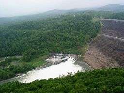
| Location | Summersville Dam outlet |
| - elevation | 1,375 ft (419.1 m) [1] |
| - coordinates | 38°13′12″N 80°53′24″W / 38.22000°N 80.89000°WCoordinates: 38°13′12″N 80°53′24″W / 38.22000°N 80.89000°W |
| Lowest point | Gauley River |
| Area | 11,507 acres (4,657 ha) |
| Established | 1988-10-26 |
| Management | New River Gorge National River |
| Owner | National Park Service |
| Visitation | 128,796 |
| IUCN category | V[2] |
| Nearest city | Summersville, West Virginia |
 Location of Gauley River National Recreation Area in West Virginia | |
| Website: Gauley River NRA | |
The Gauley River National Recreation Area, located near Summersville, West Virginia, protects a 25-mile (40 km) portion of the Gauley River and a 5.5-mile (8.9 km) segment of the Meadow River in southern West Virginia. Little of the park is accessible via roads; one must travel via the river. At the upstream end of the park is the Summersville Dam, the only area of the park accessible by vehicle.
Rapids
Within the park are a number of Class V rapids. They have been given names such as:
- Insignificant
- Pillow Rock
- Lost Paddle
- Iron Ring
- Sweet's Falls
References
- ↑ "Summersville Dam outlet". Elevation Query. U.S. Geological Survey. Retrieved 2009-01-31.
- ↑ "Gauley River National Recreation Area". Protected Planet. IUCN. Retrieved 30 April 2018.
External links
This article is issued from
Wikipedia.
The text is licensed under Creative Commons - Attribution - Sharealike.
Additional terms may apply for the media files.