Callander
Callander
| |
|---|---|
 | |
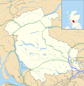 Callander Callander shown within the Stirling council area | |
| Population |
2,754 [1] (2001 census) est. 3,130[2] (2006) |
| OS grid reference | NN628079 |
| Council area | |
| Country | Scotland |
| Sovereign state | United Kingdom |
| Post town | CALLANDER |
| Postcode district | FK17 |
| Dialling code | 01877 33.... |
| Police | Scottish |
| Fire | Scottish |
| Ambulance | Scottish |
| EU Parliament | Scotland |
| UK Parliament | |
| Scottish Parliament | |
Callander (/ˈkæləndər/; Scottish Gaelic: Calasraid) is a small town in the council area of Stirling, Scotland, situated on the River Teith. The town is located in the historic county of Perthshire and is a popular tourist stop to and from the Highlands.
The town serves as the eastern gateway to the Loch Lomond and the Trossachs National Park, the first National Park in Scotland, and is often referred to as the "Gateway to the Highlands".[3]
Dominating the town to the north are the Callander Crags, a visible part of the Highland Boundary Fault, rising to 343 metres (1,125 ft) at the cairn.[4] Ben Ledi (879 metres, 2,884 ft) lies north-west of Callander. Popular local walks include Bracklinn Falls, The Meadows, Callander Crags and the Wood Walks.[5][5] The Rob Roy Way passes through Callander. The town sits on the Trossachs Bird of Prey Trail.[6] The River Teith is formed from the confluence of two smaller rivers, the Garbh Uisge (River Leny) and Eas Gobhain about 1⁄3 mile (500 m) west of the bridge at Callander.
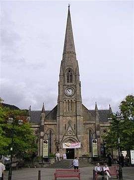
A 19th century Gothic church stands in the town square, named after Saint Kessog, an Irish missionary who is said to have preached in the area in the sixth-century. The church closed in 1985 and between 1990 and 2006 the building was home to a visitor centre and audio-visual attraction telling the story of local outlaw, Rob Roy MacGregor. The building is now the head office of The Clanranald Trust for Scotland.
Founded in 1892, McLaren High School educates pupils aged 11 to 18 from a wide catchment area extending as far as Killin, Tyndrum and Inversnaid.
Callander achieved prominence during the 1960s as the fictional setting "Tannochbrae" in the BBC television series Dr. Finlay's Casebook.[7]
Toponym
Callander is supposedly derived from the Scottish Gaelic name for the town, Calasraid: cala, signifying harbour or ferry; and sràid, the street or way to the ferry. This may refer to the landing place of a ferry that crossed the River Teith or literally “harbour street”. Alternatively, records from the 15th century onwards show forms such as, Kalendrech, Calendrate and Calindrade, which possibly indicate an earlier name for the estate. Other sources suggest that the name was transferred from the Barony of Callendar in Falkirk around the 16th century and it is probable that the current form was influenced by that spelling.[8]
History
A neolithic settlement situated south of the river was excavated in 2001 finding evidence of a timber building 25 metres (80 ft) in length along with neolithic pottery.[9] The Auchenlaich Cairn, a neolithic chambered cairn which at 322 metres (1,056 ft) in length is the longest in Britain, is situated near Keltie Bridge just east of Callander.[10] The remains of an ancient hillfort can be seen at Dunmore overlooking Loch Venachar, near Kilmahog. This fort was likely a large defended structure visible from some distance and excavations have revealed a well and signs of vitrified stonework.[11][12] Nearby, the remains of Roman ramparts constructed during the campaigns of Agricola in the first century AD are visible at Bochastle Farm.[13][12]
Saint Kessog, a disciple of Columba of Iona, preached and taught in this area in the early sixth century. A small mound by the River Teith is named in pseudo-Gaelic as "Tom na Chessaig", meaning "the Hill of Kessog". This man-made mound is circular with a level top approximately 10 metres (30 ft) in diameter. It is reputed to have been constructed as a memorial to the Saint or even to be the remains of Callander's original church (situated close to the old graveyard). The structure has actually been identified as a medieval motte, although no excavation has confirmed this. Historians record that an annual market called "Feill ma Chessaig" (festival of Kessog) was held here until the early 19th century.[14][15]
A medieval castle or tower house, Callander Castle, once stood south of the river, which is said to have been "a square tower of considerable height". This belonged to the Livingstones of Callendar House near Falkirk. The only remains of the castle are some masonry and a possible datestone inscribed 1596, which is now incorporated within the old St Kessog's Manse on the same site.[16]
In 1645, during the campaigns of Montrose, a battle was fought at Callander between the Campbells of Argyll and the Atholl men. The Campbells were harassing the McGregors and the McNabs for their allegiance to Montrose. While besieging Castle Ample, the news came of the advance of 700 Atholl men under Inchbrakie. A retreat was made southwards, but, as the Campbells were crossing a ford to the east of the village of Callander, they were overtaken and compelled to give battle. Inchbrakie, advancing part of his force to attack the defenders, quietly marched another detachment towards a ford higher up near the present bridge. A crossing was soon effected, and the Campbells, being unexpectedly attacked on the rear, broke and fled, leaving eighty of their men dead on the field.
The area around Callander was cleared for sheep before 1800 as part of the early phases of the Highland Clearances.[17]
As late as 1845 Scottish Gaelic was still spoken in Callander with two schools still teaching it.[18]
Callander was served by rail from 1 July 1858 as the terminus of a branch line from Dunblane.[19] A second Callander railway station was opened about 1⁄2 mile (800 m) to the west, behind the Dreadnought Hotel, on 1 June 1870 when the railway was extended to Killin en route to Oban, and closed on 5 November 1965. Sections of this former Callander and Oban Railway line, between Callander and Strathyre and between Balquhidder and Killin Junction, are now part of the National Cycle Network (route 7)[20] and the Rob Roy Way.[21] Track from the dismantled Callander and Oban Railway was used in the construction of the transit system for the 1968 Summer Olympics in Mexico City.[19]
Notable Residents
- Very Rev Andrew Nisbet Bogle DD (1868-1957) Moderator of the General Assembly of the Church of Scotland in 1930.
- Helen Duncan, from Callander, was the second to last person to be tried and imprisoned for the crime of Witchcraft in the UK, during World War Two.[22]
Annual events
- Callander X 10k (29 April 2012)[23]
- Trossachs Beer Festival (24 August - 3 September 2012)[24]
- Callander Jazz & Blues Festival (28–30 September 2012)[25]
Postcard gallery
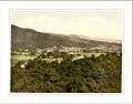 General view Callander
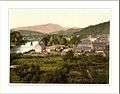 Callander Bridge
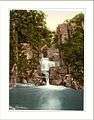
References
- ↑ "Comparative Population Profile: Callander Locality". Scotland's Census Results Online. 29 April 2001. Archived from the original on 19 May 2011. Retrieved 1 September 2008.
- ↑ "Archived copy". Archived from the original on 16 September 2009. Retrieved 2 September 2008.
- ↑ Gazetteer Link
- ↑ Ordnance Survey - Callander Crags
- 1 2 Callander and Local Area walks Archived 27 June 2007 at the Wayback Machine.
- ↑ "Trossachs Bird of Prey Trail". Archived from the original on 2013-10-04. Retrieved 2013-10-01.
- ↑ "BBC Alba to re-run Dr Finlay's Casebook to mark 50th anniversary". BBC News. 14 August 2012. Retrieved 11 October 2013.
- ↑ McNiven, Peter E. (2011). Gaelic place-names and the social history of Gaelic speakers in Medieval Menteith (PDF) (PhD). University of Glasgow.
- ↑ Barclay, Gordon; Brophy, Kenneth; MacGregor, Gavin (2002). "A Neolithic building at Claish Farm, near Callander, Stirling Council, Scotland, UK". Antiquity. Antiquity Publications. 76 (291): 23–24. Retrieved 26 April 2018.
- ↑ Batey, Colleen, ed. (1991). Discovery and Excavation in Scotland: an annual survey of Scottish archaeological discoveries, excavation and fieldwork (PDF). Council for Scottish Archaeology. p. 9. ISBN 090135211X. ISSN 0419-411X.
- ↑ "Dunmore". CANMORE. Royal Commission on the Ancient and Historical Monuments of Scotland. Retrieved 26 April 2018.
- 1 2 "Dunmore Hillfort and Bochastle Roman Fort". Retrieved 26 April 2018.
- ↑ "A History of Callander The Trossachs, Scotland". Archived from the original on 26 September 2013. Retrieved 1 October 2013.
- ↑ "Tom Na Chisaig - Canmore". Retrieved 11 October 2017.
- ↑ "A History of Callander The Trossachs, Scotland". Archived from the original on 26 September 2013. Retrieved 11 October 2013.
- ↑ "Callander Castle". CANMORE. Royal Commission on the Ancient and Historical Monuments of Scotland. Retrieved 26 April 2018.
- ↑ Campbell, Alexander (1804). The Grampians desolate: a poem. Edinburgh, J. Moir. pp. 210–211. Retrieved 25 November 2017.
- ↑ Newton, Michael.(2010). Bho Chluaidh Gu Calasraid - from the Clyde to Callander: Gaelic Songs, Poetry, Tales and Traditions of the Lennox and Menteith in Gaelic with English Translations, p. 285. The Grimsay Press ISBN 1845300688.
- 1 2 Thomas, John (1990). The Callander & Oban railway. The history of the railways of the Scottish Highlands. 4 (2 ed.). David St John Thomas. ISBN 9780946537464.
- ↑ National Cycle Network
- ↑ Rob Roy Way
- ↑ "Britain's 'last witch': Campaign to pardon Helen Duncan". BBC News. Retrieved 11 October 2013.
- ↑ Callander X 10k
- ↑ Trossachs Beer Festival Archived 5 November 2010 at the Wayback Machine.
- ↑ Callander Jazz & Blues Festival
External links
| Wikimedia Commons has media related to Callander. |