South Alloa
South Alloa
| |
|---|---|
.jpg) Kersie Terrace, South Alloa | |
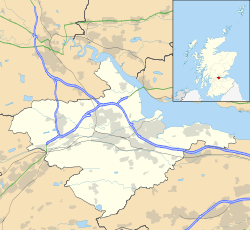 South Alloa South Alloa shown within the Falkirk council area | |
| Population | 112 [1] (2007 est.) |
| OS grid reference | NS875914 |
| • Edinburgh | 26.1 mi (42.0 km) SE |
| • London | 352 mi (566 km) SSE |
| Civil parish | |
| Council area | |
| Lieutenancy area | |
| Country | Scotland |
| Sovereign state | United Kingdom |
| Post town | STIRLING |
| Postcode district | FK7 |
| Dialling code | 01324 83 |
| Police | Scottish |
| Fire | Scottish |
| Ambulance | Scottish |
| EU Parliament | Scotland |
| UK Parliament | |
| Scottish Parliament | |
| Website | falkirk.gov.uk |
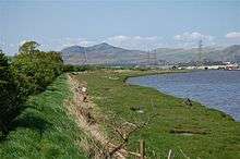
South Alloa is a small village which lies in the far north of the Falkirk council area of Scotland. The village is on the south bank of the River Forth where the river empties and widens to form the Firth of Forth. Directly to the north across the Forth is the town of Alloa, located 0.8 miles (1.3 km) away. Upstream and 5 miles (8.0 km) west-northwest is the city of Stirling and 7.3 miles (11.7 km) south is Falkirk, the principal town of the Falkirk council area. It lies just inside the council boundary line between Falkirk and Stirling councils.
The village lies off the A905 road between Dunmore and Throsk. The village is at a former ferry crossing point across the River Forth to Alloa. According to a 2007 estimate the village has 112 residents.[1]
See also
References
- 1 2 South Alloa - Conceptual Strategy www.falkirk.gov.uk. Retrieved 2012-03-14.
External links
| Wikimedia Commons has media related to South Alloa. |