Silchar
| Silchar | |
|---|---|
| Town | |
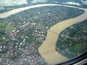 Aerial view of the Barak river, Silchar | |
| Nickname(s): The Island of Peace and The City of Love | |
 Silchar Location in Assam, India  Silchar Silchar (India) | |
| Coordinates: 24°49′N 92°48′E / 24.82°N 92.8°ECoordinates: 24°49′N 92°48′E / 24.82°N 92.8°E | |
| Country | India |
| State | Assam |
| District | Cachar |
| Region | Barak Valley |
| Government | |
| • Body | Silchar Municipal Corporation |
| • No. of Wards | 30 |
| Elevation | 22 m (72 ft) |
| Time zone | UTC+5:30 (IST) |
| PIN | 788001 to 788032 and 788118 |
| Telephone code | +91 (0) 3842 |
| ISO 3166 code | IN-AS |
| Vehicle registration | AS-11 |
| Official languages | Bengali |
| Website |
www |
Silchar (/ˈsɪlˌʧə/ or /ˈʃɪlˌʧə/) is the headquarters of Cachar district in the state of Assam in India. It is 343 kilometres (213 mi) south east of Guwahati.
Being politically stable in the otherwise disturbed Northeast earned it the bon mot of “Island of Peace” from India’s then Prime Minister Indira Gandhi.[1]
Etymology
During the British rule, ships were docked at the bank of the river Barak. Gradually, a market developed at the bank and became a major place of economic activity. The bank was covered with stones to help dock ships and vessels, and the market was developed at a place that was fully covered with stones. People started to refer to the place as Shiler Chor, meaning "a bank of stones". With the passage of time, Shiler Chor was simplified to Silchar, and ultimately the British officials started to use the name Silchar in their official documents referring to the surrounding area of the market. Thus Silchar became the official name of the place.[2]
History
Cachar district records
In the 1850s, British tea planters re-discovered the game polo in Manipur on the Burmese border with India. The first polo club in the world was formed at Silchar.[3][4]
The first competitive modern form of polo was played in Silchar, and the plaque for this feat still stands behind the District Library, Silchar.[3][4]
Language Movement in Barak Valley
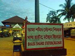
Silchar saw one of the uprisings in favour of the Bengali language. When the Assam government, under Chief Minister Bimala Prasad Chaliha, passed a circular to make Assamese mandatory, Bengalis of Barak Valley protested. On 19 May 1961, Assam police opened fire on unarmed protesters at Silchar railway station. Eleven martyrs had laid down their lives at Silchar Railway Station for the sake of Bengalis.
- Kanailal Niyogi
- Chandicharan Sutradhar
- Hitesh Biswas
- Satyendra Deb
- Kumud Ranjan Das
- Sunil Sarkar
- Tarani Debnath
- Sachindra Chandra Pal
- Birendra Sutradhar
- Sukamal Purakayastha
- Kamala Bhattacharya
After the popular revolt, the Assam government had to withdraw the circular and Bengali was ultimately given official status in the three districts of Barak Valley.[5][6] Section 5 of Assam Act XVIII, 1961, safeguards the use of Bengali in the Cachar district. It says, “Without prejudice to the provisions contained in Section 3, the Bengali language shall be used for administrative and other official purposes up to and including district level.”[7]
Industries
- ONGC has its base located at Srikona, near Silchar, which is known as Cachar Forward Base with ongoing operations in Tripura, Mizoram and Barak Valley.[8]
- Cachar Paper Mill (CPM) is the only major industrial undertaking in south Assam and the adjoining states of Mizoram, Meghalaya and Tripura. Despite lack of infrastructural facilities in a remote location, CPM has a continuous record of steady improvement. During the year 2006-07, the mill recorded the highest annual production of 1,03,155 MT registering over 103% capacity utilization, which was 100% during the previous year.[9]
Geography
Silchar is located in the southern part of Assam.[10][11]
The area of Silchar metro is 257.5 km2. It has an average elevation of 25 meters (82 feet).[12]
Demographics
As of 2011 India census, Silchar had a population of 2,28,324.[13] The sex ratio of Silchar was 988 females per 1000 males, which is above the national ratio of 940 females per 1000 males. Silchar metropolitan region has an average literacy rate of 90.26%,higher than the national average of 84% (2017), with male literacy of 92.90% and female literacy at 87.59%.[14] Hinduism is majority religion in Silchar city with 86.31% followers. Islam is second most popular religion in city of Silchar with approximately 12.17% following it. Jainism is followed by 0.79%, Christianity by 0.59%, Sikhism by 0.04% and Buddhism by 0.04% of the population in the Silchar city. Around 0.00% stated 'Other Religion', approximately 0.08% stated 'No Particular Religion'.[14]
Climate
Silchar has a borderline tropical monsoon climate (Köppen Am) slightly too hot in the “winter” or “cool” season to qualify as a humid subtropical climate (Cwa). During this “cool” season the weather is generally warm and dry with cool to mild mornings; however, the “wet” season begins early as the monsoon moves into the region during April, with the result that for seven months of the year Silchar has very hot and humid weather with heavy thunderstorms almost every afternoon until the middle of October, when there is usually a brief period of hot and relatively dry weather before the “cool” season sets in during November.
| Climate data for Silchar (1971–2000) | |||||||||||||
|---|---|---|---|---|---|---|---|---|---|---|---|---|---|
| Month | Jan | Feb | Mar | Apr | May | Jun | Jul | Aug | Sep | Oct | Nov | Dec | Year |
| Record high °C (°F) | 31.0 (87.8) |
35.0 (95) |
37.8 (100) |
39.4 (102.9) |
39.1 (102.4) |
37.9 (100.2) |
39.4 (102.9) |
39.0 (102.2) |
38.3 (100.9) |
36.7 (98.1) |
35.0 (95) |
31.7 (89.1) |
39.4 (102.9) |
| Average high °C (°F) | 24.5 (76.1) |
26.4 (79.5) |
29.6 (85.3) |
30.5 (86.9) |
31.0 (87.8) |
31.5 (88.7) |
31.4 (88.5) |
31.9 (89.4) |
31.5 (88.7) |
30.9 (87.6) |
29.1 (84.4) |
26.1 (79) |
29.6 (85.3) |
| Average low °C (°F) | 12.1 (53.8) |
14.1 (57.4) |
17.7 (63.9) |
21.0 (69.8) |
23.0 (73.4) |
24.6 (76.3) |
25.1 (77.2) |
25.2 (77.4) |
24.6 (76.3) |
22.9 (73.2) |
18.6 (65.5) |
13.9 (57) |
20.4 (68.7) |
| Record low °C (°F) | 3.3 (37.9) |
2.8 (37) |
8.3 (46.9) |
13.2 (55.8) |
15.6 (60.1) |
19.3 (66.7) |
19.0 (66.2) |
19.4 (66.9) |
16.8 (62.2) |
14.4 (57.9) |
10.6 (51.1) |
4.4 (39.9) |
5.0 (41) |
| Average precipitation mm (inches) | 12.1 (0.476) |
44.2 (1.74) |
229.3 (9.028) |
258.1 (10.161) |
460.7 (18.138) |
612.0 (24.094) |
503.2 (19.811) |
427.7 (16.839) |
366.5 (14.429) |
168.7 (6.642) |
33.3 (1.311) |
12.8 (0.504) |
3,128.6 (123.173) |
| Average rainy days | 1.0 | 3.9 | 8.5 | 12.6 | 16.2 | 21.5 | 22.5 | 19.3 | 15.5 | 7.7 | 2.4 | 0.6 | 131.6 |
| Source: India Meteorological Department (record high and low up to 2010)[15][16] | |||||||||||||
Education
University
Silchar is home to the main campus of Assam University, a central university, which imparts education in both the general as well as professional streams. The university, which came into existence in 1994, has 17 schools and 35 post-graduate departments under them. The university has 56 affiliated colleges under it.[17][18] The colleges in Silchar are mostly affiliated with the Assam university.
Technical institutions
Colleges
- Ramanuj Gupta Junior College
- Guru Charan College
- Cachar College
- Women's College
- Radhamadhab College
- Lalit jain commerce college[25]
Medical college
- Silchar Medical College and Hospital, established in 1968, serves the southern region of Assam. There is an Institute of Pharmacy attached to it.[26]
Law colleges
- A.K. ChandaLaw College[27] at Tarapur.
Airway transport
Silchar Airport (IXS) is located at Kumbhirgram, about 22 km from Silchar. Silchar has been selected as one of the towns for the construction of 51 low cost airports across the country recently.[28]
In December 1985, Air India operated the first all-woman crew flight in the world from Kolkata to Silchar which was commanded by Captain Saudamini Deshmukh on a Fokker F-27 Friendship aircraft.[29]
Politics
Silchar is part of the Silchar (Lok Sabha constituency). The current member of Parliament from Silchar is Sushmita Dev who is the youngest daughter of the veteran politician Santosh Mohan Dev of the Indian National Congress.[30]
People from Silchar
See also
References
- ↑ "APCC member for nomination of Gaurav Gogoi from Barak Valley". The Sentinel, Assam. 6 June 2012. Retrieved 4 July 2012.
- ↑ "Silchar (India) - Britannica Online Encyclopedia". Britannica.com. Retrieved 2012-08-17.
- 1 2 "The Sport". guardspoloclub. Retrieved 25 December 2016.
- 1 2 "Polo of Victorians". Polo of Victorians. avictorian.com. Retrieved 25 December 2016.
- ↑ "No alliance with BJP, says AGP chief". The Telegraph, Calcutta. 27 December 2003. Retrieved 3 March 2014.
- ↑ "Silchar rly station to be renamed soon". The Times of India. 9 Jun 2009. Retrieved 3 March 2014.
- ↑ "Compulsory use of Bengali Language in Cachar". Silchar News. 2013-07-24. Retrieved 2016-12-18.
- ↑ "ONGC :: ONGC Offices". Retrieved 8 June 2015.
- ↑ http://www.hindpaper.in/mills/cachar.htm
- ↑ "Location of Silchar". Wikimapia Foundation. Wikimapia. Retrieved 3 March 2014.
- ↑ "Silchar, India Page". Falling Rain Genomics, Inc. Falling Rain Genomics, Inc. Retrieved 3 March 2014.
- ↑ "Silchar, Cachar, Assam, India Map Lat Long Coordinates". www.latlong.net. Retrieved 2016-02-26.
- ↑ "Census of India". Govt. of India. Government of India. Retrieved 20 February 2014.
- 1 2 "Silchar City Population Census 2011 | Assam". www.census2011.co.in. Retrieved 2016-02-26.
- ↑ "Silchar Climatological Table Period: 1971–2000". India Meteorological Department. Retrieved 27 April 2015.
- ↑ "Ever recorded Maximum and minimum temperatures up to 2010" (PDF). India Meteorological Department. Archived from the original (PDF) on 21 May 2013. Retrieved 27 April 2015.
- ↑ "Assam University, Homepage". Assam University. Retrieved 20 February 2014.
- ↑ "Statistical Data Fact Sheet of AUS" (PDF). Assam University. Assam University. Retrieved 20 February 2014.
- ↑ "TSSOT". Retrieved 8 June 2015.
- ↑ http://silcharpolytechnic.in/
- ↑ http://www.assamtribune.com/scripts/detailsnew.asp?id=jan1015/state052
- ↑ http://cdac.in/index.aspx?id=pk_itn_spot919
- ↑ http://www.guwahati.nielit.gov.in/aboutsec.php
- ↑ Super User. "NIAIMT Silchar". Retrieved 8 June 2015.
- ↑ http://www.dheassam.gov.in/circulars-1/meeting%2057.pdf retrieved on 14 January 2015
- ↑ "Silchar Medical College, Home Page". Silchar Medical College. Silchar Medical College. Retrieved 20 February 2014.
- ↑ "A. K. Chanda Law College". Retrieved 8 June 2015.
- ↑ "51 new low-cost airports to be set up: PMO". Daily News & Analysis. 28 June 2013. Retrieved 3 March 2014.
- ↑ "Capt V Roopa: Flying high, and back". The Times of India. Retrieved 8 June 2015.
- ↑ "List of Parliamentary & Assembly Constituencies" (PDF). Assam. Election Commission of India. Retrieved 2008-10-05.
External links
| Wikimedia Commons has media related to Silchar. |

- Britannica article on Silchar
| Topics | |||||||||||
|---|---|---|---|---|---|---|---|---|---|---|---|
| History | |||||||||||
| Administration | |||||||||||
| Districts and divisions |
| ||||||||||
| Geography | |||||||||||
| Culture | |||||||||||
| Arts, literature, music and cinema |
| ||||||||||
| People | |||||||||||
| Notable surnames |
| ||||||||||
| Urban areas | |||||||||||
| |||||||||||
| Authority control |
|---|