Bradford-on-Avon
| Bradford-on-Avon | |
|---|---|
.JPG) The Town Bridge over the river Avon. The small domed building is the lockup, where the town's troublemakers were put for the night. | |
 Bradford-on-Avon Bradford-on-Avon shown within Wiltshire | |
| Population | 9,402 (in 2011)[1] |
| OS grid reference | ST826609 |
| Civil parish |
|
| Unitary authority | |
| Ceremonial county | |
| Region | |
| Country | England |
| Sovereign state | United Kingdom |
| Post town | BRADFORD-ON-AVON |
| Postcode district | BA15 |
| Dialling code | 01225 |
| Police | Wiltshire |
| Fire | Dorset and Wiltshire |
| Ambulance | South Western |
| EU Parliament | South West England |
| UK Parliament | |
| Website | Town Council |
Bradford-on-Avon (sometimes Bradford on Avon) is a town and civil parish in west Wiltshire, England, with a population of 9,402 at the 2011 census.[1] The town's canal, historic buildings, shops, pubs and restaurants make it popular with tourists.
The history of the town can be traced back to Roman origins. It has several buildings dating from the 17th century, when the town grew due to the thriving English woollen textile industry.
Geography
Physical
The town lies partly on the Avon Valley, and partly on the hill that marks the Vale's western edge, eight miles southeast of Bath, in the hilly countryside between the Mendip Hills, Salisbury Plain and the Cotswold Hills. The local area around Bath provides the Jurassic limestone (Bath Stone) from which the older buildings are constructed. The River Avon (the Bristol Avon) runs through the town. The town directly borders Trowbridge to the south east.
Human
The town includes the suburbs of Bearfield and Woolley; the parish includes the hamlets of Widbrook and Woolley Green.
The Western Wiltshire Green Belt forms the eastern extent of the Avon Green Belt, and it completely surrounds Bradford-on-Avon, helping to maintain the setting and preserve the character of the town, and minimising urban sprawl between Bath and other nearby settlements such as Trowbridge, Winsley, and Westwood.[2][3]
History
The earliest evidence of habitation is fragments of Roman settlements above the town. In particular, archaeological digs have revealed the remains of a large Roman villa with a well-preserved mosaic on the playing fields of St Laurence School. The centre of the town grew up around the ford across the river Avon, hence the origin of the town's name ("Broad-Ford").[4] This was supplemented in Norman times by the stone bridge that still stands today. The Norman side is upstream, and has pointed arches; the newer side has curved arches. The Town Bridge and Chapel is a grade I listed building. It was originally a packhorse bridge, but widened in the 17th century by rebuilding the western side.[5] On 2 July 1643 the town was the site of a skirmish in the English Civil War, when Royalists seized control of the bridge on their way to the Battle of Lansdowne.[6]
On the bridge stands a small building which was originally a chapel but was later used as a town lockup. The weather vane on top takes the form of a gudgeon,[4] (an early Christian symbol), hence the local saying "under the fish and over the water".
Widbrook Grange is a Georgian manor house on the edge of the town. It was built as a model farm on Earl Manvers' estate; it is now run as a hotel.
The river provided power for the wool mills that gave the town its wealth. The town has 17th-century buildings dating from the most successful period of the local textile industry. The best examples of weavers' cottages are on Newtown, Middle Rank and Tory Terraces. Daniel Defoe visited Bradford-on-Avon in the early 18th century[4] and commented: "They told me at Bradford that it was no extra-ordinary thing to have clothiers in that country worth, from ten thousand, to forty thousand pounds a man [equivalent to £1.3M to £5.3M in 2007], and many of the great families, who now pass for gentry in those counties, have been originally raised from, and built up by this truly noble manufacture."[7]
With improving mechanisation in textile manufacture during the Industrial Revolution, the wool weaving industry moved from cottages to purpose-built woollen mills adjacent to the river, where they used water and steam to power the looms. Around thirty such mills were built in Bradford-on-Avon alone, and these prospered further until the English woollen industry shifted its centre of power to Yorkshire in the late 19th century. The last local mill closed in 1905. Many have since stood empty and some became derelict.

A notable feature of Bradford-on-Avon is the large Grade II* listed tithe barn, known as the Saxon Tithe Barn, 180 feet long and 30 feet wide, which was constructed in the 14th century and is now part of Barton Farm Country Park.[8] The barn would have been used for collecting taxes, in the form of goods, to fund the church.
There are several notable buildings in and around the town centre. Many of the old textile factories have been converted into modern flats and apartments; however, few of the buildings are still used today in their original roles. One of the few is The Swan, a public house and hotel set in the centre of town; the building is 17th century and retains many original features, in particular the stone flag floors. Records show that there has been a public house on the same site since the 1500s.
In 1998 the Wiltshire Music Centre was opened in Bradford-on-Avon, on the grounds of St Laurence School. In 2000, the millennium sculpture nicknamed "Millie" was unveiled.
On 8 October 2003, Bradford-on-Avon was granted Fairtrade Town status.
Religious sites
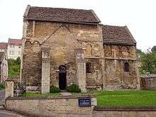
The Saxon church dedicated to Saint Lawrence may have been founded by Saint Aldhelm around 705, and could have been a temporary burial site for King Edward the Martyr. It was rediscovered by Canon William Frampton in 1856, having been used for secular purposes (apparently becoming a house, a school and part of a factory). In his research Canon Frampton, who had an interest in archaeology, found reference to the church in the writings of William of Malmesbury.
It is suggested that some of the building, containing the blind arcades at a higher level, may belong to a later period[9] while a leaflet available at the church, February 2012, seems to prefer the period 950–1050 for the whole building. The elaborate ornamentation of the exterior consists of pilaster-strips, a broad frieze of two plain string-courses between which is a blind arcade of round-headed arches whose short vertical pilasters have trapezoidal capitals and bases, while on the eastern gable and the corners adjacent there is a series of mouldings as vertical triple semicylinders.[10]
Inside the church, high in the wall above a small chancel arch, are the carved figures of two flying angels, the right-hand figure reportedly "intended to be clothed in transparent drapery ... the legs from the knee downward are depicted as showing through the transparent robe" which is referred to as a "quaint fancy".[11]
In addition to the Saxon church, the town has four Church of England churches, one Church of England chapel, two Baptist chapels, a United Church (Methodist and United Reformed Church), a free nonconformist church, a community church, a Quaker (Society of Friends) meeting house and a Roman Catholic church.
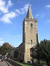
The original parish church has a dedication to the Holy Trinity, and is located near the town centre by the river. It is Norman in origin, and it is possible that the chancel was built over the remains of an older church. Several chapels were added on the north side, and the wall in between was later opened up and the chapels now form the north aisle. A squint, or hagioscope, near the altar is claimed to be England's longest. The tower and spire was built around 1480, replacing an older one, and the south wall was largely rebuilt in the 19th century.[12] The church has a ring of eight bells, with the tenor (heaviest bell) weighing 29 long cwt 2 qr 26 lb (3,330 lb or 1,510 kg) and is tuned to D♭.
The other Anglican church has dedication of Christ Church, and is entirely a Victorian construction.[13] The Catholic church, dedicated to St. Thomas More, occupies the building that used to be the town hall.[14]
There is also a Buddhist monastery in the town, under the auspices of the Aukana Trust; it comprises a monastic building each for men and for women, and a meditation hall. There are also workshops, gardens and a library, and the elegant buildings look down upon the town from a hill. The monastery practises the Theravadin tradition of Buddhism, and offers opportunities for both full-time residential and part-time practise and study.
Economy

Bradford-on-Avon has been the headquarters of Avon Rubber, a large manufacturer of rubber products for the automotive and other industries. Today, it is the headquarters of the Alex Moulton bicycle company. It has several other small scale manufacturing enterprises.
The town's main business is retail shopping, tourism and day to day servicing of a population largely made up of families, commuters and the retired.
The town has one mid-sized supermarket, Sainsbury's, situated on the Elms Cross Industrial estate, a two-minute walk from the Canal lock, and five convenience stores.[15] Local consumers founded Bradford-on-Avon Co-operative Society in 1861, which, in the 1960s, united with other consumer co-operatives in the district to merge with a national business. [16][17] A mini outdoor shopping centre of independent shops, Weavers Walk, which describes itself as an "ethical trading centre", is in the town centre.
The town is an increasingly popular location for films, television adaptations and more; it has played host to Wolf Hall, Creation (The life of Darwin), Robin of Sherwood and a film adaptation of Canterbury Tales.
More recently, in mid 2016, The White Princess (TV series) began filming in the area.[18]
Transport
Road
Bradford-on-Avon lies on the A363 Trowbridge to Bath road, which runs through the town from south to north, and crossed over by the B3109 linking Bradford-on-Avon with Melksham and Frome. All other road routes are minor, affording access to local settlements.
Rail
Bradford-on-Avon railway station lies on what is now the Bristol—Weymouth railway line. It opened in the mid-19th century and was built by the original Great Western Railway.
Waterways
Running parallel to the railway through the town is the Kennet and Avon Canal and Bradford Lock. The use of this canal declined as the railways grew but it was restored to full working order during the 1960s, 1970s and 1980s. The canal provides a link through to the Avon at Bath in the west, and the Thames at Reading in the east.
Governance
Bradford-on-Avon civil parish elects a town council with twelve members: six for the North ward and six for the South ward. After the elections held in May 2017, Bradford on Avon Town Council comprised ten councillors elected on the Ideal Bradford[19] party platform, and two Liberal Democrat councillors.[20]
The town council is providing an increasing range of services in the town, building on its historically mostly consultative and ceremonial role, and its chairman has the title of Mayor of Bradford. The most significant local government functions (including schools, roads, social services, emergency planning, leisure services, development control, and waste disposal) are carried out by Wiltshire Council, a unitary authority.
Since 2010, Bradford-on-Avon has been part of the Chippenham parliamentary constituency.
See also:
Education
The town has one secondary school, St Laurence School, a specialist Arts College.
Sport and leisure
Bradford-on-Avon has a Non-League football club, Bradford Town F.C., who play at the Sports and Social Club on Trowbridge Road. There is also Bradford-on-Avon Rowing Club, based in Pound Lane near to the Tithe Barn. The club caters for rowing and canoeing.
Wiltshire Music Centre is a purpose-built, 300-seat concert hall that attracts internationally renowned musicians. Situated within the grounds of the St Laurence School, it is renowned for its fine acoustics.
Notable people
- John Methuen and his son Sir Paul Methuen, successively Ambassadors to Portugal
- Peter Hammill, singer-songwriter
- Henry Shrapnel, inventor of the shrapnel shell
- Shadrack Byfield, War of 1812 infantryman and memoirist
- Miles Kington, journalist
- Alex Moulton, engineer and inventor
- Simon R. Green, science-fiction/fantasy author
- Rugby union players Will Carling, Phil de Glanville, Jon Sleightholme and Lewis Moody
- Hugh Scully, television presenter
- Jonathan Newth, actor
- Rob Newman, ex-footballer and current football manager
- Paul Emsley, artist
- Andy Pearce, ex-footballer
- Stephen Volk, TV scriptwriter, TV series Afterlife, Dark Corners
- Simon Tisdall, journalist
- Samuel Meredith, first British Chief Constable in 1839
- Pop groups Jesus Jones and Blackbud were both formed in the town
- Fitzroy Simpson, former professional footballer
- Ed McKeever, Olympic canoeing champion
- Emily Hilda Young, novelist
- Donald Maitland, senior diplomat
References
- 1 2 "Wiltshire Community History - Census". Wiltshire Council. Retrieved 16 February 2016.
- ↑ "Wiltshire Core Strategy - Adopted January 2015" (PDF). www.wiltshire.gov.uk.
- ↑ "Bath & North East Somerset Green Belt Review - Stage 1 Report April 2013 - Green Belt history and policy origins" (PDF). www.bathnes.gov.uk.
- 1 2 3 "Victoria County History - Wiltshire - Vol 7 pp4-51 - Parishes: Bradford-on-Avon". British History Online. University of London. Retrieved 16 February 2016.
- ↑ "The Town Bridge and Chapel". Images of England. Retrieved 2006-08-24.
- ↑ Barratt, John (2005). The civil war in the south west. Bernsley: Pen & Sword Military. p. 48. ISBN 1-84415-146-8.
- ↑ Defoe, Daniel. A Tour Through the Whole Island of Great Britain: Vol 1. p. 281.
- ↑ "Tithe Barn". Images of England. Retrieved 2006-08-24.
- ↑ H.M.Taylor & Joan Taylor, Anglo-Saxon Architecture, Cambridge University Press, 1980
- ↑ Taylor & Taylor, op. cit.
- ↑ Gordon Home & Edward Foord, "Bristol, Bath and Malkmesbury, with a Short Account of Bradford on Avon" in the series Cathedrals, abbeys and Famous Churches, J.M.Dent, London, 1925
- ↑ "Holy Trinity Church". Images of England. Retrieved 2006-08-24.
- ↑ "Christ Church". Images of England. Retrieved 2006-08-24.
- ↑ "Roman Catholic Church of St Thomas More". Images of England. Retrieved 2006-08-24.
- ↑ "Grocers and convenience stores". Yell.com Yellow Pages directory. Retrieved 2008-08-11.
- ↑ "Coop Online Share Book search: Bradford-on-Avon". Retrieved 2008-05-21.
- ↑ "Listing of co-operatives in the ACDA area". Avon Co-operative Development Agency. Archived from the original on 2 August 2008.
Its five shops in Bristol, Stroud, Glastonbury, Totnes and Bradford-on-Avon sell clothes for adults and children
- ↑ "Bradford on Avon is centre stage for filming of White Princess". Wiltshire Times. Newsquest. 3 September 2016. Retrieved 4 January 2016.
in the Tithe Barn, near Frome Road, and St Laurence's Church, in Church Street.
- ↑ "Ideal Bradford". Retrieved 20 January 2018.
- ↑ "Meet your Town Councillors". Bradford on Avon Town Council. Retrieved 20 January 2018.
External links
| Wikivoyage has a travel guide for Bradford on Avon. |
| Wikimedia Commons has media related to Bradford-on-Avon. |
| Wikisource has the text of the 1911 Encyclopædia Britannica article Bradford-on-Avon. |
- Bradford on Avon Town Council
- Bradford-on-Avon at Curlie (based on DMOZ)
- Historic Bradford-on-Avon photos at BBC Wiltshire
- Six English Towns: Bradford-on-Avon - A 35-minute BBC TV programme made in 1981 examining Bradford-on-Avon's Georgian buildings and architecture
- Day Out: Bradford-on-Avon - A 30-minute BBC TV programme made in 1978 of a day spent exploring Bradford-on-Avon
| Unitary authorities | |
|---|---|
| Major settlements | |
| Rivers | |
| Topics | |