Aomori (city)
| Aomori 青森市 | |||
|---|---|---|---|
| Core City | |||
 | |||
| |||
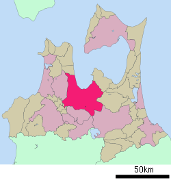 Location of Aomori in Aomori Prefecture] | |||
 Aomori | |||
| Coordinates: 40°49′20.4″N 140°43′50.6″E / 40.822333°N 140.730722°ECoordinates: 40°49′20.4″N 140°43′50.6″E / 40.822333°N 140.730722°E | |||
| Country | Japan | ||
| Region | Tōhoku | ||
| Prefecture | Aomori | ||
| Government | |||
| • Mayor | Akihiko Onodera | ||
| Area | |||
| • Total | 824.61 km2 (318.38 sq mi) | ||
| Elevation | 2 m (7 ft) | ||
| Population (April 1, 2017) | |||
| • Total | 287,800 | ||
| • Density | 350/km2 (900/sq mi) | ||
| Time zone | UTC+9 (Japan Standard Time) | ||
| City symbols | |||
| • Tree | Maries' fir | ||
| • Flower | Rosa rugosa | ||
| • Bird | Ural owl | ||
| • Insect | Firefly | ||
| Phone number | 017-734-1111 | ||
| Address | 1-22-5 Chūō, Aomori-shi, Aomori-ken 030-8555 | ||
| Website | Official website | ||


Aomori (青森市 Aomori-shi) is the capital city of Aomori Prefecture, in the Tōhoku region of Japan. As of 1 April 2017, the city had an estimated population of 287,800 in 136,209 households,[1] and a population density of 350 persons per km2. The city is one of Japan's 48 core cities. The total area of the city was 824.61 square kilometres (318.38 sq mi).
Geography
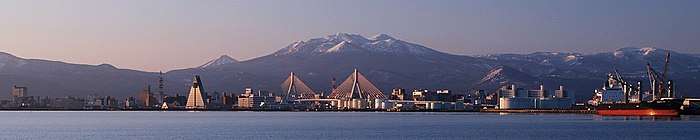
Aomori is located in central Aomori Prefecture, on a plain between the southern end of Aomori Bay, which it faces to the north and the Hakkōda Mountains to the south. Among other smaller rivers, the city has two large rivers flowing through it, the Komagome River and its tributary, the Arakawa River.
Neighbouring municipalities
- Aomori Prefecture
Climate
Like most of Tōhoku, Aomori has a humid temperate climate with hot summers, and cold, though not extreme, winters. The city has a humid continental climate (Köppen Dfa) using 0 degree isotherm, with monthly averages ranging from −1.2 °C (29.8 °F) in January to 23.3 °C (73.9 °F) in August.[2]
Aomori and its surrounding area are renowned for heavy snowfall, the heaviest among all Japanese cities, and, in fact, among the heaviest in the world. In February 1945 the city recorded a maximum snow cover of 209 centimetres (82 in), but the extreme low of −24.7 °C (−12 °F) was recorded 14 years earlier. In contrast, Sapporo's heaviest snowfall occurred in 1939, and that was only 164 centimetres (65 in), and more northerly Wakkanai has recorded similar maxima. The particularly heavy snow is caused by several winds that collide around the city and make the air rise and cool, resulting in quick, thick cloud formation followed by intense precipitation.
In summer, a cool wind called "Yamase" often blows from the east, which sometimes results in abnormally cool weather and poor harvests. Additionally, thick fogs from the Oyashio Current are often observed in mountainous areas in the summer. Due to this fog, flights to Aomori Airport are often cancelled.
| Climate data for Aomori, Aomori | |||||||||||||
|---|---|---|---|---|---|---|---|---|---|---|---|---|---|
| Month | Jan | Feb | Mar | Apr | May | Jun | Jul | Aug | Sep | Oct | Nov | Dec | Year |
| Record high °C (°F) | 13.5 (56.3) |
17.1 (62.8) |
20.1 (68.2) |
28.3 (82.9) |
31.3 (88.3) |
33.5 (92.3) |
35.4 (95.7) |
36.7 (98.1) |
36.1 (97) |
30.5 (86.9) |
23.8 (74.8) |
21.1 (70) |
36.7 (98.1) |
| Average high °C (°F) | 1.6 (34.9) |
2.3 (36.1) |
6.3 (43.3) |
13.5 (56.3) |
18.4 (65.1) |
21.7 (71.1) |
25.4 (77.7) |
27.7 (81.9) |
24.0 (75.2) |
18.0 (64.4) |
10.9 (51.6) |
4.6 (40.3) |
14.5 (58.1) |
| Daily mean °C (°F) | −1.2 (29.8) |
−0.7 (30.7) |
2.4 (36.3) |
8.3 (46.9) |
13.3 (55.9) |
17.2 (63) |
21.1 (70) |
23.3 (73.9) |
19.3 (66.7) |
13.1 (55.6) |
6.8 (44.2) |
1.5 (34.7) |
10.4 (50.7) |
| Average low °C (°F) | −3.9 (25) |
−3.7 (25.3) |
−1.3 (29.7) |
3.7 (38.7) |
8.9 (48) |
13.5 (56.3) |
18.0 (64.4) |
19.8 (67.6) |
15.1 (59.2) |
8.6 (47.5) |
3.0 (37.4) |
−1.4 (29.5) |
6.7 (44.1) |
| Record low °C (°F) | −23.5 (−10.3) |
−24.7 (−12.5) |
−18.4 (−1.1) |
−12.2 (10) |
−1.4 (29.5) |
4.0 (39.2) |
6.5 (43.7) |
8.9 (48) |
3.0 (37.4) |
−2.4 (27.7) |
−12.1 (10.2) |
−20.6 (−5.1) |
−24.7 (−12.5) |
| Average precipitation mm (inches) | 144.9 (5.705) |
111.0 (4.37) |
69.9 (2.752) |
63.4 (2.496) |
80.6 (3.173) |
75.6 (2.976) |
117.0 (4.606) |
122.7 (4.831) |
122.7 (4.831) |
103.9 (4.091) |
137.7 (5.421) |
150.8 (5.937) |
1,300.1 (51.185) |
| Average snowfall cm (inches) | 225 (88.6) |
176 (69.3) |
76 (29.9) |
6 (2.4) |
0 (0) |
0 (0) |
0 (0) |
0 (0) |
0 (0) |
0 (0) |
32 (12.6) |
153 (60.2) |
669 (263.4) |
| Average precipitation days (≥ 0.5 mm) | 24.3 | 20.7 | 16.7 | 11.2 | 11.5 | 9.4 | 10.3 | 10.7 | 11.8 | 14.5 | 18.8 | 23.3 | 183.2 |
| Average snowy days | 28.5 | 24.2 | 19.5 | 3.3 | 0 | 0 | 0 | 0 | 0 | 0.4 | 9.4 | 23.1 | 108.4 |
| Average relative humidity (%) | 78 | 76 | 69 | 66 | 70 | 78 | 80 | 79 | 76 | 73 | 72 | 77 | 75 |
| Mean monthly sunshine hours | 51.3 | 69.8 | 130.5 | 182.3 | 201.1 | 179.6 | 159.5 | 180.3 | 158.4 | 149.7 | 87.6 | 52.8 | 1,602.7 |
| Source #1: 気象庁[3] | |||||||||||||
| Source #2: Kishōchō[4] | |||||||||||||
Demographics
Per Japanese census data,[5] the population of Aomori has remained relatively steady over the past 40 years.
| Census Year | Population |
|---|---|
| 1970 | 261,743 |
| 1980 | 309,768 |
| 1990 | 308,782 |
| 2000 | 318,732 |
| 2010 | 299,520 |
History

Aomori literally means blue forest, although it could possibly be translated as "green forest". The name is generally considered to refer to a small forest on a hill which existed near the town. This forest was often used by fishermen as a landmark. A different theory suggests the name might have been derived from the Ainu language.
The area has been settled extensively since prehistoric times, and numerous Jōmon period sites have been found by archaeologists, the most famous being the Sannai-Maruyama Ruins located just southwest of the city center dating to 5500-4000 BC, and the Komakino Site slightly farther south dating to around 4000 BC. The large scale of these settlements revolutionized theories on Jōmon period civilization. During the Heian period, the area was part of the holdings of the Northern Fujiwara clan, but remained inhabited by the Emishi people well into the historic period. After the fall of the Northern Fujiwara in the Kamakura period, the territory was part of the domain assigned to the Nambu clan, and into the Sengoku period, it came under the control of the rival Tsugaru clan, whose main castle was located in Namioka. After the start of the Edo period, Aomori was a minor port settlement for Hirosaki Domain called Utō (善知鳥村 Utō-mura). The town was rebuilt in 1626 under orders of the daimyō, Tsugaru Nobuhira and renamed "Aomori", but this name did not come into common use until after 1783.
After the Meiji Restoration, the feudal domains were abolished and replaced with prefectures, of which a total of six were initially created in the territory of modern Aomori Prefecture. These were merged into the short-lived Hirosaki Prefecture in July 1871. However, due to the historic enmity between the former Tsugaru territories in the west and the former Nambu territories in the east, the prefectural capital relocated from Hirosaki to the more centrally-located Aomori immediately after the merger and the prefecture was renamed Aomori Prefecture on September 23, 1871. However, the municipality of Aomori was not given town status within Higashitsugaru District until April 1, 1889, and was not designated a city until April 1, 1898.
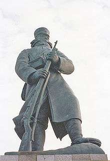
The Hokkaidō Colonization Office began operations of a ferry service from Aomori to Hakodate in Hokkaido from 1872. In September 1891, Aomori was connected with Tokyo by rail with the opening of the Tōhoku Main Line. The Ōu Main Line running along the Sea of Japan coast opened in December 1894. The development of modern Aomori was primarily due to its prefectural capital status and the singular importance as the terminus of these rail lines and the Seikan ferry, which officially opened in 1908. The 8th Division of the Imperial Japanese Army were stationed in Aomori from 1896. In the winter of 1902, 199 of 210 soldiers on a military cold-weather readiness exercise perished while attempting to cross the Hakkōda Mountains from Aomori to Towada in what was later called the Hakkōda Mountains incident.
Much of the town burned down in a large fire on May 3, 1910. The port facilities were expanded in 1924, and the city received its first bus services in 1926. Japan Air Transport began scheduled air services from 1937.
Towards the final stages of World War II, on the night of July 28–29, 1945, Aomori was subject to an air raid as part of the strategic bombing campaign waged by the United States of America against military and civilian targets and population centers during the Japan home islands campaign. The July 28–29 bombing claimed 1,767 lives and destroyed 88% of the city.
In the post war period, Aomori rebuilt as the local political and commercial center. The Tsugaru Line railway opened in 1951, and Aomori Airport in 1964. The city was connected to Tokyo by highway in 1979 with the opening of the Tōhoku Expressway. Aomori's landmark pyramidal Aomori Prefecture Tourist Center opened in 1986. On October 1, 2002, Aomori was proclaimed a core city with increased local autonomy.
On April 1, 2005, Aomori absorbed the town of Namioka was to create the new and expanded city of Aomori; but lost a portion of Namioka to the town of Fujisaki (from Minamitsugaru District) on September 1, 2007.
Government
Aomori has a mayor-council form of government with a directly elected mayor and a unicameral city legislature of 35 members. The city also contributes 10 members of the 48 member Aomori Prefectural Assembly. In terms of national politics, most of the city falls within the Aomori 1st district, a single-member constituency of the House of Representatives in the national Diet of Japan, which also includes the city of Goshogawara and Higashitsugaru District and Kitatsugaru District; however, the former town of Namioka is within the Aomori 4th district.
Economy
Aomori serves as the regional commercial center for central Aomori Prefecture. Agriculture and commercial fishing form only 4% of the city economy, with manufacturing forming 16.2% and the service sector forming 78.2%.
Transportation
Airport
- Aomori Airport - (established in 1964 with international flights from 1995) is about a 35-minute drive from the city center, with a bus service available. There are daily flights to Tokyo, Osaka, Nagoya and Sapporo. There are also flights to Seoul, South Korea and Tianjin, China.
Railways
Aomori Station has been the main station of the city since 1891. The two trunk lines of the Tōhoku region, the Tōhoku Main Line (now Aoimori Railway) and the Ōu Main Line, terminated at Aomori Station and were continued to Hakodate by the Seikan Ferry. In 1988, Seikan Tunnel replaced the ferry, but the station was still the connecting point between main line trains and trains for Aomori-Hakodate section.
The Tōhoku Shinkansen opened in 2010 with a new terminal at Shin-Aomori Station. The Shinkansen provides High-speed service between Shin-Aomori, Hachinohe, Morioka, Sendai and Tokyo.
.svg.png)
- Station in the city: Shin-Aomori
- Stations in the city: Aomori, Shin-Aomori, Tsugaru-Shinjō, Tsurugasaka, Daishaka, Namioka
- Stations in the city: Aomori, Aburakawa, Tsugaru-Miyata, Okunai, Hidariseki, Ushirogata, Nakasawa

- Stations in the city: Aomori, Higashi-Aomori, Koyanagi, Yadamae, Nonai, Asamushi-Onsen
Highways
Seaports
- Port of Aomori - The Seikan Ferry operates ferries to Hakodate. It takes about four hours to go by ferry from Aomori to Hakodate. From 1908 to 1988 the ferry served as the primary transport between the island of Honshū and the northern island of Hokkaido. In March 1988, the Seikan Tunnel opened up, travelling under the Tsugaru Strait, this quickly replaced the slow-moving ferry as the primary transportation between the two islands.
Education
Aomori is the only prefectural capital in Japan which has no national university, instead, nearby Hirosaki became the site for the prefecture's highest educational facility. The city has 45 public elementary schools and 19 public junior high schools operated by the city government, as well as two private junior high schools. The city has 10 public high schools operated by the Aomori Prefectural Board of Education and three private high schools. The prefecture also operates eight special education schools.
Universities and collegesHigh schools
|
Junior high schools
|
Local attractions
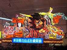
Aomori Nebuta is a famous festival performed from August 2–7 annually and is listed as one of the 100 Soundscapes of Japan by the Japanese Ministry of the Environment.[6] Besides this, major attractions of Aomori include ruins, museums, and mountains. The Hakkōda Mountains have good locations for trekking with hot spas (onsen), such as Sukayu Onsen.
- Asamushi Aquarium
- Asamushi Onsen
- Sukayu Onsen
- Aomori Bay Bridge
- Aomori Museum of Art
- Aomori City Forestry Museum
- Aomori Prefectural Museum
- Aomori City History and Folk Arts Museum
- Munakata Shiko Memorial Museum of Art
- Nebuta Museum Wa Rasse
- Sannai-Maruyama Ruins [7]
- Komakino Site
- Ōmori Katsuyama Site
- Takayashikidate Site
- Seiryū-ji
Sports
Aomori has hosted several international curling events, two in 2003 (including the Asian Winter Games), and the local women's "Team Aomori" was selected to represent Japan at the 2006 Winter Olympics in Turin, Italy and at the 2010 Winter Olympics in Vancouver, British Columbia, Canada. From March 17–25, 2007, Aomori hosted the World Women's Curling Championships.
Sports facilities
- Aomori City Baseball Stadium
- Aomori Stadium, otherwise known as Gappo Park Stadium
- Aomori Velodrome
Sister city relations


Notable people from Aomori
- Noriko Awaya, singer
- Takaharu Furukawa, archer
- Takanori Hatakeyama, professional boxer
- Yuji Hayami, science-fiction writer
- Shigeru Izumiya, entertainer
- Yaho Kitabatake, children's fiction writer
- Ichirō Kojima, photographer
- Daimaou Kosaka, comedian
- Keizo Miura, skier
- Yuichiro Miura, skier
- Shiko Munakata, woodblock artist
- Hitoshi Saito, judoka
- Kyoichi Sawada, photographer
- Akimitsu Takagi – crime fiction writer
- Bushuyama Takashi – sumo wrestler
- Kiyoshi Tanabe, professional boxer
- Shūji Terayama, modern artist
- Takanosato Toshihide, sumo wrestler
- Akiko Yano, singer-songwriter
- Daisuke Matsuzaka, Baseball player
References
- ↑ Aomori city official statistics(in Japanese)
- ↑ Aomori climate data
- ↑ "平年値(年・月ごとの値)". Kishōchō. Retrieved Jan 11, 2010.
- ↑ "観測史上1~10位の値(年間を通じての値)". Kishōchō. Retrieved Jan 11, 2010.
- ↑ Aomori population statistics
- ↑ "100 Soundscapes of Japan". Ministry of the Environment. Retrieved 8 December 2015.
- ↑ Sannai-Maruyama Site official website
- 1 2 3 4 "International Exchange". List of Affiliation Partners within Prefectures. Council of Local Authorities for International Relations (CLAIR). Archived from the original on 22 November 2015. Retrieved 8 December 2015.
External links
| Wikimedia Commons has media related to Aomori. |
| Wikivoyage has a travel guide for Aomori. |
- Official website (in Japanese)
| Core city | ||
|---|---|---|
| Cities | ||
| Districts | ||
Host cities of Asian Games | ||
|---|---|---|
| Summer | ||
| Winter | ||