Imabetsu, Aomori
| Imabetsu 今別町 | |||
|---|---|---|---|
| Town | |||
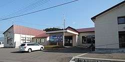 Imabestu Town Hall | |||
| |||
 Location of Imabetsu in Aomori Prefecture | |||
 Imabetsu | |||
| Coordinates: 41°10′54.4″N 140°28′54″E / 41.181778°N 140.48167°ECoordinates: 41°10′54.4″N 140°28′54″E / 41.181778°N 140.48167°E | |||
| Country | Japan | ||
| Region | Tōhoku | ||
| Prefecture | Aomori | ||
| District | Higashitsugaru | ||
| Area | |||
| • Total | 125.27 km2 (48.37 sq mi) | ||
| Population (November 30, 2017) | |||
| • Total | 2,763 | ||
| • Density | 22/km2 (57/sq mi) | ||
| Time zone | UTC+9 (Japan Standard Time) | ||
| City symbols | |||
| - Tree | Hiba | ||
| - Flower | Chrysanthemum | ||
| - Bird | Common gull | ||
| Phone number | 0174-35-2001 | ||
| Address | 167 Imabetsu, Imabetsu-machi, Higashitsugaru-gun, Aomori-ken 030-1502 | ||
| Website | Official website | ||


Imabetsu (今別町 Imabetsu-machi) is a town located in Aomori Prefecture, Japan. As of 30 November 2017, the town has an estimated population of 2,763 in 1464 households [1], and a population density of 22 persons per km2. The total area of the town is 125.27 km2 (48.37 sq mi).
Geography
Imabetsu is in Higashitsugaru District of Aomori Prefecture, and occupies the northern coastline of Tsugaru Peninsula, facing Tsugaru Strait. Much of the town is within the limits of the Tsugaru Quasi-National Park.
Neighbouring municipalities
- Aomori Prefecture
Demographics
Per Japanese census data,[2] the population of Imabetsu has decreased by more than half over the past 40 years.
| Census Year | Population |
|---|---|
| 1970 | 7,358 |
| 1980 | 7,113 |
| 1990 | 4,978 |
| 2000 | 4,124 |
| 2010 | 3,217 |
Climate
The town has a cold humid continental climate (Köppen Cfb) characterized by warm short summers and long cold winters with heavy snowfall. The average annual temperature in Imabetsu is 10.2 °C. The average annual rainfall is 1249 mm with September as the wettest month.The temperatures are highest on average in August, at around 22.9 °C, and lowest in January, at around -1.4 °C.[3]
| Climate data for Imabetsu (1981–2010) | |||||||||||||
|---|---|---|---|---|---|---|---|---|---|---|---|---|---|
| Month | Jan | Feb | Mar | Apr | May | Jun | Jul | Aug | Sep | Oct | Nov | Dec | Year |
| Average high °C (°F) | 1.4 (34.5) |
2.0 (35.6) |
5.6 (42.1) |
11.9 (53.4) |
16.5 (61.7) |
19.8 (67.6) |
23.4 (74.1) |
25.9 (78.6) |
22.8 (73) |
17.1 (62.8) |
10.4 (50.7) |
4.4 (39.9) |
13.4 (56.2) |
| Average low °C (°F) | −3.5 (25.7) |
−3.3 (26.1) |
−1.1 (30) |
3.2 (37.8) |
7.8 (46) |
12.1 (53.8) |
16.8 (62.2) |
18.9 (66) |
14.8 (58.6) |
8.8 (47.8) |
3.4 (38.1) |
−1.1 (30) |
6.4 (43.5) |
| Average precipitation mm (inches) | 136.0 (5.354) |
100.9 (3.972) |
91.6 (3.606) |
96.6 (3.803) |
105.9 (4.169) |
78.3 (3.083) |
149.7 (5.894) |
163.7 (6.445) |
171.7 (6.76) |
143.9 (5.665) |
167.9 (6.61) |
154.1 (6.067) |
1,560.3 (61.428) |
| Average snowfall cm (inches) | 171 (67.3) |
141 (55.5) |
88 (34.6) |
5 (2) |
0 (0) |
0 (0) |
0 (0) |
0 (0) |
0 (0) |
0 (0) |
14 (5.5) |
103 (40.6) |
522 (205.5) |
| Mean monthly sunshine hours | 32.2 | 55.1 | 115.1 | 177.7 | 197.7 | 169.7 | 142.2 | 158.5 | 145.0 | 133.4 | 66.9 | 33.9 | 1,427.4 |
| Source: Japan Meteorological Agency | |||||||||||||
History
The area around Imabetsu was controlled by the Tsugaru clan of Hirosaki Domain during the Edo period. During the cadastral reform of 1889, Minmaya, Kanita and Tairadate villages were separated from Imabetsu, which was also organized as a village. On March 31, 1955, Imabetsu annexed the neighboring village of Ippongi and was elevated to town status.
Economy
The economy of Imabetsu is heavily dependent on commercial fishing. Some of the locally caught seafood include sea urchin roe, sea cucumber, scallops, abalone and squid.
Education
Imabetsu has one public elementary school and one public junior high middle school operated by the town government, and one public high school operated by the Aomori Prefectural Board of Education.
Transportation
Railway
.svg.png)
.svg.png)
Highway
External links
![]()
- Official website (in Japanese)