Tsugaru, Aomori
| Tsugaru つがる市 | |||
|---|---|---|---|
| City | |||
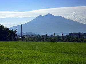 Mount Iwaki stands prominently to the southwest of Tsugaru | |||
| |||
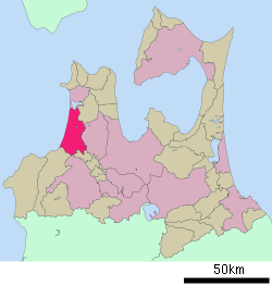 Location of Tsugaru in Aomori Prefecture | |||
 Tsugaru | |||
| Coordinates: 40°48′31.4″N 140°22′48.2″E / 40.808722°N 140.380056°ECoordinates: 40°48′31.4″N 140°22′48.2″E / 40.808722°N 140.380056°E | |||
| Country | Japan | ||
| Region | Tōhoku | ||
| Prefecture | Aomori | ||
| Area | |||
| • Total | 253.55 km2 (97.90 sq mi) | ||
| Population (December 31, 2017) | |||
| • Total | 33,254 | ||
| • Density | 130/km2 (340/sq mi) | ||
| Time zone | UTC+9 (Japan Standard Time) | ||
| - Tree | Japanese Black Pine | ||
| - Flower | Nikkōkisuge (Hemerocallis dumortieri var. esculenta) | ||
| - Bird | Common cuckoo | ||
| Phone number | 0173-42-2111 | ||
| Address | 61-1 Kizukuri Wakamidori, Tsugaru-shi, Aomori-ken 038-3192 | ||
| Website | Official website | ||


Tsugaru (つがる市 Tsugaru-shi) is a city located in Aomori Prefecture, Japan. As of 31 December 2017, the city had an estimated population of 33,254 in 13,750 households,[1] and a population density of 130 persons per km². The total area of the city is 253.55 square kilometres (97.90 sq mi). The city's name is atypical for a Japanese place, in that it is written in hiragana rather than kanji (see hiragana cities).
Geography
Tsugaru is located on the west coast of Tsugaru Peninsula, facing the Sea of Japan. The Iwaki River flows through the city. Parts of the city are within the borders of Tsugaru Quasi-National Park. The city has a cold humid continental climate (Köppen Dfb) characterized by warm short summers and long cold winters with heavy snowfall. The average annual temperature in Tsugaru is 10.6 °C. The average annual rainfall is 1298 mm with September as the wettest month.The temperatures are highest on average in August, at around 23.9 °C, and lowest in January, at around -1.3 °C.[2]
Neighbouring municipalities
- Aomori Prefecture
Demographics
Per Japanese census data,[3] the population of Tsugaru has decreased steadily over the past 40 years.
| Census Year | Population |
|---|---|
| 1970 | 50,785 |
| 1980 | 46,869 |
| 1990 | 43,699 |
| 2000 | 41,320 |
| 2010 | 37,243 |
History
A "Lord Tsugaru" has been mentioned in folklore along with Harada Kurando involving fencing and a tale of a "white serpent God."[4] The area of Tsugaru was part of the holdings of the Tsugaru clan of Hirosaki Domain in the Edo period. After the Meiji restoration, the area was organised into Nishitsugaru District, Aomori.
The modern city of Tsugaru was established on February 11, 2005, from the merger of the town of Kizukuri, and the villages of Inagaki, Kashiwa, Morita and Shariki (all from Nishitsugaru District).
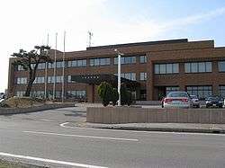
Government
Tsugaru has a mayor-council form of government with a directly elected mayor and a unicameral city legislature of 20 members.
Economy
The economy of Tsugaru is heavily dependent on agriculture and commercial fishing. The city serves as a minor regional commercial center. Agricultural produce includes rice, apples, melons, watermelons, and Brasenia.
Education
Tsugaru has ten public elementary schools and five public junior high schools operated by the city government, and one public high school operated by the Aomori Prefectural Board of Education. The prefecture also operates one special education school.
Transport
Railway
.svg.png)
- Kizukuri - Nakata - Mutsu-Morita - Koshimizu
Highway
Local Attractions
- Takayama Inari Shrine
- Kamegaoka Stone Age Site, a National Historic Site
- Tagoyano Shell Mound. a National Historic Site
Sister city relations


Noted people from Tsugaru
- Shunkichi Takeuchi, politician, former Aomori governor
- Gento Uehara, songwriter
- Kenroku Uehara, songwriter
- Leo Matsumoto, actress
- Ryuhei Toyama, actor
The town has produced many top sumo wrestlers over the years.[6] Among them are:
- Wakanohana Kanji I, yokozuna
- Takanosato Toshihide, yokozuna
- Asahifuji Seiya, yokozuna
- Wakanosato Shinobu, sekiwake
References
- ↑ official home page(in Japanese)
- ↑ Tsugaru climate data
- ↑ Tsugaru population statistics
- ↑ The Oriental Economic Review. Oriental Information Agency. 1912-01-01.
- ↑ "US-Japan Sister Cities by State". Asia Matters for America. Honolulu, HI: East-West Center. Retrieved 20 November 2015.
- ↑ "Sumo Town Strives for Comeback". NHK World. 2 Dec 2014. Retrieved 29 July 2015.
External links
| Wikimedia Commons has media related to Tsugaru, Aomori. |
- Official website (in Japanese)