Hsinchu County
| Hsinchu County 新竹縣 | |||
|---|---|---|---|
| County | |||
 | |||
| |||
 | |||
| Coordinates: 24°50′0″N 121°0′53″E / 24.83333°N 121.01472°ECoordinates: 24°50′0″N 121°0′53″E / 24.83333°N 121.01472°E | |||
| Country | Republic of China (Taiwan) | ||
| Region | Northwestern Taiwan | ||
| Seat | Zhubei City | ||
| Largest city | Zhubei City | ||
| Boroughs | 1 cities, 12 (3 urban, 9 rural) townships | ||
| Government | |||
| • County Magistrate | Chiu Ching-chun (KMT) | ||
| Area | |||
| • Total | 1,427.59 km2 (551.20 sq mi) | ||
| Area rank | 12 of 22 | ||
| Population (January 2017) | |||
| • Total | 547,794 | ||
| • Rank | 11 of 22 | ||
| • Density | 380/km2 (990/sq mi) | ||
| Time zone | UTC+8 (National Standard Time) | ||
| Website | www.hsinchu.gov.tw | ||
| Symbols | |||
| Bird | Muller's barbet (Megalaima oorti) | ||
| Flower | Camellia | ||
| Tree | Broad-leaved podocarpus (Nageia nagi) | ||

| Hsinchu County | |||||||||||||||
| Traditional Chinese | 新竹縣 | ||||||||||||||
|---|---|---|---|---|---|---|---|---|---|---|---|---|---|---|---|
| |||||||||||||||
Hsinchu County (Chinese: 新竹縣; pinyin: Xīnzhú Xiàn; Wade–Giles: Hsin1-chu2 Hsien4) is a county in north-western Taiwan. The population of the county is mainly Hakka; there is a Taiwanese aboriginal minority in the southeastern part of the county. Zhubei is the county capital, where the government office and county office is located. A portion of the Hsinchu Science Park is located in Hsinchu County.
History
Before the arrival of Han people, the Hsinchu area was the homeland of Taokas Pingpu, Saisiyat, and Atayal tribes. In 1626, after Spain occupied northern Taiwan, Spanish missionaries arrived at Teckcham (Chinese: 竹塹; Pe̍h-ōe-jī: Tek-khàm). Fukienese (Hoklo) and Hakka people came during the Ming Dynasty era (1368-1644) and began to cultivate the land from the plains near the sea towards the river valleys and hills. After the ousting of the Dutch is 1662, the Kingdom of Tungning ruled part of southwestern Taiwan until 1683.
Qing Dynasty
In 1684, Zhuluo County was established during Qing Dynasty rule, and Han people again cultivated the Teckcham area. Teckcham was first settled by Han Chinese in 1711 and renamed Hsinchu in 1875.[1] Hsinchu was a part of Taipeh Prefecture. In the late 19th century, Hoklo people dominated the coastal plain area, forcing the Saisiyat and Atayal tribes to move to Jianshi and Wufeng area, while the Hakka and Taokas plains tribes settled together in the river valleys and hills area.
Empire of Japan
In 1920, during the Japanese rule of Taiwan, Shinchiku Prefecture covered the areas of modern-day Hsinchu County, in addition to Hsinchu City, Miaoli County and Taoyuan City.
Republic of China
After the handover of Taiwan from Japan to the Republic of China on 25 October 1945, Hsinchu County was established to be part of Taiwan Province on 25 December 1945. At that time, more and more people moved with the Republic of China Armed Forces from Mainland China to Taiwan for work, marriage and to stay out of the Chinese Civil War, in which they formed a new social group in the society.[2] On 1 July 1982, Xiangshan Township of the county was taken out from Hsinchu County and incorporated to Hsinchu City and became a district.
Geography
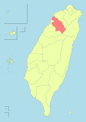
Hsinchu County is located at the northwest part of Taiwan Island. It borders Taoyuan City to the north, Miaoli County to the south, Taiwan Strait to the west and Xueshan and Dabajian Mountain to the east. With an area spanning up to 1,427.59 km2 (551.20 sq mi), Hsinchu County area composed mainly of uplands, tablelands and mountains, except for the alluvial plains of the Fengshan River and Touqian River mouth area and partial ancient river land.[2]
Climate
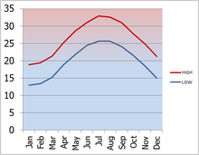
The average climate in Hsinchu County is mild.[3]
Administration
Hsinchu County controls 1 city, 3 urban townships, 6 rural townships and 2 mountain indigenous townships.[4] Zhubei City is the seat of Hsinchu County which houses the Hsinchu County Government and Hsinchu County Council. The incumbent Magistrate of Hsinchu County is Chiu Ching-chun of the Kuomintang. The administrative division of the county are:
| Type | Name | Chinese | Hokkien | Hakka | Formosan |
|---|---|---|---|---|---|
| City | Zhubei City | 竹北市 | Tek-pak | Tsuk-pet | |
| Urban townships |
Guanxi | 關西鎮 | Koan-se | Kûan-sî | Atayal |
| Xinpu | 新埔鎮 | Sin-po͘ | Sîn-phû | ||
| Zhudong | 竹東鎮 | Tek-tang | Tsuk-tûng | ||
| Rural townships |
Baoshan | 寶山鄉 | Pó-san | Pó-sân | |
| Beipu | 北埔鄉 | Pak-po͘ | Pet-phû | ||
| Emei | 峨眉鄉 | Gô-bî | Ngô-mì | ||
| Hengshan | 橫山鄉 | Hoâiⁿ-san | Vàng-sân | ||
| Hukou | 湖口鄉 | Ô͘-kháu | Fù-khiéu | ||
| Qionglin | 芎林鄉 | Khiông-nâ | Khiûng-lìm | ||
| Xinfeng | 新豐鄉 | Sin-hong | Sîn-fûng | ||
| Mountain indigenous townships |
Jianshi | 尖石鄉 | Chiam-chio̍h | Tsiâm-sa̍k | Atayal |
| Wufeng | 五峰鄉 | Ngó͘-hong | Ńg-fûng | Atayal, Saisiyat |
Colors indicate the common language status of Hakka and Formosan languages within each division.
Demographics
| Historical population | ||
|---|---|---|
| Year | Pop. | ±% |
| 1985 | 366,566 | — |
| 1990 | 374,492 | +2.2% |
| 1995 | 408,577 | +9.1% |
| 2000 | 439,713 | +7.6% |
| 2005 | 487,692 | +10.9% |
| 2010 | 513,015 | +5.2% |
| 2015 | 542,042 | +5.7% |
| Source:"Populations by city and country in Taiwan". Ministry of the Interior Population Census. | ||
The population of the county consists of Hakka, Hoklo, aborigines and new immigrants. The Hakka people constituted around 84% of the total population in 2014, while the aborigines consisted mainly of Atayal and Saisiyat people.[5] As of January 2017, the total population was 547,794, with 267,599 females and 280,195 males in 187,644 households.[6]
Economy
High tech industry
After the founding of Hsinchu Science Park in 1980, a high number of high-tech industries began to grow and expand outside the park, attracting workers coming to work and settle in the county.
Education
Education in Hsinchu County is administered by the Education Department of Hsinchu County Government. The county is home to the Minghsin University of Science and Technology and Ta Hwa University of Science and Technology.
Energy
Power generations
Hsinchu County is home to the gas-fired Hsintao Power Plant with a capacity of 600 MW located in Guanxi Township.
Water supply
Hsinchu County houses the Baoshan Dam, supplying cooling water for factories in the Hsinchu Science Park and neighboring Hsinchu City. The dam can contain water up to 5,470,000 m3 with a catchment area of 3.2 km2 (1.2 sq mi).
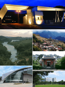
Tourist attractions
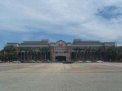
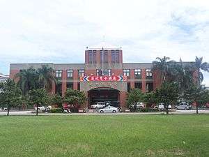
- Beipu Citian Temple
- Mount Dabajian
- Former Residence of Zhang Xueliang
- Green World Ecological Farm
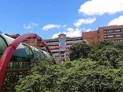
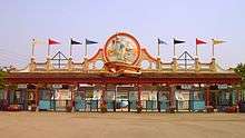
- Leofoo Village Theme Park
- Little Ding-Dong Science Theme Park
- Rueylong Museum
- Shei-Pa National Park
- Tapung Old Fort
- Zhudong Animation and Comic Creative Park
- Zhudong Timber Industry Exhibition Hall
- Beipu Old Street
- Neiwan Old Street
- Emei Huge Buddha Statue
Transportation

Rail
The Hsinchu Station of the Taiwan High Speed Rail is located in the county at Zhubei City. Hsinchu County is crossed by three Taiwan Railways Administration lines, which are the Liujia Line, Neiwan Line and Western Line.
Relative location
Places adjacent to Hsinchu County | ||||||||||
|---|---|---|---|---|---|---|---|---|---|---|
| ||||||||||
References
- ↑ Wang, Erika (25 October 2007). "Hsinchu owns rich history, culture and natural resources". The China Post. Retrieved 30 November 2014.
- 1 2 "Archived copy". Archived from the original on 23 June 2014. Retrieved 28 May 2014.
- ↑ "Hsinchu County Government Hsinchu County Government". Hsinchu County Government.
- ↑ "Towns & Townships". hsinchu.gov.tw. Hsinchu County Gov't. Retrieved 4 February 2017.
- ↑ "Population". hsinchu.gov.tw. Hsinchu County Government. Retrieved 27 February 2017.
- ↑ 106年1月 新竹縣人口統計報表 [Table of Hsinchu County Population Statistics, January 2017]. hsinchu.gov.tw (in Chinese). Hsinchu County Government. Retrieved 27 February 2017.
External links
| Wikimedia Commons has media related to Hsinchu County. |
- Hsinchu County Government website (in Chinese)
- Hsinchu County Government website (in English)
Cities and townships of Hsinchu County | ||
|---|---|---|
| Cities | | |
| Urban townships | ||
| Rural townships | ||
| Mountain indigenous townships | ||
| Special municipalities (6) |  | |
|---|---|---|
| Cities (3) | ||
| Counties (13) | ||
| ||