Noheji, Aomori
| Noheji 野辺地 | |||
|---|---|---|---|
| Town | |||
 Noheji Town Hall | |||
| |||
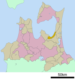 Location of Noheji in Aomori Prefecture | |||
 Noheji | |||
| Coordinates: 40°51′52″N 141°07′43.5″E / 40.86444°N 141.128750°ECoordinates: 40°51′52″N 141°07′43.5″E / 40.86444°N 141.128750°E | |||
| Country | Japan | ||
| Region | Tōhoku | ||
| Prefecture | Aomori Prefecture | ||
| District | Kamikita | ||
| Area | |||
| • Total | 81.68 km2 (31.54 sq mi) | ||
| Population (Febrjuary 28, 2017) | |||
| • Total | 13,728 | ||
| • Density | 168/km2 (440/sq mi) | ||
| Time zone | UTC+9 (Japan Standard Time) | ||
| - Tree | Sakura | ||
| - Flower | Rosa rugosa | ||
| - Bird | Common gull | ||
| Phone number | 0175-64-2111 | ||
| Address |
Noheiji 123-1, Kitakami-gun, Aomori-ken 039-3131 | ||
| Website |
www | ||


Noheji (野辺地町 Noheji-machi) is a town located in Aomori Prefecture, Japan. As of 28 February 2017, the town had an estimated population of 13,728, and a population density of 168 persons per km² in 6,556 households.[1] The total area of the town is 81.68 square kilometres (31.54 sq mi).[2]
Geography
Noheji occupies the southeastern coastline of Mutsu Bay at the base of the Shimokita Peninsula. The village has a cold maritime climate characterized by cool short summers and long cold winters with heavy snowfall (Köppen climate classification Cfa). The average annual temperature in Noheji is 9.8 °C. The average annual rainfall is 1243 mm with September as the wettest month.The temperatures are highest on average in August, at around 22.7 °C, and lowest in January, at around -2.1 °C.[3]
Neighbouring municipalities
Demographics
Per Japanese census data,[4] the population of Noheji has declined over the past 40 years.
| Census Year | Population |
|---|---|
| 1970 | 17,544 |
| 1980 | 18,419 |
| 1990 | 16,750 |
| 2000 | 16,012 |
| 2010 | 14,304 |
History
The area around Noheji was inhabited by the Emishi people until the historical period, and the name “Noheji” is derived from “Nosobechi”, or “place where a pure river flows through a field” in the Ainu language. During the Edo period, the area was controlled by the Nambu clan of Morioka Domain and prospered due to its fishing industry and location on the road connecting Morioka Domain with the Hirosaki Domain. During the Boshin War of the Meiji Restoration, the Battle of Noheji occurred between the Tokugawa loyalist forces of Morioka Domain and pro-imperial forces of Hirosaki Domain on November 11, 1868. During the post-Meiji restoration cadastral reform of April 1, 1889, Noheiji Village was proclaimed. Noheji was elevated to town status on August 28, 1898.
Economy
The economy of Noheji is heavily dependent on commercial fishing, especially for scallops, and on agriculture with the raising of mountain yams predominating. The town also serves as a commercial and transportation center for the surrounding rural areas.
Education
Noheji has three public elementary schools and two public middle schools operated by the town government, and one public high school operated by the Aomori Prefectural Board of Education. The town also has one private high school.
Transportation
Railway
Highway
Local attractions
- Makado Onsen, a hot spring and ski resort
Noted people from Noheji
- Tsuyoshi Ichinohe – skier
- Takaya Eguchi - modern dancer
- Gaku Shibasaki - footballer
References
- ↑ Official home page
- ↑ "詳細データ 青森県野辺地町". 市町村の姿 グラフと統計でみる農林水産業 (in Japanese). Ministry of Agriculture, Forestry and Fisheries. 2016. Retrieved 13 July 2017.
- ↑ Noheiji climate data
- ↑ Noheji population statistics
External links
- Official Website (in Japanese)
| Wikimedia Commons has media related to Noheji, Aomori. |