Ajigasawa, Aomori
| Ajigasawa 鰺ヶ沢町 | |||
|---|---|---|---|
| Town | |||
 Ajigasawa Town | |||
| |||
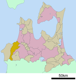 Location of Ajigasawa in Aomori Prefecture | |||
 Ajigasawa | |||
| Coordinates: 40°46′47.7″N 140°12′31.2″E / 40.779917°N 140.208667°ECoordinates: 40°46′47.7″N 140°12′31.2″E / 40.779917°N 140.208667°E | |||
| Country | Japan | ||
| Region | Tōhoku | ||
| Prefecture | Aomori | ||
| District | Nishitsugaru | ||
| Area | |||
| • Total | 343.08 km2 (132.46 sq mi) | ||
| Population (October 2017) | |||
| • Total | 10,330 | ||
| • Density | 30/km2 (78/sq mi) | ||
| Time zone | UTC+9 (Japan Standard Time) | ||
| Symbols | |||
| • Tree | Keyaki | ||
| • Flower | Rosa rugosa | ||
| • Bird | Japanese bush-warbler | ||
| Phone number | 0173-72-2111 | ||
| Address | 209 Honcho, Ajigasawa-machi, Nishitsugaru-gun, Aomori-ken 038-2792 | ||
| Website | Official website | ||


Ajigasawa (鰺ヶ沢町 Ajigasawa-machi) is a town located in Aomori Prefecture, Japan. As of 30 October 2017, the town had an estimated population of 10,330 in 4612 households,[1] and a population density of 30 persons per km2. The total area of the town is 343.08 square kilometres (132.46 sq mi).
Geography
Ajigasawa is in Nishitsugaru District, Aomori southwestern corner of Aomori Prefecture on the border with Akita Prefecture, facing the Sea of Japan to the north, and Mount Iwaki to the east. Part of the town is located within the borders of the Shirakami-Sanchi, a UNESCO World Heritage Site, and some coastal areas of the town are within the Tsugaru Quasi-National Park. The Akaishi Keiryū Anmon no Taki Prefectural Natural Park is also partly located within the borders of Ajigasawa.
Neighbouring municipalities
Demographics
Per Japanese census data,[2] the population of Ajigasawa has decreased by more than half over the past 40 years.
| Census Year | Population |
|---|---|
| 1970 | 18,439 |
| 1980 | 17,402 |
| 1990 | 14,899 |
| 2000 | 13,551 |
| 2010 | 11,449 |
Climate
The town has a cold humid continental climate (Köppen Dfb) characterized by warm short summers and long cold winters with heavy snowfall. The average annual temperature in Ajigasawa is 8.9 °C. The average annual rainfall is 1480 mm with September as the wettest month.The temperatures are highest on average in August, at around 22.9 °C, and lowest in January, at around -3.1 °C.[3]
History
The area around Ajigasawa was controlled by the Tsugaru clan of Hirosaki Domain during the Edo period. Oura Mitsunobu, the founder of the Tsugaru clan, settled in Tanesato (now part of Ajigasawa) in 1491, which developed into a port for the Tsugaru region. Ajigasawa became a village in the Nishitsugaru District in 1889, and was elevated to town status on March 31, 1955, by annexing the neighboring villages of Akaishi, Nakamura, Narusawa and Maido.
Economy
The economy of Ajigasawa is heavily dependent on agriculture (rice and horticulture) and on commercial fishing, especially for squid. Other species commonly caught in the local waters include the Japanese flounder, Japanese horse mackerel, Atka mackerel, red snapper, cod, angler fish, octopus, sharks and salmon.
Education
Ajigasawa has three public elementary schools and three public junior high schools operated by the town government and one public high school operated by the Aomori Prefectural Board of Education.
The Shirakami Nature School is a non-profit organization that is housed in a 19th-century wooden building that was used as an elementary school until the spring of 2003. The Shirakami Nature School hosts a wide variety of environmental education including classroom activities and open-air classes to people of all ages.
Transportation
Railway
.svg.png)
Highway
International relations

Local attractions
- The Kikuya squid stand on the outskirts of town is the home of Wasao, an Akita dog that garnered nationwide attention after starring in a 2011 feature film which was filmed on location in the town.
- NAQUA Shirakami Ski Resort.
- Ajigasawa Beach is about a ten-minute walk from the train station and has both grass and sand areas with a view of the Sea of Japan.
- Umi No Eki “Wando” is a collection of stores, much like a market, that sells local goods directly from the farmers and fishermen. The products sold here are all local, and very fresh.
- Shirakami-Sanchi – UNESCO World Heritage Site
- Otaka-yama park is open to the public and includes a multipurpose stadium, tennis courts, amphitheater, go-carts and an elaborate playground.
- Kurokuma Falls (くろくまの滝 Kurokuma no taki), gets its name from its appearance; it looks like a standing black bear. It is one of Japan’s Top 100 Waterfalls.
- ruins of Tanesato Castle, a National Historic Site
- Akaishi Keiryū Anmon no Taki Prefectural Natural Park
Noted people from Ajigasawa
- Mainoumi Shuhei, sumo wrestler
- Homarefuji Yoshiyuki, sumo wrestler
Gallery
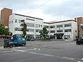
- Ajigasawa Town Office
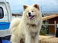 Wasao
Wasao Kurokuma Falls
 Rice fields near Minami Kanazawa
References
- ↑ official home page(in Japanese)
- ↑ Ajigasawa population statistics
- ↑ Ajigasawa climate data
- ↑ "International Exchange". List of Affiliation Partners within Prefectures. Council of Local Authorities for International Relations (CLAIR). Archived from the original on 2015-11-22. Retrieved 21 November 2015.
External links
![]()
- Official website (in Japanese)
- Shirakami Nature School Mountain Guide
| Core city | ||
|---|---|---|
| Cities | ||
| Districts | ||
| Authority control |
|---|