Tōhoku region
| Tōhoku region 東北地方 | |
|---|---|
| Region | |
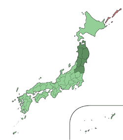 The Tōhoku region in Japan | |
| Area | |
| • Total | 66,889.55 km2 (25,826.20 sq mi) |
| Population (2015)[1] | |
| • Total | 9,020,531 |
| • Density | 130/km2 (350/sq mi) |
| Time zone | UTC+9 (JST) |
The Tōhoku region (東北地方 Tōhoku-chihō), Northeast region, or Northeast Japan consists of the northeastern portion of Honshu, the largest island of Japan. This traditional region consists of six prefectures (ken): Akita, Aomori, Fukushima, Iwate, Miyagi, and Yamagata.[2]
Tōhoku retains a reputation as a remote, scenic region with a harsh climate. In the 20th century, tourism became a major industry in the Tōhoku region.
History
In mythological times, the area was known as Azuma (吾妻, あづま) and corresponded to the area of Honshu occupied by the native Ainu. The area was historically the Dewa and the Michinoku regions,[3] a term first recorded in Hitachi-no-kuni Fudoki (常陸国風土記) (654). There is some variation in modern usage of the term "Michinoku".[4]
Tōhoku's initial historical settlement occurred between the seventh and ninth centuries, well after Japanese civilization and culture had become firmly established in central and southwestern Japan. The last stronghold of the indigenous Emishi on Honshu and the site of many battles, the region has maintained a degree of autonomy from Kyoto at various times throughout history.
The haiku poet Matsuo Bashō wrote Oku no Hosomichi (The Narrow Road to the Deep North) during his travels through Tōhoku.
The region is traditionally known as a less developed area of Japan.[5]
The catastrophic 9.0-Magnitude earthquake and tsunami on March 11, 2011, inflicted massive damage along the east coast of this region, killed 15,894[6] people and was the costliest natural disaster ever which left 500,000 people homeless along with radioactive fallout from the Fukushima Daiichi nuclear disaster.

Christianity in Tōhoku
Masamune, feudal lord of Date clan, expanded trade in the Tōhoku region. Although initially faced with attacks by hostile clans, he managed to overcome them after a few defeats and eventually ruled one of the largest fiefdoms of the later Tokugawa shogunate. He built many palaces and worked on many projects to beautify the region. He is also known to have encouraged foreigners to come to his land. Even though he funded and promoted an envoy to establish relations with the Pope in Rome, he was likely motivated at least in part by a desire for foreign technology, similar to that of other lords, such as Oda Nobunaga. Further, once Tokugawa Ieyasu outlawed Christianity, Masamune reversed his position, and though disliking it, let Ieyasu persecute Christians in his domain. For 270 years, Tōhoku remained a place of tourism, trade and prosperity. Matsushima, for instance, a series of tiny islands, was praised for its beauty and serenity by the wandering haiku poet Matsuo Bashō.
He showed sympathy for Christian missionaries and traders in Japan. In addition to allowing them to come and preach in his province, he also released the prisoner and missionary Padre Sotelo from the hands of Tokugawa Ieyasu. Date Masamune allowed Sotelo as well as other missionaries to practice their religion and win converts in Tōhoku.
Subdivision
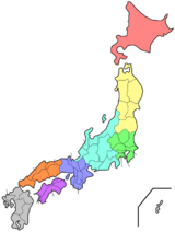
The most often used subdivision of the region is dividing it to "North Tōhoku" (北東北 Kita-Tōhoku) consisting of Aomori, Akita, and Iwate Prefectures and "South Tōhoku" (南東北 Minami-Tōhoku) consisting of Yamagata, Miyagi, and Fukushima Prefectures.
Population development
| Historical population | ||
|---|---|---|
| Year | Pop. | ±% |
| 1884 | 3,957,085 | — |
| 1898 | 4,893,747 | +23.7% |
| 1920 | 5,793,974 | +18.4% |
| 1940 | 7,164,674 | +23.7% |
| 1950 | 9,021,809 | +25.9% |
| 1955 | 9,334,442 | +3.5% |
| 1970 | 9,031,197 | −3.2% |
| 1975 | 9,232,875 | +2.2% |
| 1980 | 9,572,088 | +3.7% |
| 1985 | 9,730,352 | +1.7% |
| 1990 | 9,738,284 | +0.1% |
| 1995 | 9,834,124 | +1.0% |
| 2000 | 9,817,589 | −0.2% |
| 2010 | 9,335,636 | −4.9% |
| 2018 | 8,768,559 | −6.1% |
| Note: All figures since 1920 are October, except 2018 which is Apr. Source: Japan Census figures except latest which from ja:東北地方 | ||
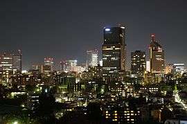
The population collapse of Tōhoku, which began before the year 2000, has accelerated, now including previously dynamic Miyagi. Despite this, Sendai City has grown due to the disaster. The population collapse of Aomori, Iwate and Akita Prefectures, Honshu's 3 northernmost, began in the early 1980s after an initial loss of population in the late 1950s. Fukushima Prefecture, prior to 1980, had traditionally been the most populated, but today Miyagi is the most populated and urban by far.
Geography

Tōhoku, like most of Japan, is hilly or mountainous, with the Ōu Mountains running north-south. The inland location of many of the region's lowlands has led to a concentration of much of the population there. Coupled with coastlines that do not favor seaport development, this settlement pattern resulted in a much greater than usual dependence on land and rail transportation. Low points in the central mountain range make communications between lowlands on either side of the range moderately easy.
Tōhoku was traditionally considered the granary of Japan because it supplied Sendai and the Tokyo-Yokohama market with rice and other farming commodities. Tōhoku provided 20 percent of the nation's rice crop. The climate, however, is harsher than in other parts of Honshū due to the stronger effect of the Siberian High, and permits only one crop a year on paddy fields.
In the 1960s, iron, steel, cement, chemical, pulp, and petroleum refining industries began developing.
Cities and populated areas
- Designated cities
- Sendai (population: 1,045,000)
- Core cities
- Iwaki (population: 333,000)
- Koriyama (population: 331,000)
- Akita (population: 322,000)
- Morioka (population: 300,000)
- Aomori (population: 297,000)
- Hachinohe (population: 234,000)
- Other cities
- Aizuwakamatsu
- Daisen
- Date
- Fukushima
- Goshogawara
- Hachimantai
- Hanamaki
- Higashimatsushima
- Higashine
- Hirakawa
- Hirosaki
- Ichinoseki
- Ishinomaki
- Iwanuma
- Kakuda
- Kamaishi
- Kaminoyama
- Katagami
- Kazuno
- Kesennuma
- Kitaakita
- Kitakami
- Kitakata
- Kuji
- Kurihara
- Kuroishi
- Minamisōma
- Misawa
- Miyako
- Motomiya
- Murayama
- Mutsu
- Nagai
- Nan'yō
- Natori
- Nihonmatsu
- Nikaho
- Ninohe
- Noshiro
- Obanazawa
- Oga
- Ōdate
- Ōfunato
- Ōsaki
- Ōshū
- Rikuzentakata
- Sagae
- Sakata
- Semboku
- Shinjō
- Shiogama
- Shirakawa
- Shiroishi
- Sōma
- Sukagawa
- Tagajō
- Takizawa
- Tamura
- Tendō
- Tome
- Tomiya
- Tōno
- Towada
- Tsugaru
- Tsuruoka
- Yamagata
- Yokote
- Yonezawa
- Yurihonjō
- Yuzawa
Points of interest
Natural features
Parks
See also
Notes
- ↑ Ministry of Internal Affairs and Communications Statistics Bureau (26 October 2011). "平成 22 年国勢調査の概要" (PDF). Retrieved 6 May 2012.
- ↑ Nussbaum, Louis-Frédéric. (2005). "Tōhoku" in Japan Encyclopedia, p. 970, p. 970, at Google Books
- ↑ Hanihara, Kazuro. "Emishi, Ezo and Ainu: An Anthropological Perspective," Japan Review, 1990, 1:37 (PDF p. 3).
- ↑ McCullough, Helen Craig. (1988). The Tale of the Heike, p. 81, p. 81, at Google Books; excerpt, "Furthermore, in the old days, the two famous eastern provinces, Dewa and Michinoku, were a single province made up of sixty-six districts, of which twelve were split off to create Dewa."
- ↑ Dentsu. (1970). Industrial Japan, Issues 18-26, p. 58; retrieved 2013-4-17.
- ↑ "National Police Agency of Japan Damage Situation and Police Countermeasures associated with 2011Tohoku district - off the Pacific Ocean Earthquake" (PDF). March 10, 2016.
References
- Nussbaum, Louis-Frédéric and Käthe Roth. (2005). Japan encyclopedia. Cambridge: Harvard University Press. ISBN 978-0-674-01753-5; OCLC 58053128

External links

- Akita Prefecture Official website (in English)
- Aomori Prefecture Official website
- Fukushima Prefecture Official website (in English)
- Miyagi Prefecture Official website (in English)
- Yamagata Prefecture Official website (in English)
- Iwate Prefecture Living Guide for Foreign Nationals (in English)
| Geology | |||||||||||||||
|---|---|---|---|---|---|---|---|---|---|---|---|---|---|---|---|
| Affected areas |
| ||||||||||||||
| Affected infrastructure |
| ||||||||||||||
| Nuclear Accidents and Incidents |
| ||||||||||||||
| Foreshocks, Aftershocks |
| ||||||||||||||
| People | |||||||||||||||
| Relief and Recovery |
| ||||||||||||||
| Media |
| ||||||||||||||
| Other | |||||||||||||||