Hakkōda Mountains
| Hakkōda Mountains | |
|---|---|
|
八甲田山系 Hakkōda-sankei | |
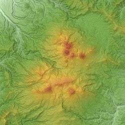
 The Hakkōda Mountains viewed from southeast. | |
| Highest point | |
| Peak | Mount Ō |
| Elevation | 1,584 m (5,197 ft) |
| Coordinates | 40°39′22″N 140°52′51″E / 40.65611°N 140.88083°ECoordinates: 40°39′22″N 140°52′51″E / 40.65611°N 140.88083°E |
| Geography | |
| Country | Japan |
| State | Aomori Prefecture |
| Region | Tōhoku |
| Parent range | Ōu Mountains |
| Biome | Alpine climate |
| Geology | |
| Orogeny | Island arc |
| Type of rock | Volcanic |
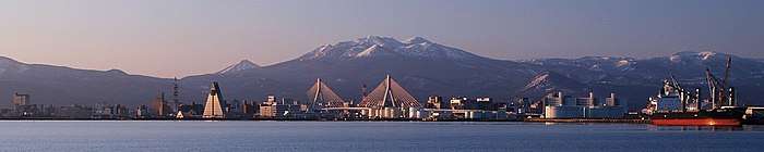
The Hakkōda Mountains (八甲田山系 Hakkōda-sankei) is a volcanic mountain range that lies to the south of Aomori city in Aomori Prefecture, Japan. The range consists of more than a dozen stratovolcanoes and lava domes arranged into two volcanic groups.[1] The Northern Hakkōda Volcanic Group emerges from the rim of an 8-km wide caldera that dates back to the Pleistocene.[1] The Southern Hakkōda Volcanic Group predates the caldera.[2]
Description
The highest peak in the range is Mount Ōdake, which can be climbed from Sukayu Onsen in about four hours. Heavy snowfall makes Hakkoda a prime destination for backcountry and mountain skiers, and there are two mountain huts for overnight trips. The lower slopes of the mountains are forested interspersed with moorland. Above 1300 meters,[3] the Alpine climate zone starts.
The Hakkōda Mountains, along with Lake Towada and the Oirase Valley make up the Towada-Hachimantai National Park.[3]
Geology
The volcanic peaks are made of non-alkali mafic rock;[4] mostly andesite, dacite, and basalt.[2] Although both groups of mountains formed in the Pleistocene, the southern group is older than the northern group. The southern group is made from rock that is 700,000 to 1,700,000 years old, while the northern group is made from rock that is 13,000 to 700,000 years old.[4]
List of peaks
The following is a list of peaks and their heights:[3]
- Northern Group:
- Mount Ōdake (大岳 Ō-dake) 1585 m
- Mount Takada-Ōdake (高田大岳 Takada-Ō-dake) 1552 m
- Mount Idodake (井戸岳 Ido-dake)[1] 1537 m
- Mount Akakuradake (赤倉岳 Akakura-dake) 1521 m
- Mount Kodake (小岳 Ko-dake) 1478 m
- Mount Iōdake (硫黄岳 Iō-dake) 1360 m
- Mount Tamoyachidake (田茂萢岳 Tamoyachi-dake) 1324 m
- Mount Maedake (前嶽 Mae-dake) 1251.7 m
- Mount Hinadake (雛岳 Hina-dake) 1240.3 m
- Mount Ishikuradake (石倉岳 Ishikura-dake) 1202 m
- Mount Tsurugi
- Southern Group:
- Kushi Summit (櫛ヶ峯 Kushi-ga-mine) 1516.5 m
- Includes Mount Kamidake (上岳 Kami-dake) 1516.5 m and Mount Shimodake (下岳 Shimo-dake) 1342 m
- Mount Norikuradake (乗鞍岳 Norikuradake) 1450 m
- Koma Summit (駒ヶ峯 Koma-ga-mine) 1416 m
- Mount Sarukuradake (猿倉岳 Sarukura-dake) 1353.6 m
- Mount Yokodake (横岳 Yoko-dake) 1339.4 m
- Mount Akakuradake (赤倉岳 Akakura-dake) 1290 m
- Mount Minamizawadake (南沢岳 Minamizawa-dake) 1198.8 m
- Mount Sakasagawadake (逆川岳 Sakasagawa-dake) 1183 m
- Kushi Summit (櫛ヶ峯 Kushi-ga-mine) 1516.5 m
Wetlands
The Hakkōda Mountain are famous for their high-altitude wetlands:
- Sennnin Wetland (仙人岱)
- Kenashi Wetlands (毛無岱)
- Tamo Wetland (田茂萢)
- Suiren Lake (睡蓮沼)
- Tashiro Plateau Wetland (田代平湿原)
Disaster of the Fifth Infantry Group
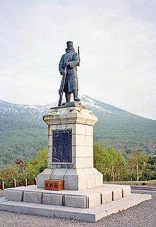
The Hakkōda Mountains incident occurred on January 23, 1902, when a group of Imperial Japanese Army soldiers marched in a blizzard on the Hakkōda Mountains en route to Tashiro Hot Spring located in the Hakkōda Mountains. The 199 deaths during a single ascent make it the world's largest mountaineering disaster in the modern history of mountain climbing.
References
- 1 2 3 "Hakkoda Group". Global Volcanism Program. Smithsonian National Museum of Natural History. Retrieved 2008-09-13.
- 1 2 "HAKKODA Caldera". Quaternary Volcanoes of Japan. National Institute of Advanced Industrial Science and Technology. 2006. Archived from the original on 2012-12-19. Retrieved 2008-09-13.
- 1 2 3 Hunt, Paul (1988). "27. Hakkōda Mountains". Hiking in Japan: An Adventurer's Guide to the Mountain Trails (First ed.). Tokyo and New York: Kodansha International. pp. 172–175. ISBN 0-87011-893-5.
- 1 2 "Northern Tohoku". Seamless digital geological map of Japan 1:200,000. Geological Survey of Japan, AIST. May 12, 2007. Retrieved 2008-09-16.
See also
External links
| Wikimedia Commons has media related to Hakkōda Mountains. |
- "Hakkodasan: National catalogue of the active volcanoes in Japan" (PDF). - Japan Meteorological Agency
- Hakkodasan - Smithsonian Institution: Global Volcanism Program
| Hokkaidō | |||||||||
|---|---|---|---|---|---|---|---|---|---|
| Tōhoku region Jōshinetsu region |
| ||||||||
| Kantō region | |||||||||
| Chūbu region |
| ||||||||
| Western Japan | |||||||||
| |||||||||