Jōetsu, Niigata
| Jōetsu 上越市 | |||
|---|---|---|---|
| Special city | |||
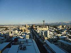 Sunrise over Takada | |||
| |||
 Location of Jōetsu in Niigata | |||
 Jōetsu | |||
| Coordinates: 37°8′52.3″N 138°14′9.9″E / 37.147861°N 138.236083°ECoordinates: 37°8′52.3″N 138°14′9.9″E / 37.147861°N 138.236083°E | |||
| Country | Japan | ||
| Region | Chūbu (Kōshin'etsu) (Hokuriku) | ||
| Prefecture | NIigata | ||
| Government | |||
| • Mayor | Hideyuki Murayama | ||
| Area | |||
| • Total | 973.81 km2 (375.99 sq mi) | ||
| Population (October 2018) | |||
| • Total | 193,517 | ||
| • Density | 200/km2 (510/sq mi) | ||
| Time zone | UTC+9 (Japan Standard Time) | ||
| Symbols | |||
| • Tree | Sakura | ||
| • Flower | Camellia | ||
| Phone number | 025-526-5111 | ||
| Address | 1-1-3 Kida, Jōetsu-shi, Niigata-ken 943-8601 | ||
| Website | Template:Offiical | ||


Jōetsu (上越市 Jōetsu-shi) is a city located in Niigata Prefecture, Japan. As of 1 October 2018, the city had an estimated population of 193,517, in 75,400 households [1]with a population density of 123.2 persons per km². The total area of the city was 973.81 square kilometres (375.99 sq mi). Jōetsu borders the Sea of Japan and is renowned for its popular cherry-blossom festival, sake and Koshihikari rice.
Geography
Jōetsu is in southwest Niigata Prefecture, bordered by the Sea of Japan to the north and Nagano Prefecture to the south. It is approximately 133 kilometers west of the city of Niigata, the prefectural capital and 139 kilometers east of Toyama.
Mountains
Surrounded by the Japanese Alps, Jōetsu contains three noteworthy mountains:
- Kasugayama - formerly the location of Kasugayama Castle, home of the Sengoku period daimyō Uesugi Kenshin
- Mount Kanaya - birthplace of skiing in Japan
- Yoneyama - a sacred mountain considered to be the "Mount Fuji of Echigo"
Surrounding municipalities
 Night view of Takada Castle
 View of central Naoetsu area
.JPG) View of Central Takada area
View of Central Takada area
Climate
Jōetsu has a humid subtropical climate (Köppen climate classification Cfa). The average annual temperature is 13.4 °C. The average annual rainfall is 2599 mm with September as the wettest month.The temperatures are highest on average in August, at around 26.0 °C, and lowest in January, at around 2.2 °C.[2]
Owing to its location at the foot of Mount Hotaka facing onshore winds from the Sea of Japan, Jōetsu is the wettest low-lying part of the northern hemisphere temperate zone apart from the Owase region of the Kii Peninsula, receiving an average of around 2.8 metres (110.2 in) of precipitation per year. As a comparison, Forks on the windward side of Washington’s Olympic Peninsula receives 110 inches (2.79 m) and Rize on the Black Sea coast of Turkey 2,530 millimetres (100 in). The cold winds from the combined power of the Siberian High and Aleutian Low give Jōetsu an average of 6.3 metres (250 in) of snowfall that however tends to melt significantly even during the winter. On February 26, 1945, Jōetsu received as much as 3.77 metres (148 in) of snow in one day. The heaviest annual snowfall, since the beginning of regular snowfall measurements in 1953, was 14.94 metres (590 in) in the 1985/1986 season and the heaviest monthly total precipitation 942 millimetres (37 in) in January 1945, whilst the driest month was August 1985 with 16 millimetres (0.63 in).
| Climate data for Jōetsu, Niigata (Takada) (1981~2010) | |||||||||||||
|---|---|---|---|---|---|---|---|---|---|---|---|---|---|
| Month | Jan | Feb | Mar | Apr | May | Jun | Jul | Aug | Sep | Oct | Nov | Dec | Year |
| Record high °C (°F) | 19.4 (66.9) |
21.9 (71.4) |
25.4 (77.7) |
32.3 (90.1) |
33.1 (91.6) |
36.4 (97.5) |
38.9 (102) |
39.5 (103.1) |
37.8 (100) |
33.4 (92.1) |
27.7 (81.9) |
23.7 (74.7) |
39.5 (103.1) |
| Average high °C (°F) | 5.9 (42.6) |
6.3 (43.3) |
10.3 (50.5) |
17.5 (63.5) |
22.2 (72) |
25.4 (77.7) |
29.1 (84.4) |
31.3 (88.3) |
26.8 (80.2) |
21.2 (70.2) |
15.3 (59.5) |
9.5 (49.1) |
18.4 (65.1) |
| Daily mean °C (°F) | 2.4 (36.3) |
2.4 (36.3) |
5.4 (41.7) |
11.5 (52.7) |
16.6 (61.9) |
20.6 (69.1) |
24.6 (76.3) |
26.3 (79.3) |
22.0 (71.6) |
16.0 (60.8) |
10.2 (50.4) |
5.3 (41.5) |
13.6 (56.5) |
| Average low °C (°F) | −0.6 (30.9) |
−1 (30) |
1.0 (33.8) |
5.8 (42.4) |
11.2 (52.2) |
16.5 (61.7) |
21.0 (69.8) |
22.4 (72.3) |
18.2 (64.8) |
11.6 (52.9) |
5.9 (42.6) |
1.8 (35.2) |
9.5 (49.1) |
| Record low °C (°F) | −10.7 (12.7) |
−13.2 (8.2) |
−10.3 (13.5) |
−6.5 (20.3) |
−0.4 (31.3) |
6.4 (43.5) |
11.6 (52.9) |
13.0 (55.4) |
8.3 (46.9) |
1.2 (34.2) |
−2 (28) |
−7.8 (18) |
−13.2 (8.2) |
| Average precipitation mm (inches) | 419.1 (16.5) |
262.0 (10.315) |
194.2 (7.646) |
96.1 (3.783) |
95.7 (3.768) |
145.3 (5.72) |
210.6 (8.291) |
150.4 (5.921) |
206.2 (8.118) |
210.8 (8.299) |
342.0 (13.465) |
423.1 (16.657) |
2,755.5 (108.483) |
| Average snowfall cm (inches) | 247 (97.2) |
193 (76) |
86 (33.9) |
9 (3.5) |
0 (0) |
0 (0) |
0 (0) |
0 (0) |
0 (0) |
0 (0) |
3 (1.2) |
92 (36.2) |
630 (248) |
| Average precipitation days (≥ 0.5 mm) | 25.8 | 22.0 | 20.5 | 12.9 | 12.2 | 13.2 | 14.6 | 11.4 | 15.5 | 16.5 | 19.4 | 23.5 | 207.5 |
| Average snowy days | 26.1 | 25.4 | 17.3 | 2.7 | 0.0 | 0.0 | 0.0 | 0.0 | 0.0 | 0.0 | 0.6 | 12.4 | 84.5 |
| Average relative humidity (%) | 78 | 76 | 72 | 67 | 71 | 77 | 80 | 77 | 79 | 77 | 77 | 76 | 76 |
| Mean monthly sunshine hours | 65.4 | 79.6 | 120.7 | 181.1 | 196.3 | 150.9 | 153.8 | 195.0 | 129.4 | 134.5 | 104.1 | 80.0 | 1,590.8 |
| Source #1: Japan Meteorological Agency[3] | |||||||||||||
| Source #2: Japan Meteorological Agency (records)[4] | |||||||||||||
Demographics
Per Japanese census data,[5] the population of Jōetsu has declined steadily over the past 40 years.
| Census Year | Population |
|---|---|
| 1970 | 217,679 |
| 1980 | 216,320 |
| 1990 | 212,248 |
| 2000 | 211,870 |
| 2010 | 203,899 |
Toponymy
The kanji for Jōetsu combines 上 "upward", 越 "to surpass" and 市 "city", which can be misleading as the city is located in the southwestern part of Niigata Prefecture, closer to Toyama and Nagano Prefectures, as opposed to more northern areas in Niigata. Prior to the Meiji Restoration, Echigo Province was divided into three sections. One portion was called 上越後 "Kami Echigo", which was translated as "Upper Echigo", due its geographical proximity to the capital city of Kyoto. After the establishment of prefectures throughout Japan, the region name was shortened to 上越 "Jōetsu". When referring to Jōetsu, it could refer to the actual geographical Jōetsu region, which encompasses the cities of Jōetsu, Myōkō and Itoigawa, or may simply refer to the city of Jōetsu .[6]
History
The area of present-day Jōetsu has bene inhabited for thousands of years, and the ruins of numerous Jōmon period and Kofun period settlements, tombs and fortifications have been found. The area was part of ancient Echigo Province, and the location of the Nara period provincial capital. During the Sengoku period, it was the center of the holdings of the Uesugi clan and notably Kasugayama Castle was a the headquarters of the famed warlord Uesugi Kenshin. The Uesugi clan were transferred by Toyotomi Hideyoshi to Aizu and the area was later came under the of Takada Domain under the Edo period Tokugawa Shogunate.
In 1614, Matsudaira Tadateru, the 6th son of Tokugawa Ieyasu was assigned to Echigo Province and ordered the construction of Takada Castle. The domain was later ruled by a number of fudai daimyō houses. The last daimyō of Takada Domain was Sakakibara Masataka, who sided with the imperial forces in the Boshin War of the Meiji restoration and who subsequently served as imperial governor until the abolition of the han system in 1871 by the Meiji government.
The towns of Takada and Naoetsu were created with the establishment of the modern municipalities system on April 1, 1889. Takada was elevated to city status on September 1, 1911 and Naoetsu on June 1, 1954. Takada and Naoetsu merged to form the city of Jōetsu in 1971.
On January 1, 2005, Jōetsu annexed 13 neighbouring municipalities, expanding its area by four times. The municipalities annexed were the towns of Yasuzuka, Kakizaki, Ogata, Yoshikawa, and Itakura, and the villages of Nakagō, Kubiki, Uragawara, Oshima, Maki , Kiyosato, and Sanwa.[7][8] On April 1, 2007, Jōetsu attained Special city status, which gives it greater local autonomy from the prefectural government.
Skiing in Japan
The victory in the Russo-Japanese War in 1905 brought about newfound interest in Japanese military strategy which prompted European powers to send troops to Japan to study new methods of combat. One of the soldiers, an Austro-Hungarian major named Theodore Von Lerch, made a profound difference to the Jōetsu locals as well as the nation itself by introducing the sport of skiing to Japan. On January 12, 1911, Lerch began his ski training on Mt. Kanaya. The participants consisted of both soldiers and civilians. Lerch taught using the “Stemboggen” method, which involved a single bamboo pole that served a duel purpose as a steering tool and as a brake. With the translation help of the IJA 13th Division commander Gaishi Nagaoka, the Takada Ski Club eventually amassed over 6,000 members in 1912. Soon after, skiing spread across the nation, especially in areas where snow dominated the landscape. It provided a new mode of transportation not only for the military, but for those who were rendered immobile by the seemingly impassible slopes of white. To commemorate his contribution, the Japan Ski Origins Museum was erected on Mt. Kanaya in time to coincide with the 80th anniversary of skiing’s inception in Japan.[9]
World War 2
During World War 2, the city of Naoetsu was the site of a POW camp that garnered international focus from the best-selling biography, Unbroken: A World War II Story of Survival, Resilience, and Redemption by Laura Hillenbrand [10] and later, the movie adaptation, "Unbroken" in 2014. The book and movie focus on former Olympic track star Louis Zamperini and the brutal mistreatment of he and his fellow soldiers at the hands of the Imperial Japanese Army corporal, Mutsuhiro Watanabe, infamously known as "The Bird". According to the book, Watanabe fled Naoetsu after the Allied forces invaded Japan and was never charged, despite being one of General Douglas McArthur's top 40 most-wanted war criminals.
The Naoetsu POW camp also housed over 300 Australian soldiers, 60 of which died from sickness and poor living conditions. In October of 1955, fifty years following the end of the war, the Peace Memorial Park and Peace Statues were founded and built by Jōetsu to promote peace and friendship. The following year, the Japan-Australia Society of Jōetsu was established with the purpose of educating future generations and maintaining a lasting relationship with Australian citizens abroad and living throughout Joetsu.[11]
Government
Jōetsu has a mayor-council form of government with a directly elected mayor and a unicameral city legislature of 32 members. The city contributes five members to the Niigata Prefectural Assembly. In terms of national politics, the city is part of the Niigata at-large district in the upper house of the National Diet of Japan, and Niigata Electoral District No.6 in the lower house.
Economy
Jōetsu is a regional commercial and industrial centre, with heavy industry concentrated around the port are of former Naotsu, and light manufacturing and commerce around the former Takada area.
Education
Colleges and universities
- Joetsu University of Education is a national university established on October 1st, 1978, and specializes in pedagogical training for prospective roles in elementary and secondary education, as well as a focus on child growth and development. Although the university accepts international students, the admission rate hovers between 20-30%, making it a selective institution.[12]
- Niigata College of Nursing
Primary and secondary education
Jōetsu has 50 public elementary schools and 22 public junior high schools operated by the city government and one public elementary school and one junior high school operated by the national government. the city has eight public high schools operated by the Niigata Prefectural Board of Education and one private high school. The prefectural also operated four special education schools.
Transportation
Railway
![]()
![]()
- Nihongi -< Arai - Kita-Arai > - Jōetsumyōkō - Minami-Takada - Takada - Kasugayama - Naoetsu
Highway
Ferry
The port of Ogi, on Sado Island, can be accessed by a car-ferry that runs 1-3 times a day from March 1st until November 15th. The ferry takes 2.5 hours.[13]
Local attractions
Places of Interest
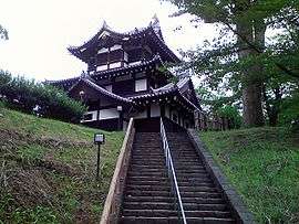
- Takada Castle: Three-story turret located in Takada Park
- Kasugayama Castle: former fortress of warlord and daimyō Uesugi Kenshin
- Takahashi Magozaemon Shouten: oldest running candy store in Japan
- Joetsu Municipal Aquarium Umigatari
- Iwanohara Vineyard Co., Ltd.: one of the oldest wineries in Japan and birthplace of the grape Muscat Bailey A
- Gangi Dori: 16km alleyway of wooden eaves built to shelter pedestrians during heavy snowfall
- Izumi Jomon Park: home to ruins from Japan's Jōmon Period[14]
- Mizushina Kofun group
- Miyaguchi Kofun group
Cultural Events
- Takada Castle Million-Visitor Cherry Blossom Festival
- Joetsu Lotus Festival
- Joetsu Festival
- Kenshin Festival
- Echigo Kenshin Sake Festival
- Lerch Festival
- Candle Road[15]
Sister city relations
Notable people from Jōetsu
- Kenkichi Yoshizawa, diplomat
- Maejima Hisoka, politician, businessman, founder of the Japanese Postal System
- Nana Haruta, manga artist
- Nobutaka Tsutsui, politician
- Ogawa Mimei, children's writer
- Kawakami Zenbei, winemaker, founder of Iwanohara Vineyard
- Uesugi Kenshin, daimyō
References
- ↑ {http://www.city.joetsu.niigata.jp/soshiki/shiminka/jinko.html Jōetsu city official statistics] (in Japanese)
- ↑ Jōetsu climate data
- ↑ "平年値(年・月ごとの値)". Japan Meteorological Agency. Retrieved 2011-11-26.
- ↑ "観測史上1~10位の値(年間を通じての値)". Japan Meteorological Agency. Retrieved 2011-11-26.
- ↑ Jōetsu population statistics
- ↑ "リンク集:上越地域 (Joetsu Region Information)". Niigata Prefecture. Retrieved July 26, 2018.
- ↑ "Takada jo sanju yagura (Takada Castle Three-story-Turret)". Jōetsu Kanko Navi. Retrieved June 18, 2018.
- ↑ "Sakaki Shrine". Jōetsu Kanko Navi. Retrieved June 18, 2018.
- ↑ "Japan Ski Origins Museum". Jōetsu Kanko Navi. Retrieved June 18, 2018.
- ↑ "Unbroken". laurahillenbrandbooks. Retrieved August 2, 2018.
- ↑ "Japan-Australia Society of Joetsu". Japan-Australia Society of Joetsu. Retrieved August 2, 2018.
- ↑ "Number of Officials and Staff". Joetsu University of Education. Retrieved July 26, 2018.
- ↑ "Sado Kisen". Sado Kisen. Retrieved August 18, 2018.
- ↑ "Sightseeing Spots". Jōetsu Kanko Navi. Retrieved July 30, 2018.
- ↑ "Calendar of Events". Jōetsu Kanko Navi. Retrieved July 30, 2018.
Further reading
- "Mount Yoneyama". Gaijin Pot. Retrieved June 18, 2018.
External links

- Official Website (in Japanese)
- Jōetsu Tourism Promotion Division
| Wards of Niigata | ||
|---|---|---|
| Special cities | ||
| Cities | ||
| Districts | ||