Kawasaki, Kanagawa
| Kawasaki 川崎市 | |||
|---|---|---|---|
| Designated city | |||
| Kawasaki City | |||
 Kawasaki Daishi, Tama River Lazona Kawasaki Plaza, Musashi-Kosugi area Todoroki Athletics Stadium Keihin industrial area | |||
| |||
 Location of Kawasaki in Kanagawa Prefecture | |||
 Kawasaki | |||
| Coordinates: 35°31′N 139°42′E / 35.517°N 139.700°ECoordinates: 35°31′N 139°42′E / 35.517°N 139.700°E | |||
| Country | Japan | ||
| Region | Kantō | ||
| Prefecture | Kanagawa Prefecture | ||
| Government | |||
| • Mayor | Norihiko Fukuda | ||
| Area | |||
| • Total | 142.70 km2 (55.10 sq mi) | ||
| Population (April 1, 2017) | |||
| • Total | 1,496,035 | ||
| • Density | 10,000/km2 (27,000/sq mi) | ||
| Time zone | UTC+9 (Japan Standard Time) | ||
| - Tree | Camellia | ||
| - Flower | Azalea | ||
| Phone number | 044-200-2111 | ||
| Address | 1 Miyamoto-chō, Kawasaki-ku, Kawasaki-shi, Kanagawa-ken 210-8577 | ||
| Website | http://www.city.kawasaki.jp/ | ||


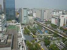
Kawasaki (川崎市 Kawasaki-shi) is a city in Kanagawa Prefecture, Japan. It is the 8th most populated city in Japan (including the Tokyo Metropolitan Area) and one of the main cities forming the Greater Tokyo Area and Keihin Industrial Area.[1]
As of October 1, 2017, the city has an estimated population of 1,503,690, with 716,470 households,[2] and a population density of 10,000 persons per km2. The total area is 142.70 km2 (55.10 sq mi).
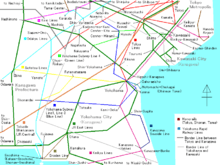
Wards
| Wards of Kawasaki | |
|---|---|
Kawasaki has seven wards (ku):
|
|

Politics and government
Kawasaki is governed by Mayor Norihiko Fukuda, an independent elected on 27 October 2013.[3] The city assembly has 63 elected members. Mayor Fukuda was re-elected to a second term in office on 22 October 2017[4][5].
Elections
Sports
Facilities
Baseball
- Kawasaki Stadium: Located in Kawasaki-ku. Opened in 1952, and was used as a home field for professional baseball teams (see below) from 1954 to 1991. The stands were taken down in 2001, and is currently used for American football games and other events in addition to baseball.
- Kawasaki Todoroki Baseball Stadium: Located in Nakahara-ku. Maximum capacity of 5,000 people. Used for preliminary rounds of high school baseball and American football games.
Field athletics & soccer
- Todoroki Athletics Stadium: Located in Nakahara-ku. Maximum capacity of 25,000 people. Opened in 1964, the stadium underwent several renovations before becoming the home field for the Kawasaki Frontale. Also used frequently for track & field competitions.
Indoor facilities
- Kawasaki Prefectural Gymnasium: Located in Kawasaki-ku. Opened in 1956, and is used for Puroresu matches. 20 minutes walking distance from Kawasaki Station's east entrance.
- Kawasaki Todoroki Arena: Located in Nakahara-ku. International field athletics and volleyball matches are held here, in addition to various musical concerts.
Cycling & horseracing
- Velodrome: Kawasaki Velodrome[6]
- Kawasaki Keiba[7]
Economy
Fujitsu's Main Branch is located in Nakahara-ku.[8] It was formerly Fujitsu's headquarters.[9]
Kawasaki has several factories and development bases of the companies of heavy industry (e.g., JFE Group, Nippon Oil Corporation) and high technology (Fujitsu, NEC Corporation, Toshiba, Dell Japan and Sigma Corporation[10]).
Transportation
Railway stations
- ■ East Japan Railway Company
- ■ Tōkaidō Main Line
- - Kawasaki -
- ■ Keihin-Tōhoku Line
- - Kawasaki -
- ■ Nambu Line
- Main Line : Kawasaki - Shitte - Yakō (Yakō Station is in Tsurumi-ku, Yokohama) - Kashimada - Hirama - Mukaigawara - Musashi-Kosugi - Musashi-Nakahara - Musashi-Shinjō - Musashi-Mizonokuchi - Tsudayama - Kuji - Shukugawara - Noborito - Nakanoshima - Inadazutsumi -
- Branch Line : Shitte - Hatchōnawate - Kawasaki-Shinmachi - Hama-Kawasaki
- ■ Tsurumi Line
- Main Line : - Musashi-Shiraishi - Hama-Kawasaki - Shōwa - Ōgimachi
- Ōkawa Branch : - Ōkawa
- ■ Yokosuka Line, Shōnan-Shinjuku Line
- - Musashi-Kosugi - Shin-Kawasaki -
- ■ Odakyu Electric Railway
- ■ Odakyū Line
- - Noborito - Mukōgaoka-Yūen - Ikuta - Yomiuri-Land-mae - Yurigaoka - Shin-Yurigaoka - Kakio
- ■ Tama Line
- Shin-Yurigaoka - Satsukidai - Kurihira - Kurokawa - Haruhino -
- ■ Keio Corporation
- ■ Sagamihara Line
- - Keiō-Inadazutsumi - Keiō-Yomiuri-Land - Inagi (Keiō-Yomiuri-Land Station and Inagi Station are in Inagi, Tokyo.) - Wakabadai
- ■ Keikyu Corporation
- ■ Keikyū Main Line
- - Hatchōnawate - Keikyū Kawasaki -
- ■ Daishi Line
- Keikyū Kawasaki - Minatochō - Suzukichō - Kawasaki-Daishi - Higashi-Monzen - Sangyō-Dōro - Kojimashinden
- ■ Tokyu Corporation
- ■ Tōyoko Line
- - Shin-Maruko - Musashi-Kosugi - Motosumiyoshi -
- ■ Meguro Line
- - Shin-Maruko - Musashi-Kosugi - Motosumiyoshi -
- ■ Den-en-toshi Line
- - Futako-Shinchi - Takatsu - Mizonokuchi - Kajigaya - Miyazakidai - Miyamaedaira - Saginuma -
- ■ Ōimachi Line
- - Futako-Shinchi - Takatsu - Mizonokuchi
Highways
- Expressway
- Tōmei Expressway is a north-south expressway running from Tokyo to Nagoya and in central area. Tōmei-Kawasaki Interchange is served from Kawasaki.
- Daisan Keihin Road is a north-south expressway running from Tokyo to Hodogaya-ku, Yokohama and in central area. Keihin-Kawasaki Interchange is served from Kawasaki.
- Shuto Expressway Route K1 (Yokohane Route) is a north-south expressway running from Shuto Expressway Route 1 to Shuto Expressway Route K3 (Kariba Route) and in southern area. Daishi Interchange, Hama-Kawasaki Interchange, and Asada Interchange are served from Kawasaki.
- Bayshore Route is a north-south expressway running from Kanazawa-ku, Yokohama to Ichikawa, Chiba and in southern area. Ukishima Interchange and Higashi-Ōgishima Interchange are served from Kawasaki.
- Shuto Expressway Route K6 (Kawasaki Route) is an expressway in southern area. Daishi Interchange, Tonomachi Interchange, and Ukishima Interchange are served from Kawasaki.
- Tokyo Bay Aqua-Line is an expressway across Tokyo Bay from Kawasaki-ku, Kawasaki to Kisarazu, Chiba. Ukishima Interchange is served from Kawasaki.
- National Route
- National Route 1 and 15 are north-south highways running in southern area. Due to elongated territory from east to west, these highways run short length in Kawasaki.
- Japan National Route 246 is a north-south highways running in central area. It also runs short length in Kawasaki.
- Japan National Route 132 is short highway running in southern area. It bounds National Route 15 and port of kawasaki.
- Japan National Route 357 is an industrial highway in southern area. It runs only in Higashi-Ōgishima Island in Kawasaki.
- Japan National Route 409 is a highway running from Takatsu-ku, Kawasaki to Narita, Chiba. It bounds central area and downtown area in Kawasaki.
Places of interest

- Kanayama Shrine: Site of the annual Kanamara Matsuri (Festival Of The Steel Phallus).
- Kawasaki Daishi: the second most visited temple in the Kantō region
- Nihon Minka-en: a park with a collection of 20 minka, or traditional farmhouses, from various areas in Japan
- Koreatown: eastern Kawasaki has the second largest concentration of Koreans in Japan after Osaka. In 1997 it became the first municipality to allow non-Japanese nationals to take civil service employment.
- Todoroki Ryokuchi: athletic park
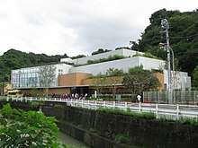
- Fujiko F. Fujio Museum: also known as Doraemon museum, opened on September 3, 2011, in Tama-ku Ward.[11][12]
- Nakagawa stable: stable of professional sumo wrestler
- Kawasaki Warehouse: An amusement arcade whose aesthetic is inspired by the Kowloon Walled City.[13]
International relations
Twin cities
Kawasaki is twinned with the following cities in Japan and worldwide.
Domestic Friendship Cities

International


Friendship ports
References
- ↑ http://www.city.yokohama.lg.jp/ex/stat/jinko/city/new-e.html
- ↑ http://www.city.yokohama.lg.jp/ex/stat/jinko/city/new-e.html
- ↑ http://www.japantimes.co.jp/news/2013/10/28/national/suga-downplays-ldp-loss-in-kawasaki-poll/#.UtG_yNJdU1I
- ↑ http://www.sankei.com/politics/news/171022/plt1710220075-n1.html
- ↑ https://mainichi.jp/english/articles/20171023/p2g/00m/0dm/008000c
- ↑ Kawasaki Keirin
- ↑ "Kawasaki Keiba". Archived from the original on 2007-09-16. Retrieved 2007-09-05.
- ↑ "Contact." Fujitsu. Retrieved on February 4, 2009.
- ↑ "Company Profile." Fujitsu. January 19, 1998. Retrieved on May 19, 2009.
- ↑ "Company Summary." Sigma Corporation. Retrieved on September 28, 2015
- ↑ "fujiko-museum". fujiko-museum. Archived from the original on 18 September 2012. Retrieved 3 September 2012.
- ↑ "Anime star Doraemon to have own museum". The Independent. 29 August 2011.
- ↑ "Arcade brings Kowloon Walled City back from the dead … in Japan". South China Morning Post. 1 October 2013.
- ↑ "Baltimore City Mayor's Office of International and Immigrant Affairs - Sister Cities Program". Archived from the original on August 7, 2008. Retrieved 2009-07-18.
External links
| Wikimedia Commons has media related to Kawasaki, Kanagawa. |

- Official Website (in Japanese)
| Wards of Yokohama | ||
|---|---|---|
| Wards of Kawasaki | ||
| Wards of Sagamihara | ||
| Core city | ||
| Special cities | ||
| Cities | ||
| Districts | ||