Higashitsugaru District, Aomori
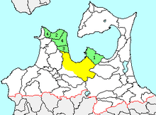
green - current
yellow - former extent in early Meiji period
1. - Hiranai
2. – Imabetsu
3. - Kanita
4. – Sotogahama
Higashitsugaru District (東津軽郡 Higashitsugaru-gun) is a rural district located in Aomori Prefecture, Japan.
As of September 2013, the district had an estimated population of 24,011 and an area of 652.83 km². Much of the city of Aomori was formerly part of Higashitsugaru District.
Towns and villages
History
The area of Higashitsugaru District was formerly part of Mutsu Province. At the time of the Meiji restoration of 1868, the area consisted of one towns (Aomori) and 137 villages, formerly under the control of Hirosaki Domain and 28 villages under the control of Kuroishi Domain. Aomori Prefecture was founded on December 13, 1871, and Higashitsugaru District was carved out of the former Tsugaru District on October 30, 1878.

1.Aomori 2.Uramachi 3.Ōno 4.Takada 5.Takiuchi 6.Okuuchi 7.Yomogita 8.Tairadate 9.Imabetsu 10.Yokouchi 11.Hamadate 12. Azumadake 13.Nishi-Hiranai 14.Arakawa 15.Aburakawa 16.Shinjo 17.Ushirogata 18.Kanita 19.Ippongi 20.Minmaya 21.Tsutsui 22.Harabetsu 23.Nonai 24.Naka-Hiranai, later Kominato 25. Higashi-Hiranai
Purple= Aomori City, Pink=Hiranai, Orange=Imabtesu, Red=Sotogahama, Light Blue=Yomogita
History
With the establishment of the municipality system on April 1, 1889, Higashitsugaru District, organized into one town (Aomori) and 24 villages, was established. It is to be noted that when a municipality is elevated to, or is absorbed into a city, it ceases to be part of a district. For example, when the village, Nonai was incorporated into the city of Aomori as a neighborhood, it ceased to be part of a rural district.
- 1898 – Aomori was elevated to city status.
- 1919 – Aburakawa was elevated to town status.
- 1928 – Kominato was elevated to town status
- 1939 – Aburakawa was merged into the city of Aomori
- 1941 – Kanita was raised to town status
- 1951 – Tsutsui was raised to town status
- 1955 – Kominato absorbed two neighboring villages to become the town of Hiranai. Imabetsu was also raised to town status
- 1962 – Nonai was merged into Aomori.
- On March 28, 2005 - the town of Kanita and the villages of Tairadate and Minmaya were merged to form the new town of Sotogahama.