Yamaguchi (city)
| Yamaguchi 山口市 | ||
|---|---|---|
| City | ||
| Yamaguchi City | ||
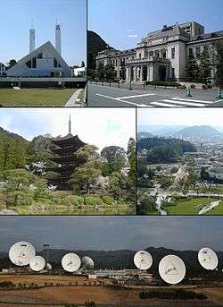 From top left:Yamaguchi Xavier Memorial Church, Yamaguchi Prefectural Government Museum, Ruriko-ji Five-storied pagoda, View of Yamaguchi, Yamaguchi Satellite Earth Station,KDDI Corporation | ||
| ||
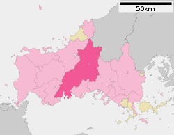 Location of Yamaguchi in Yamaguchi Prefecture | ||
 Yamaguchi Location in Japan | ||
| Coordinates: 34°11′N 131°28′E / 34.183°N 131.467°ECoordinates: 34°11′N 131°28′E / 34.183°N 131.467°E | ||
| Country | Japan | |
| Region | Chūgoku (San'yō) | |
| Prefecture | Yamaguchi Prefecture | |
| Government | ||
| • Mayor | Sumitada Watanabe | |
| Area | ||
| • Total | 1,023.31 km2 (395.10 sq mi) | |
| Population (February 1, 2010) | ||
| • Total | 198,971 | |
| • Density | 194.44/km2 (503.6/sq mi) | |
| Symbols | ||
| • Tree | Ginkgo | |
| • Flower | Rapeseed flowers, Sakura | |
| Time zone | UTC+9 (JST) | |
| City hall address |
2-1 Kameyama-cho, Yamaguchi-shi, Yamaguchi-ken 753-8650 | |
| Website |
www | |


Yamaguchi (山口市 Yamaguchi-shi, literally "the entrance to the mountain") is the capital city of Yamaguchi Prefecture, Japan. The city was founded on April 10, 1929.
As of February 1, 2010, the city had an estimated population of 198,971 and a population density of 194.44 persons per km². The total area is 1,023.31 km².
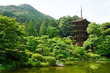
Yamaguchi has claim to two famous religious sites: the Buddhist temple, Rurikō-ji (瑠璃光寺 Rurikō-ji), with its five-story pagoda, and the Roman Catholic cathedral connected with Saint Francis Xavier whose work was responsible for the introduction of Christianity to Japan in 1550.
Yamaguchi is served by Yamaguchi Ube Airport in nearby Ube.
Merger history
- April 1, 1889: 40 towns were merged to form the town of Yamaguchi.
- April 1, 1905: The village of Kami-unorei was merged into the town of Yamaguchi.
- July 1, 1915: The village of Shimo-unorei was merged into the town of Yamaguchi.
- April 10, 1929: The town of Yamaguchi absorbed the village of Yoshiki to create the city of Yamaguchi (1st Generation).
- April 1, 1941: The village of Miyano was merged into the city of Yamaguchi.
- April 1, 1944: The towns of Ogōri and Ajisu, and the villages of Hirakawa, Ōtoshi, Sue, Natajima, Aiofutajima, Kagawa and Sayama were merged with the city of Yamaguchi (1st Generation) to become the new city of Yamaguchi (2nd Generation). (At that time of the merger, all of them were from Yoshiki District.)
- November 23, 1947: The town of Ajisu was broken off from Yamaguchi.
- November 1, 1949: The town of Ogōri was broken off from Yamaguchi.
- November 3, 1963: The village of Suzenji (from the Yoshiki District) merged into Yamaguchi.
- May 1, 1963: The town of Ōuchi (from Yoshiki District) was merged into Yamaguchi.
- October 1, 2005: Yamaguchi (2nd Generation) merged with town of Tokuji (from Saba District), and the towns of Aio, Ajisu and Ogōri (all from Yoshiki District) to create the 3rd city of Yamaguchi. Yoshiki District was dissolved as a result of this merger.
- January 16, 2010: Yamaguchi absorbed the town of Atō (from Abu District).
Climate
Yamaguchi has a humid subtropical climate (Köppen climate classification Cfa) with hot summers and cool winters. Precipitation is significant throughout the year, but is much higher in summer than in winter.
| Climate data for Yamaguchi, Yamaguchi | |||||||||||||
|---|---|---|---|---|---|---|---|---|---|---|---|---|---|
| Month | Jan | Feb | Mar | Apr | May | Jun | Jul | Aug | Sep | Oct | Nov | Dec | Year |
| Average high °C (°F) | 8.6 (47.5) |
9.4 (48.9) |
13.2 (55.8) |
19.1 (66.4) |
23.5 (74.3) |
26.5 (79.7) |
30.1 (86.2) |
31.4 (88.5) |
27.5 (81.5) |
22.3 (72.1) |
16.8 (62.2) |
11.2 (52.2) |
20 (67.9) |
| Daily mean °C (°F) | 3.7 (38.7) |
4.4 (39.9) |
7.6 (45.7) |
13.4 (56.1) |
17.9 (64.2) |
21.8 (71.2) |
25.7 (78.3) |
26.6 (79.9) |
22.5 (72.5) |
16.5 (61.7) |
10.8 (51.4) |
5.7 (42.3) |
14.7 (58.5) |
| Average low °C (°F) | −0.5 (31.1) |
0.1 (32.2) |
2.4 (36.3) |
7.6 (45.7) |
12.3 (54.1) |
17.5 (63.5) |
22.1 (71.8) |
22.7 (72.9) |
18.4 (65.1) |
11.4 (52.5) |
5.9 (42.6) |
1.1 (34) |
10.1 (50.2) |
| Average precipitation mm (inches) | 73.4 (2.89) |
91.1 (3.587) |
142.3 (5.602) |
199.8 (7.866) |
175.7 (6.917) |
305.4 (12.024) |
299.2 (11.78) |
154.0 (6.063) |
180.9 (7.122) |
97.6 (3.843) |
71.2 (2.803) |
53.5 (2.106) |
1,844.1 (72.603) |
| Average snowfall cm (inches) | 15 (5.9) |
15 (5.9) |
3 (1.2) |
0 (0) |
0 (0) |
0 (0) |
0 (0) |
0 (0) |
0 (0) |
0 (0) |
0 (0) |
5 (2) |
38 (15) |
| Average relative humidity (%) | 76 | 75 | 73 | 71 | 72 | 77 | 80 | 78 | 79 | 77 | 78 | 68 | 75 |
| Mean monthly sunshine hours | 120.2 | 119.2 | 161.0 | 181.6 | 203.4 | 159.0 | 174.6 | 203.2 | 157.4 | 178.0 | 144.6 | 128.1 | 1,930.3 |
| Source: NOAA (1961-1990)[1] | |||||||||||||
Media
Newspaper
TV
Places of interest
- Rurikō-ji, a five-story pagoda and national treasure
- Yamaguchi Xavier Memorial Church
- Yamaguchi Prefectural Museum of Art
- Chūya Nakahara Memorial Museum
- Yuda Onsen
Education
Transportation
Railways
Expressways
Sister cities


Notes
- 1.^ Kami-Kanakoso, Shimo-Kanakoso, Yawatanobaba, Noda, Kami-Tatekōji, Shimo-Tatekōji, Ishigan-non, Dōso, Enseiji, Dōnomae, Ōichi, Shogan-shōji, Kubo-shōji, Sentō-shōji, Shinbaba, Ushirogawara, Nakagawara, Hayamada, Shin, Komeya, Otsubone-shōji, Ima-shōji, Nakaichi, Aimono-shōji, Tachiuri, Matsunoki, Kitano-shōji, Babadono-shōji, Yonedono-shōji, Dōjōmonzen, Imaichi, Imamichi, Wani-ishi, Ōzuke, Shinbashi, Nishimonzen, Itoyone-shōji, Arataka, Ta and Nakasanai (all from Yoshiki District)
References
- ↑ "Yamaguchi Climate Normals 1961-1990". National Oceanic and Atmospheric Administration. Retrieved January 6, 2013.
External links

- Yamaguchi City official website (in Japanese)
| Wikivoyage has a travel guide for Yamaguchi. |
| Core city | ||
|---|---|---|
| Cities | ||
| Districts | ||